Colonial Mexico
(Day 6) Dolores Hidalgo & San Miguel De Allende
The route to Dolores Hidalgo reverses the route from the way in. Depart Guanajato climbing back up the mountain toward the Valenciana Mine and Church and continue on the road to Dolores Hidalgo, about 30 miles away. As you approach Dolores Hidalgo follow the signs (or ask directions) to the main plaza. You will see the large Cathedral steeples as you draw closer to the plaza. Dolores is a small town so finding your way will not be complicated. The plaza is a great place to have lunch, visit the Cathedral (where the Mexican Independence Movement began), and if you are interested in Mexico's Independence struggle from Spain, visit the Independence Museum about a block of the Plaza.
 Known
in Mexico as ''Cuna de la Independencia Nacional'' (The Cradle
of National Independence) and designated a national historic
monument, Dolores Hidalgo lies in the valley of the Río
Laja. Just before midnight on Sept. 15, 1810, Father Miguel Hidalgo
y Costilla called together his parishioners by ringing the village
church bell. He then gave the venerated Grito de Dolores, a speech
announcing Mexican independence that ignited the 11-year war
to achieve it. A statue of Hidalgo stands in the town's main
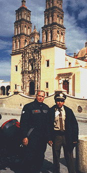
plaza. The picture of the author and a policeman was taken in
front of the church from which Father Hidalgo issued his famous
"call to arms."
Known
in Mexico as ''Cuna de la Independencia Nacional'' (The Cradle
of National Independence) and designated a national historic
monument, Dolores Hidalgo lies in the valley of the Río
Laja. Just before midnight on Sept. 15, 1810, Father Miguel Hidalgo
y Costilla called together his parishioners by ringing the village
church bell. He then gave the venerated Grito de Dolores, a speech
announcing Mexican independence that ignited the 11-year war
to achieve it. A statue of Hidalgo stands in the town's main
plaza. The picture of the author and a policeman was taken in
front of the church from which Father Hidalgo issued his famous
"call to arms."
Casa de Don Miguel Hidalgo (Home of Don Miguel Hidalgo), Morelos #1 at Hidalgo, contains many items relating to the life of the patriot priest, including paintings, portraits, books and period furniture.
Leaving Dolores Hidalgo you simply make your way out of town looking for the road to San Miguel de Allende. It is a short 45 minute ride to San Miguel. This author likes the Hotel Posada de Las Monjas (Home of the Nuns-was an old Nunnery during Colonial days). The hotel is about two blocks from the main plaza. It might be difficult to find as San Miguel is full of one-way streets that seem to dead end at every turn! Recommend you hire a taxi to lead you there. The hotel has good court yard parking and is very convenient to the plaza and activity
 San
Miguel de Allende traces its history to the immediate aftermath
of the Spanish conquest. As mines began to exploit the rich gold
and silver deposits of Mexico's central highland region, mule
trains were formed to carry the bounty back to Mexico City. These
caravans, however, passed through territory occupied by the Chichimeca
Indians, and many a skirmish erupted. The village of San Miguel
was thus founded in 1542 by the Franciscan monk Juan de San Miguel,
who established a mission to evangelize the Indians and also
to teach European weaving and agricultural techniques.
San
Miguel de Allende traces its history to the immediate aftermath
of the Spanish conquest. As mines began to exploit the rich gold
and silver deposits of Mexico's central highland region, mule
trains were formed to carry the bounty back to Mexico City. These
caravans, however, passed through territory occupied by the Chichimeca
Indians, and many a skirmish erupted. The village of San Miguel
was thus founded in 1542 by the Franciscan monk Juan de San Miguel,
who established a mission to evangelize the Indians and also
to teach European weaving and agricultural techniques.
The settlement prospered, becoming the local market center for
surrounding haciendas trading in cattle and textiles. It also
went through several name changes, including San Miguel de los
Chichimecas and San Miguel el Grande. It was here that native
son Ignacio Allende, along with Father Miguel Hidalgo from the
neighboring town of Dolores Hidalgo, planned the initial uprising
that led to the 11-year War of Independence. ''Allende'' was
added to the town's name in 1826 to honor the freedom fighter.
San Miguel entered a period of decline following the war. Its
opulent churches and mansions fell into decay, and poverty set
in as mining operations subsided. But in 1926--a century after
it officially became a city--the Mexican government declared
San Miguel a national historic monument. Modern construction
was prohibited in the city center to preserve its atmosphere,
and the old buildings were restored. Foreigners began moving
in during the 1930s, and today there is a well-established permanent
community of North American expatriates, augmented by teachers,
artists and writers who call San Miguel home for up to 6 months
each year.
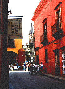 Visitors gravitate downtown, where
coats of arms are carved over the doorways of houses that formerly
belonged to Spanish aristocrats; they prospered from the Zacatecas-Guanajuato-Mexico
City silver route that once ran through San Miguel. Inner patios
shelter fountains, trees and flowers. Some of these handsome
buildings now house commercial banks.
Visitors gravitate downtown, where
coats of arms are carved over the doorways of houses that formerly
belonged to Spanish aristocrats; they prospered from the Zacatecas-Guanajuato-Mexico
City silver route that once ran through San Miguel. Inner patios
shelter fountains, trees and flowers. Some of these handsome
buildings now house commercial banks.
Make your first stop the main plaza, located between calles San
Francisco and Correo and commonly referred to as El Jardín.
Shaded by Indian laurel trees, it's a great place to relax on
a wrought-iron bench, listen to the tolling bells of La Parroquia,
the parish church, and observe the local scene. Artists working
on their canvases are a common sight in the vicinity of the plaza,
and most of the city's attractions are within walking distance.
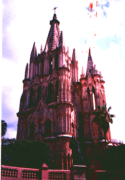 La
Parroquia (Parish Church) is on Calle Correo, facing the south
side of the main plaza. This many-steepled church towers over
the plaza and dominates the city. It was originally built in
the late 17th century in a plain Franciscan style, but 2 centuries
later an Indian artisan, Zeferino Gutiérrez, gave the
church an imposing facelift. With no formal training, he added
the towers and Gothic-style facade of pink-hued sandstone, supposedly
using postcard pictures of French Gothic cathedrals as his inspiration.
La
Parroquia (Parish Church) is on Calle Correo, facing the south
side of the main plaza. This many-steepled church towers over
the plaza and dominates the city. It was originally built in
the late 17th century in a plain Franciscan style, but 2 centuries
later an Indian artisan, Zeferino Gutiérrez, gave the
church an imposing facelift. With no formal training, he added
the towers and Gothic-style facade of pink-hued sandstone, supposedly
using postcard pictures of French Gothic cathedrals as his inspiration.
Inside, neoclassic stone altars have replaced earlier gilded wood ones. A statue of St. Michael the Archangel, namesake of both town and church (its official name is Parroquia de San Miguel Arcángel), adorns the main altar. Chapels are located to the side and behind the main altar. The original bell, also referred to as St. Michael and cast in 1732, begins ringing early in the morning to summon parishioners; La Parroquia is still an active house of worship.
One full afternoon and an evening are sufficient to visit most points of interest in San Miguel. If one where "into" art this town would require a few more days to appreciate the many museums, galleries, and perhaps visit a number of art schools which operate here. Also, if one wanted to study Spanish, San Miguel would be one choice as there are many well recognized Spanish language schools here.
The next stop on our tour of Colonial Spanish towns is the National Colonial Landmark town of Patzcuaro. This unspoiled Colonial town is located about 30 miles south west of the large city of Morrelia. From San Miguel, travel south toward Celaya, to Salvatierra, west to Yuriria, and pick up the main highway to Morrelia. Once you approach Morrelia you will see signs directing you to Patzcuaro. This final part of the route (Morrelia to Patzcuaro) will take you on a major four lane highway. If you want a more scenic route, try going west out of Morrelia to Quiroga and then south from Quiroga to Patzcuaro. This is rolling country and is much more pleasant then the four lane highway. These towns are all on any map of Mexico and easy to find - just ask directions if in doubt!