 |
|
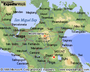
General Vicinity Maps
Mount Isarog National ParkA national park since 1938, 10,112 ha around Mount Isarog (1,976 m) harbors rainforest, endemic wildlife, waterfalls and is home to nomadic Negrito (Agta) tribespeople.The peak is about 20 km east of the town of Naga and the same distance from Pili, the capital of the Camarines Sur Province. Flights go from Manila to Pili which can also be reached by bus from Manila (about 8 hours) or Legazpi (2 hours). Mount Iriga (1,195 m) is located about 30 km south of Isarog near the town of Iriga. It is also called Mount Asog and is a popular trekking destination near Lake Buhi. This area is home to Negritos but is not a protected park. Other national parks in Camarines Sur include Libmanan Caves
N.P. (19 ha) located near the town of Libmanan about 20 km northwest of
Naga, and Caramoan N.P. (347 ha, 1983) not shown on this map but is located
near the town of Caramoan about 40 km east of the town of Lagonoy. Caramoan
N.P. features panoramic hills, caves and seashore.
Other related links on this site: Take me back to Bundok's Maps Page |