|
Devils Postpile National Monument
 The summer of 1977, I took a class at my local community college entitled the "Biology of the Sierra Nevada." Eight weeks studying about the Sierra and the ninth week was the lab, a full week backpacking in the Sierra. We drove up to Big Pine, California on a Saturday and went into the White Mountains to the bristlecone pine forest. These pines are some of the oldest living things on the face of the earth. We spent the night there, hiked around the forest, got slightly sunburned and then drove over to the Mammoth Lakes region to begin our trek into the Sierra. That Sunday is when we went and explored the Devil's Postpile. Devil's Postpile was created when a magma intrusion forced its way up almost to the surface. The rock cooled forming six-sided basaltic columns. During the last ice age, massive glaciers scoured most of the basalt away except for what you see in the picture. The summer of 1977, I took a class at my local community college entitled the "Biology of the Sierra Nevada." Eight weeks studying about the Sierra and the ninth week was the lab, a full week backpacking in the Sierra. We drove up to Big Pine, California on a Saturday and went into the White Mountains to the bristlecone pine forest. These pines are some of the oldest living things on the face of the earth. We spent the night there, hiked around the forest, got slightly sunburned and then drove over to the Mammoth Lakes region to begin our trek into the Sierra. That Sunday is when we went and explored the Devil's Postpile. Devil's Postpile was created when a magma intrusion forced its way up almost to the surface. The rock cooled forming six-sided basaltic columns. During the last ice age, massive glaciers scoured most of the basalt away except for what you see in the picture. 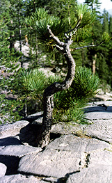 Over the course of years, erosion has caused the columns to break off and tumble down creating the postpile. The Pacific Crest Trail and the John Muir Trail which are the same thing at this point runs along the face of the postpile in a northerly direction. It's a very interesting site. Over the course of years, erosion has caused the columns to break off and tumble down creating the postpile. The Pacific Crest Trail and the John Muir Trail which are the same thing at this point runs along the face of the postpile in a northerly direction. It's a very interesting site.
There are several good hikes in the area including one that takes you back to a soda springs. You can see the bubbles coming up to the surface and see the iron mineral content in the water. If you've never seen a spring before, this is an interesting sidetrip. Also, you can take a short 2 mile hike to Rainbow Falls which drops 101 feet. I've heard reports that during the middle of the day, rainbows form because of the spray from the waterfall. We were on a strict time schedule on this backpacking trip and weren't able to get out to the waterfall. Rule number 1 in camping is to take your time and enjoy the sites that are there. Next time I get out to Devils Postpile, you can be sure I'll head out to Rainbow Falls.
There is also a steep hike up to the top of Devils Postpile and the second picture is taken on top of the postpile. I like the almost "patio" feel to the picture as you can see the glacial scour and the smoothness of the top of the postpile as the glacier ground over the top of it during the last ice age. Since this picture was taken in 1977, I'd like to take the kids back to it someday and try and find that same tree. It would be interesting to see how much it had grown in the last twenty years or so.
Next national park site.
Back to the National Park Page.
This backpacking trip also included stops at Manzanar and the High Sierra.
|
