|
 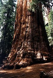 The summer of 1997, we were fortunate to spend a week in the Sierra Nevada camping in Sequoia National Park. We drove up through Visalia on the Generals Highway which is incredibly twisting and curvy. You get great views of Moro Rock on the road and you come around a corner and the first big tree is upon you. Around another turn are the Four Guardsmen, which are four moderate size Sequoias that happen to be more or less in line. As you can see, the road splits and drives in between them. Sequoias are interesting trees as they have no tap root to speak of, but have spreading roots which extend out hundreds of feet in all directions. They are fairly impervious to insects and other forms of diseases and are seemingly immortal. The only thing that people can agree kills a Sequoia is toppling. These roads could be the downfall of these trees here, but only time will tell. The Giant Forest area (a small town in most estimations), which has a tremendous impact on the big trees is slowly being dismantled so the Giant Forest won't have as much foot traffic. The lodges will be moved out of the big tree area so the roots of the trees won't as easily be disturbed. The summer of 1997, we were fortunate to spend a week in the Sierra Nevada camping in Sequoia National Park. We drove up through Visalia on the Generals Highway which is incredibly twisting and curvy. You get great views of Moro Rock on the road and you come around a corner and the first big tree is upon you. Around another turn are the Four Guardsmen, which are four moderate size Sequoias that happen to be more or less in line. As you can see, the road splits and drives in between them. Sequoias are interesting trees as they have no tap root to speak of, but have spreading roots which extend out hundreds of feet in all directions. They are fairly impervious to insects and other forms of diseases and are seemingly immortal. The only thing that people can agree kills a Sequoia is toppling. These roads could be the downfall of these trees here, but only time will tell. The Giant Forest area (a small town in most estimations), which has a tremendous impact on the big trees is slowly being dismantled so the Giant Forest won't have as much foot traffic. The lodges will be moved out of the big tree area so the roots of the trees won't as easily be disturbed.
One of the neat aspects of both Sequoia and Kings Canyon National Parks, is they are home to more than 130 caves. The caves are marble bed rock formed by acidic ground water flowing through this rock. Crystal Cave is the best known and is open for regular tours during the summer months. The temperature inside Crystal Cave is a cool 48 degrees winter or summer.  You could actually feel the air moving into the cave as there was about a thirty degree difference between outside and underground. In the winter the air flow is just the opposite as it is warmer underground than outside. There are many typical cave formations. The one shown here is called the "Fairy Pools." For part of the tour we followed a underground stream bed. You could actually feel the air moving into the cave as there was about a thirty degree difference between outside and underground. In the winter the air flow is just the opposite as it is warmer underground than outside. There are many typical cave formations. The one shown here is called the "Fairy Pools." For part of the tour we followed a underground stream bed. 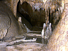 The marble had a bluish tint to it. It was probably a gray color but it was just beautiful. I have discovered a real love for caving and plan to do some more spelunking in the next few years. I have been fortunate, while I was growing up, to be in quite a few caves. I was in Wind Cave in South Dakota which has some very interesting features and about 12 years ago I was able to visit Carlsbad Caverns in New Mexico. There is nothing to compare these caves, that I know. The marble had a bluish tint to it. It was probably a gray color but it was just beautiful. I have discovered a real love for caving and plan to do some more spelunking in the next few years. I have been fortunate, while I was growing up, to be in quite a few caves. I was in Wind Cave in South Dakota which has some very interesting features and about 12 years ago I was able to visit Carlsbad Caverns in New Mexico. There is nothing to compare these caves, that I know.
We hiked to the top of Moro Rock twice. The first time, the view wasn't nearly as spectacular as it was on our second trek up the rock. Moro Rock is a granite dome  which has had a staircase added to it so visitors can climb to the top and view the Great Western Divide of the Sierra Nevada. The mountains were still covered with snow in early June, which was surprising since very little snow had fallen since February in the Sierras. From the top of Moro Rock, we could barely see the Central Valley of California, due to the smog which is encroaching upon the parks. Some sugar pines are showing damage due to ozone pollution. No one is quite sure what damage the smog is doing to the Giant Sequoias, but steps need to be taken to prevent them from being damaged by the air pollution. The two views of the Great Western Divide are to the east and a little bit south. They almost form one large picture if I could glue them together. I was fortunate the clouds came in that day as it made for a very interesting view. Without the clouds, the view is great, but not nearly as interesting. which has had a staircase added to it so visitors can climb to the top and view the Great Western Divide of the Sierra Nevada. The mountains were still covered with snow in early June, which was surprising since very little snow had fallen since February in the Sierras. From the top of Moro Rock, we could barely see the Central Valley of California, due to the smog which is encroaching upon the parks. Some sugar pines are showing damage due to ozone pollution. No one is quite sure what damage the smog is doing to the Giant Sequoias, but steps need to be taken to prevent them from being damaged by the air pollution. The two views of the Great Western Divide are to the east and a little bit south. They almost form one large picture if I could glue them together. I was fortunate the clouds came in that day as it made for a very interesting view. Without the clouds, the view is great, but not nearly as interesting.
The butterfly at the left, just seemed to want to pose for me. I took this one on a hike back deep into the Sequoia groves on a loop trail behind the Congress Trail.  The Congress Trail during the summer months is almost as bad as the John Muir Trail, a veritable freeway in some aspects. We left this trail at "the Senate" group and had the trees and trail to ourselves. The Congress Trail during the summer months is almost as bad as the John Muir Trail, a veritable freeway in some aspects. We left this trail at "the Senate" group and had the trees and trail to ourselves. 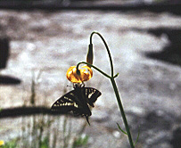 Take some of those side trails. No one seems to know they exist and you can have peace and solitude there. I hope you enjoy these pictures. I also have some from Kings Canyon National Park which we also went to on the same trip. Take some of those side trails. No one seems to know they exist and you can have peace and solitude there. I hope you enjoy these pictures. I also have some from Kings Canyon National Park which we also went to on the same trip.
Next national park site.
Back to the National Park Page.
Information about camping here.

|
