
|
|
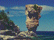
If you drive from Wiarton to Tobermory along the main highway, you would wonder why one might call this a green space. But, on the Bruce Trail, which runs along the Georgian Bay side of the peninsula, you would see deep blue waters and steep rocky shorelines. There are ancient white cedars over 700 years old here, open fens and bogs, as well as the prairie-like open fields visible from the highway. The Bruce also combines elements of the Boreal Forest, Mixed Forest and Eastern Deciduous (Carolinian) Forest. This is one of the finest locations for viewing wild orchids in North America north of Florida.
Here too there are caves and sinkholes, and Ontario's only venomous snake, the reclusive Massasauga Rattlesnake. Fans of The Pilgrim's Progress will want to visit the Slough of Despond. The Niagara Escarpment in this area is rich in fossils originating from ancient coral seas.
Caves 40 metres (100 feet) above the current water level were formed by wave
action when the land was pushed down by the massive weight of
invading glaciers. There are also underwater caves
below the current lake level which were formed during a period when the water level
was much lower.
Fathom Five Marine Park is a "National Marine Conservation Area" like the junction of the Saguenay River with the Saint Lawrence.
![[home]](gsbann.gif)