
Mount Belford and Mount Oxford are not the most impressive-looking mountains of the
Sawatch Range. Both rise as large humps above and on either side of the Belford Gulch
basin, just southeast of the old mining community of Vicksburg, now a ghost town of which
very little remains. The two mountains are connected by a 1 1/2 mile ridge which only
drops 700 feet, thus making it possible to hike to both summits in a single day. Some
people even take in a third, Missouri Mountain, though we would
not recommend it!
To get there, turn west on Clear Creek Canyon Road, 14 miles north of Buena Vista just south of Granite, off US Highway 24. The road winds around the north side of Clear Creek Resevoir (not visible from US 24) and into the the canyon. After eight dusty miles of the dirt road there is a large trailhead parking lot with an east and a west entrance, just across the road from Vicksburg.
The trailhead sits at the mouth of Missouri Gulch, which drains to the west of Mt. Belford. You cannot see either mountain from the trailhead - you must hike up along the gulch to a large, beautiful alpine basin to get your first glimpse of Mt. Belford, as shown in the photo to the right.
Since camping is not allowed at the trailhead (and we didn't have the equipment to hike in to camp), we headed further west about a quarter of a mile to a small pullout on the south side of the road. We set up camp south of a dry bed of an off-shoot of Clear Creek and into a grove of mosquito-infested trees along the banks of Clear Creek, totally hidden from the road. It rained from 2:00 in the afternoon until shortly after 7:00 pm, ruining any chances we had for a campfire.
On the morning of August 15, 1998, we rose at 5:15 am and hit the trail at 6:05. From the parking lot, the trail heads down to cross Clear Creek at 9,669 feet in elevation, then up the south side, pretty much straight up a hillside west of Missouri Gulch. After a while you'll notice the Vicksburg cemetary on your left, which consists of one marked and fenced grave - William Huffman, who died in 1884 of pneumonia at the age of one month.
Continuing a bit farther, you will come to a series of eight switchbacks which climb the hill. After the 8th the trail straightens out as you head south, paralleling the gulch to its west, but at a much lessened grade. At about 10,800 feet the trail crosses Missouri Gulch on a three-log bridge which bounces uneasily as you put your weight on it. We crossed at 6:55.
Once on the east side of the gulch, the trail again shoots straight south for a way before coming to another series of switchbacks as the hill gets steeper. There are few trees on this portion of the hill, so you are afforded a beautiful view of the valley from which you have come.
Once you're through the switchbacks, the path again levels out somewhat as you enter a heavily wooded area. Suddenly you arrive at Joe Anderson's mining cabin, circa 1879, at 11,280 feet. There's not a lot left of Joe's abode - just four walls and a caved-in roof that now sits on the floor - but, thankfully, there are a couple of logs on the south side of the cabin that are perfect for sitting or leaning against to take a rest.
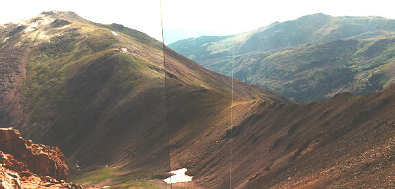
 Just past the remains
of Joe's cabin, the trees clear and you enter onto the Missouri Gulch basin. From here,
you get your first view of Mt. Belford, which you can see in the top picture, above. The
trail leads across the basin to a fork at 11,600 feet where there is a signpost pointing
you east (left) for Mt. Belford, or south (straight) for Elkhead Pass at the end of the
basin.
Just past the remains
of Joe's cabin, the trees clear and you enter onto the Missouri Gulch basin. From here,
you get your first view of Mt. Belford, which you can see in the top picture, above. The
trail leads across the basin to a fork at 11,600 feet where there is a signpost pointing
you east (left) for Mt. Belford, or south (straight) for Elkhead Pass at the end of the
basin.
Taking the Belford fork will lead you across the basin toward the northwest ridge of the mountain. It's the to the right of the peak, but facing you, as you look at the picture above. Crossing the basin leads you through a field of columbines, Colorado's state flower.
As you reach where the mountain rises from the basin, you must cross a small stream of running water, then climb steeply up a series of stone steps which is followed by a series of switchbacks leading up the mountain just west (to the right) of the edge of the ridge. Following this path eventually brings you due west of the summit, then heads onto a yellow/orange rock up to the summit. We arrived on top at 9:30 am, the second and third persons to arrive there that day.
From the summit, you get a great view of Mt. Oxford to the east and Missouri Mountain to the west. If you wish to summit Oxford, too, head south off Belford's summit along a long ridge to the point where it hooks up to the east-west ridge connecting it with Mt. Oxford. Here's what Mt. Oxford looks like from just south of Belford's summit:
As stated earlier, there is a 700 foot drop and 1 1/2 miles between the two summits. Going down isn't bad, of course, but before you start for Oxford you should know that you'll have to go down the 700 feet, go up the 700 feet to Oxford's summit, go back down the 700 feet, and then back up the 700 feet to Belford's summit again before you can start your descent to get back to camp. Be forewarned that the Belford drop to the connecting ridge is steeper than Oxford's - so you have to do the hardest, last. Here's what it looks like looking back at Belford from Oxford's summit. The ridge you have to go down, then up, is near the center of the photo.

We made Oxford's summit at 10:50 am and had lunch taking in a wonderful view of Mt. Harvard and the Collegiate Peaks Wilderness to the south. Once you're ready leave the summit, don't get tempted to head back down to the saddle and then down into Belford Gulch basin without summiting Belford again. Though it looks simple enough from here, don't forget that you would eventually have to cross Clear Creek - and there's no bridge at the bottom to help you!
We hit Belford's summit the second time at 12:20 pm, joining about 10 other people who were there by this time. Continuing on down the way we came up, we made it back to the trailhead at 3:00 pm - a great hike! The trail is in excellent shape throughout.
This page hosted by ![]() Get your own Free Home Page
Get your own Free Home Page