| Namibian leg
|
|
|
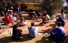
| The rear of the bus was abuzz as conversations were struck at the outset of the journey, competing with the sounds of Alanis Morisette emanating from the speakers. Spirits were high. Events on the first day set the tone for the rest of the tour - "Elsie Geselsie" had just made her presence known to all and sundry. This caused our guides to remark later that we were the "most diverse group" they had ever taken from Cape Town to Kenya. Upon request, daily kitchen duty groups were formed. I volunteered instead for bus packing duty, a ritual that would be performed whenever we were on the move. It would at least involve some exercise, I figured. By the time we approached Springbok, the site of our first camp, the skies were overcast. Tents were pitched on fairly hard ground near the motel. It began to rain. The tour had earlier claimed it's first roadside victim in the form of Jo's sentimental bunny rabbit pillow. The maiden dinner of the tour, a spaghetti bolognaise stir-fry mix, had gone down exceptionally well with a bit of red wine. The first kitchen duty team had indeed set the standard. Well, if temperatures in Springbok were anything to go by, the bunny rabbit would be spending a cold night on the prairie. |
| The border crossing at Noordover
passed without incident. The landscape altered dramatically, the further north one
ventured; rock formations became more bizarre. At Hobas Camp we met up with the WhichWay
Namibian tour group. I experienced difficulty sleeping in my side on the hard surface. If
I slept on my back, I would be inclined to snore much like a runaway motorboat (on
occasions aggravated when preceded by excessive partying), much to the annoyance of my
tent partner, Marku, an Australian Finn, or was it a Finnish Australian? Whatever, he
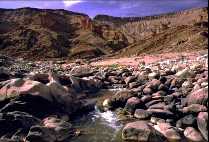
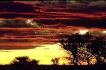
wasn't in the least amused! We drove to the Fish River Canyon lookout and then to where the 85km canyon-hiking trail commenced; ours would only be a day walk into the depths below. As usual I took up the rear, biding my time in photographing the picturesque landscape. After a walk of a couple of hours, we were cavorting in the refreshingly icy waters. Perched on a rock out in the middle, we basked in the exquisite warmth of the radiating sun. Claus and I indulged in one of many of our many impromptu photographic "workshops". The ascent proved far more demanding, the last section with the assistance of the chains provided. I bumped into Maurice, who had just commenced the week-long Fish River Canyon hike and whom I had co-incidentally met two weeks earlier on a walk to Elephants Eye near Tokai Forest in Cape Town, on the slopes of Table Mountain, where I had informed him of our impending trip. He had seen our Whichway truck and enquired about me. Sunset over the canyon as viewed from the main lookout was truly spectacular. It was here where we had a chicken "braai" dinner. To quote Marcelle, it was a number of "tired little puppies" that turned in for the night at Hobas. |
Namibia
can be split into three prominent topographic regions: a narrow 1600 km long coastal plain
of gravel flats and dunes of up to 500m, with minimal rainfall and usually known as the
Namib Desert; an eroded escarpment reaching 2000m, with some of the best walking areas and
the capital city Windhoek; an extensive interior plateau of 1000 to 1500m, characterised
by savannah grasslands and the Kalahari Desert but providing the best farmland. The
highest mountain is the 2573m Brandberg in the northwest. During the winter season, from May to September, you can usually expect clear weather except along the coast where fog sometimes sets in. The average yearly temperature is 30 ºC dropping to -10 ºC in the higher regions in winter and in some places climbing to 48 ºC during the summer months of October to April. It is in summer when the country receives most of its average rainfall of below 250mm. Malaria is a major threat on the watercourses in the far north, these being the Cunene, Kavango, Linyanti and Zambezi, which along with the Orange and Fish Rivers in the south, are the only large rivers. There are no substantial natural lakes in Namibia. Diamond mining along the restricted coastal areas, uranium and copper account for the chief exports: fishing, cattle farming, and the breeding of Karakul sheep also play an important role in the country's economy. Of the eleven or so distinctive tribes, the Ovambos of the north make up nearly half of the country's two million inhabitants. Another tribe, the Hereros, is unique in the way in which the women dress, with colourful turban headgear and Victorian style frocks made from almost eleven metres of material. The Hereros are a tall and proud race of pastoral people. It is also the only country in Africa to support a substantial number of Khoisan-speaking people, namely the Nama and Damara, who comprise 10% of the population.
The main towns are Windhoek, the capital, Keetmanshoop, Tsumeb, Swakopmund and Walvis Bay, situated along the coast and Luderitz, the first German settlement. |
| As usual, a good spirit prevailed on the long
journey to Sesriem through the extremely arid Naukluft National Park, one of four sections
of the Naukluft-Namib Park covering 23000 square km, the largest in the country.
"Some girls do, some girls don't", later to become the tour theme song, rang out
over the speakers, as everyone joined in chorus. Chris went down the bus aisle offering
Amarulas on the house; this was later to become the favourite drink of the "drinking
committee". Lunch that day was on the roadside near a tree sporting a multitude of
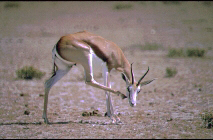
weaverbird nests, which is why it so vivid in my memory. The first sightings of game were
evident: gemsbok and springbok. We met up with the Namibian tour group again at the sandy
Sesriem campsite, Werner and colleague swapping anecdotes around the campfire that
evening. If one truly wishes to view the brightness and magical brilliance of the Milky
Way in all its magnificence, then this is a place to be to view it! That evening my long
johns and balaclava assumed their trial run.
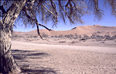
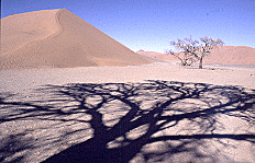
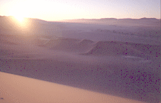
Werner woke us at 4h30 and we headed for Sossusvlei dunes in the dark. Leaving our truck besides a tree in what appeared to be the middle of nowhere, we walked across what was probably a dry river bed to the base of a huge dune several hundred metres high and proceeded to climb it. The warm clothing which protected us from the biting chill early morning air was soon discarded, as we ploughed our way through the soft red sand along the winding ridge towards the dune summit, sweating profusely. On the way up we were literally halted in our tracks as the penetrating rays of sunlight instantly popped out from behind a dune and lit a multitude of sand dunes as far as the eye could see. I removed my sandals to make climbing easier, but still felt the cold as my feet sank into the soft sand. A celebratory cheer rang out as the next individual reached the dune summit. The descent was attempted in a variety of ways, some even rolling down the smooth slope. Back at the truck, Werner had prepared breakfast, a fitting end to an exhilarating experience. The afternoon activity was somewhat more tempered and involved a quiet stroll down to the modest Sesriem Canyon, which seemed to resemble some ancient city ruin. The extreme beauty of the region is clearly evident in the multitude of shades of hue which the landscape projects. Distant mountain colours vary from pale blue through to purple, while those somewhat closer appear light brown to reddish brown and even shades of orange, at dawn or dusk. |
 |
 |
 |
|
| The calm of the previous day was in stark contrast to the windy conditions early the following morning. The route now took us through a God-forsaken world of nothingness towards the coast, although three distinctly different types of landscape emerged: the mountainous terrain of the previous day, the dark rock of the Kuiseb region and the sandy desert landscape. Travelling via Walvis Bay, renowned for its flamingos, we finally arrived at the relatively "civilised" Langstrand Campsite, even though we had to endure cold showers. I later visited a local dentist in Swakopmund, a bit of Germany in the desert, to attend to a dislodged bridge crown, thereafter stopping off for a coffee at Café Treffpunkt in Kaiser Wilhelmstraße. In the meanwhile, Christian would take leave of the tour to meet his fiancée in Melbourne. The evening was spent at the Langstrand restaurant, one of a number of pre-planned outings of the entire tour. It soon had the makings of a party of raucous proportions, which continued till well after midnight, I am led to believe. A huge table had been moved into the bar to accommodate us, or so it seemed. Johan slipped accidentally while on a midnight swim and ended up in Kathleen's sleeping bag, so she took Nic's, who ended up without one! |
|
| A number of extremely tender beings crawled out of their sleeping bags the following morning. After another visit in Swakopmund to the dentist, a late morning coffee and cheesecake, while stocking up for a proposed cheese and wine dinner for which six of us had chipped in, we were on the road again to Mile 108. |
|
|
| In reality
Mile 108 was a beach campsite, far more rudimentary than what we had become
accustomed to this early stage of the tour. The cheese and wine, a precursor
to the evening pasta meal, went down well and made up for the dismal lack of
adequate campsite facilities!
At Cape Cross a colony of hundreds of seals covered a stretch of beach, the bulls fiercely protecting their territory from any intruding seals, size or gender notwithstanding. The route still clinging to the coastline, we headed up and entered the Skeleton Coast Park gate, the carcasses an eerie reminder reflecting the desolation of the vast, flat countryside. We headed inland an encountered the hapless "Neville", an amateur tourist operator, stuck with a trailer "flat", no spares for it and a bunch of disgruntled French tourists. After an unsuccessful attempt to assist him, he was forced to headed back 50km, his trailer being abandoned in the process. After having our lunch, we met up with not 5km later and a "flat" on the Hiace! |
|
|
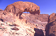
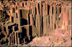
The countryside altered dramatically until we reached Twyfelfontein, nestled in more mountainous terrain, with trees in evidence. A local guide, who went by the name of Julia, took us on a tour of the Bushmen rock paintings. The Petrified Forest resembling church organ pipes and the Burnt Mountain were next on the agenda. |
| Twyfelfontein, Damaraland, site of Bushmen rock paintings & the organ pipes of the Petrified Forest |
| The Au-hab campsite bar served drinks. Some went
off to play soccer with the locals. Nic, in turn, who had developed into the resident tour
lunatic, adopted his somewhat unorthodox method of attracting attention to which we had
become accustomed, by climbing every hill in sight! As I took a shower at the bamboo
construction ablution facilities, Jo, waiting in line outside, remarked that she would be
in a position to "observe the crown jewels" should I turn around. I contemplated
this a while before I responded by enquiring as to how she could possibly know that I
would have to turn around in order for her to observe this! I elected to spend
the night in one of the Au-hab bamboo A-frame open-ended campsite huts.
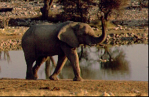
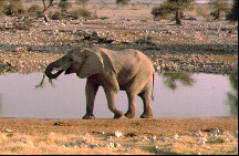
Probably the world's most unusual tree, Welwitschia mirabilis, is found in the intermediate zone between the coastal and inner Namib. Consisting of two heavy, fibrous leaves, torn into two strips by the wind, the largest specimen is over 2000 years old and six metres from tip to tip. Survival depends upon a fine network of absorbing roots, anchored by a giant taproot. We left for Etosha via Khorixas, stocking up en route at the supermarkets of Outjo at about midday. It took us two and a half hours to reach Okankeujo, where we partook of a late lunch of salad and sliced ham. Etosha consists of three rest camps, effectively sealed off from the rest of the game park. This is where the campsites, rondavels, ablution facilities, restaurant, swimming pools etc., are located. Each has a large water hole with an appropriate arrangement of seating suitable for game viewing. Okaukeujo and indeed, all the other rest camps, had changed substantially since my last visit 14 years ago. Some folk swam at the main pool. It is often at quiet periods such as this when washing becomes a matter of necessity rather than desire. Elephant had gathered at the water hole, located behind an electrified fence and stone wall, to indulge in a good, healthy mud bath. After a braai/stir fry supper and another round of the murder game, I returned to the water hole, which was now floodlit and populated with elephant and rhino. |
|
|
| We were up at 5h30 in order to head off for some game viewing by driving around on designated dirt roads through the 22,270 square km Etosha Pan. Zebra, kudu and springbok were in abundance. We returned to pack, before heading off to the next campsite at Halali, stopping en route for a group photo at Etosha Pan proper, a huge flat white salt expanse stretching as far as the eye could see, mirages dancing on the horizon in the shimmering heat of the afternoon sun. Arriving at Halali at 16h00, I went for a much-needed swim. The waterhole, located on the slopes of a hill, afforded one a magnificent sunset view. There not being much activity in terms of game, I returned and gatecrashed the committee meeting. We then had what I considered to be one the best meals of the tour - cottage pie! Back at the waterhole, some elephant, hyena and foxes graced us with their presence. In an instant birds swooped down on the waterhole, creating a chorus of cacophonous sound punctuated by the croaking of frogs. I turned in for the evening. As it turns out, all things come to those who wait; if I had remained a bit longer, I would have witnessed a troop of thirty-nine elephant! |
|
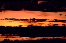
| Namutoni is located on the eastern side of Etosha, this being our final campsite stop in the game park. Encountered a dead buck near a waterhole, evidence of an earlier slaughter. The sunset was particularly beautiful this evening. Chris and co., on kitchen duty, prepared a range of mild/medium/hot chicken curries for dinner, as vivid as the skyline at dusk. |
|
|
| Up early. After a quick detour via a waterhole,
where a lion was spotted, we headed for Grootfontein. The hectic schedule of the past week
began to take its toll. Some caught some shut-eye. The music was laid-back. A good laugh
at the expense of Marku - Claus taped somebody snoring and suggested it had been him!
Despite the obvious shortage of rain, the vegetation had become somewhat denser and more
savannah in nature as we went through Grootfontein and headed north. Ovambo huts began to
make an appearance. The first glimpse of real Africa! What struck me was the fact that the
entire ground around the general area of abode was totally devoid of vegetation. Local
kids at Rundu were keen to sell their crafts and beg for money. Kayengona Lodge was
located on the banks of the Okavango River - green lawns, bamboo huts, and a bar. While
swimming in the river with Angola just across the border, it was difficult to imagine how
a state of war had existed here not too long ago. Steak and baked bread was on the menu
for dinner. Yummy! Scattered across the lawns, beer bottles containing a wick and paraffin
provided a novel method of lamp.
A thick early morning mist hung over the river. As was customary on such tours, one would not pay immediately for each and every drink ordered; instead a bar tab was kept, which usually resulted in those who had been somewhat liberal the night before in terms of, inter alia, their intake of the fruit of the vine, being somewhat shocked the next day as to what they had to cough up in order to settle the bill! Barring the last 100km of the route to Katimo Mulilo, the entire road was tarred. Construction was in progress on the gravel section. A tyre ruptured en route and lunch was had while repairs were carried out. The town centre of Katimo was a sandy square surrounded by supermarkets and other related businesses. We rushed to and arrived at the campsite on the Zambezi River just as the sun began to set. The campsite was on a lawn under a thick expanse of trees. The last of the Namibian dollars were expended on a triple Amurula and ice. Owing to the existence of crocodile, this river was definitely not conducive to swimming! The lengthy trip to Victoria Falls would take us through 6 border posts. Part of the route took us through the Chobe National Park, crossing at Ngoma and Kazungula. Game was spotted en route. It was indeed a tragedy that we were forced to rush through what is regarded as one of the finest game parks in southern Africa. A herd of elephant crossed the dusty road, the sight of the yellow Whichway truck disturbing them to the extent that the bull trumpeted his obvious displeasure. Jo's African drum was confiscated at the Botswana border, owing to the fact that the skin posed a threat to livestock in view of the existence of an epidemic. Indeed, the receipts for the purchase of our meat in South Africa kept in the on-board freezer, had to be produced. |
|
|
|
[WhichWay Adventures Tour - Intro] [Namibia] [Zimbabwe] [Zambia] [Malawi] [Tanzania] [Zanzibar] [Kenya] [Mt. Kilimanjaro] |
|
|