|
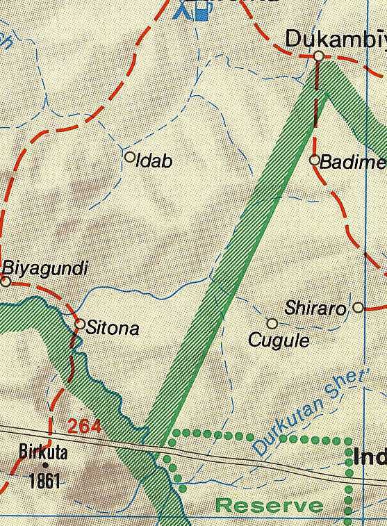
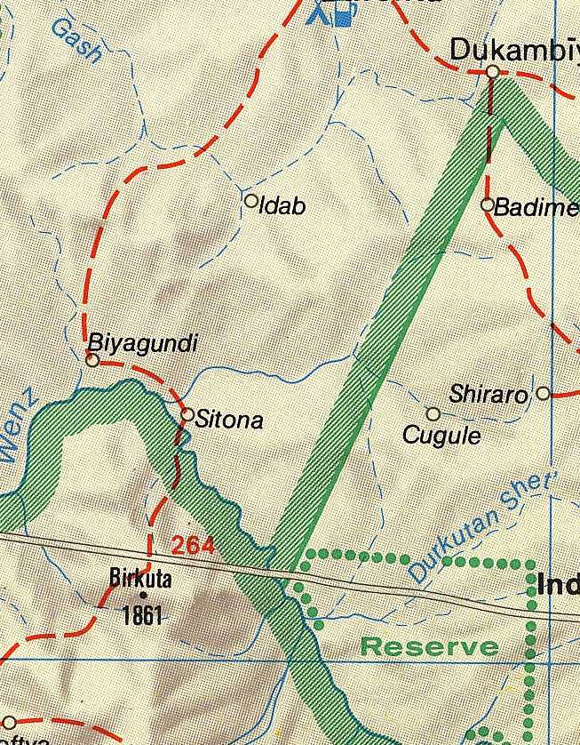
Reference/Comment: A Map Showing Badime in Ethiopia - Courtesy of Dehai EritreansFeb 20, 1999Dear Netters: The Eritrean website known as Dehai has been a focal point for the dissemination of Eritrean propaganda. But hidden in their website is a map of the Badime region showing the town of Badime located firmly within Ethiopia. Click here for the cropped Badime map or choose the larger version. This map is not displayed anywhere for readers to view, but it is stored there nonetheless at this URL: http://www.primenet.com/~ephrem2/newscom2/Badmec.JPG. I do not know where the Dehai fellows got this particular map from. I will say that I have examined a great number of maps for Eritrea and Ethiopia, and there is not a single map which shows Badime in Eritrea. There are several maps showing Badime inside Ethiopia (for example the MacMillan Atlas map), and there is one map that shows Badime right on the border. However I have not seen the Dehai map before. The Dehai administrators should inform their readers where they got that map, and how come they are keeping it hidden.
The "Straight Line" Border:The Dehai map shows a straight line border. But even with the straight line, Badime lies inside Ethiopia. In any case, there is no straight line specified in the Italo-Ethiopian treaties, and there is no legal document which assigns Badime to Italian/Eritrean sovereignty. In addition, the Italian maps (and any derivatives based on the Italian maps) draw the border in the wrong place. The treaty of 1902 ties the Ethiopia-Eritrea boundary roughly 100 km west to the Ala Tacura mountain and the Mai Teb river. These are the specific features mentioned in the treaty. The actual delimitation and demarcation was left for later (and never completed), but it is pretty obvious that final delimitation and demarcation is not going to produce a straight line.Eritrea may claim that the Treaty contains a cartographic error (an Eritrean sent me an e-mail on this topic), however this is false. Mt. Ala Tacura is a prominent, unmistakable feature in the Gash -Setit region, and the location of the Mai Teb river is confirmed by the still-existing Mai-Teb village located adjacent to it. The same Eritrean e-mail suggests that "it was later agreed" that the 1902 Treaty was in error. But no one has been able to produce this so-called "agreement." In fact, no such agreement exists. The truth is the opposite. In the period 1908 to 1935, Ethiopia was vigorously protesting Italy's violation of the 1902 Treaty in the Gash-Setit region. The Eritrean government is fully aware of this and has in its possession the relevant Italian colonial documents that explain the history of the border issue. However, it is keeping this information hidden. We do not know what Eritrea's legal strategy will be, but in any case, Eritrea needs to find a way to "re-interpret" the Italo-Ethiopian Treaty of 1902. Otherwise it is guaranteed to lose any claim on Badime during arbitration.
-Dagmawi
Notes: (1) I have rotated the image so that the north is pointed up, and I have also reduced the graphic density so that the image loads faster. If you visit the Dehai URL you will see that it is a huge graphic file and oriented the wrong way. (2) Click on the link for a map showing the distribution of the Kunama ethnic group in 1903. This map shows how the border was supposed to look. (3)It should be remembered that the 1902 Treaty was a tripartite treaty where Ethiopia, Great Britain and Italy exchanged limited territories of roughly equal size amongst each other. The Treaty was not intended to be an open-ended tool for Italian expansion - it was not a one-way grant of territory to Italy from Ethiopia.
Attachment The treaty of 1902. His Majesty the Emperor of Ethiopia, Menelik II, Major Ciccodi cola, Italian Minister in Ethiopia, and Lieutenant-Colonel Harrington, His Britannic Majesty's Agent in Ethiopia, have mutually agreed that :- Frontier Between Ethhiopia and Eritrea Art. I.-The frontier Treaty between Ethiopia and Eritrea, pre viously determined by the line Tomat-Todlue, is mutually modified in the following manner Commencing from the junction of the Khor Um Hagar with the Setit, the now frontier follows this river to its junction with the Maieteb, following the latter's course so as to leave Mount Ala Tacura to Eritrea, and joins the Mareb at its junction with the Mai Ambessa. The line from the junction of the Setit and Maieteb to the junction of the Mareb and Mai Ambessa shall be delimited by Italian and Ethiopian delegates, so that the Canama [Kunama] tribe belong to Eritrea. Frontier Between Sudan and Eritrea Art. II.-The frontier between the Sudan and Eritrea, instead of that delimited by the English and Italian delegates by the Convention of the 16th April, 1901, shall be the line which, from Sabederat, is traced via Abu Jamal to the junction of the Khor Um Hagar with the Setit. The present Agreement shall come into force as soon as its ratificition by the British and Italian Governments shall have been notified to the Emperor of Ethiopia. In faith of which His Majesty the Emperor of Ethiopia, Menelik II, in his own name and that of his successors; Major Ciccodicola, in the name of His Majesty Victor Emmanuel III, King of Italy, and his successors; and Lieutenant-Colonel Harrington, in the name of His Majesty Edward VII, King of the United Kingdom of Great Britain and Ireland and of the British Dominions beyond the Seas, Emperor of India, and his successors, have signed the present Note in triplicate, written in the Italian, English, and Amharic languages identically, all texts being official, and have thereto affixed their seals. Done at Adis Ababa, this 15th day of May,, 1902. (L.S.) JOHN LANE HARRINGTON, (Seal of His Majesty, the Emperor Menelik II.) |