

Cape of Good Hope Colony (usually called Cape
Colony)
Colonie Kaap de Goede Hoop
“Hope” crest / motto “Spes Bona” / fleur-de-lis / Cape triangular stamp / supporters’ tails / Eastern Province / Great Trek / British Kaffraria

Arms granted by Royal Warrant on 29 May 1876, and recorded by Garter King of Arms at the College of Arms on 28 June that year. The full text and an illustration were published in the Cape Government Gazette in September 1876. The blazon reads:
Arms: Gules, a lion rampant between three Annulets Or, on a Chief Argent as many hurts each charged with a fleur-de-lis of the second, for the Crest – on a Wreath of the Colours the Figure of Hope proper vested Azure resting the dexter arm on a Rock and supporting with the sinister hand an anchor sable entwined with a Cable also proper, and for Supporters – on the dexter side a Gnu and on the sinister side an Oryx (gems buck) both proper, together with the motto “SPES BONA”.
Arms explained:
The central charge of a lion is appropriate for several reasons. Firstly, the lion (Leo leo) is indigenous to South Africa – indeed, a subspecies, the black-maned Cape lion (Leo leo capensis), had been endemic to the colony until it was hunted to extinction in 1842 (the last lion in the Cape Colony, shot near Colesberg).
Lions also appear in the arms of England and Scotland (see Great Britain), the Principality of Wales (see the arms of Prince Charles), the Kingdom of the Netherlands and several of the Dutch provinces.[1] This lion has the posture of the lions of both Scotland and the Netherlands, and the colouring of the lions of England. Settlers at the Cape had come from all these countries.
The annulets are taken from the family arms (gules, three annulets or, 2 and 1) of Jan van Riebeeck, founder of the Dutch settlement of 1652 which had grown to become the Cape Colony. They are found also in the arms of Cape Town. While an annulet is called a “ring” in Afrikaans and Dutch, the term ring is reserved in English heraldry for a metal ring with a stone set on it.
The term “hurt” means a blue roundel. The fleurs-de-lis[2] are taken from the arms of the kings of France, and symbolise the French Huguenot refugees who settled at the Cape, especially those who arrived through a subsidised settlement scheme from 1688 onwards. The heraldic rule forbidding placing tincture next to tincture made it irregular (according to the 19th-century heralds) for the entire chief to have the blue colour of the French kings’ arms (because the field is red), so hurts were adopted as a means of introducing blue as a background for the gold fleurs-de-lis.
When the Canadian province of Quebec adopted a coat of arms in 1868 a similar problem arose because the (two) fleurs-de-lis in the chief were immediately above a red fess bearing a lion of England. The solution found by the heralds of the College of Arms was to reverse the colours of France, making the fleurs-de-lis blue on a gold field (the base, below the fess, was also gold).
However, the Quebecois found this objectionable and in 1938 persuaded the heralds to permit the chief to be blue (with three gold fleurs-de-lis) alongside the red fess, so changing the arms from a red fess on a gold field to a field tierced in fess, the field colours then being (from top to bottom) blue, red and gold. This solution was not, however, sought by either the Cape Colony or its successor, the Cape Province.
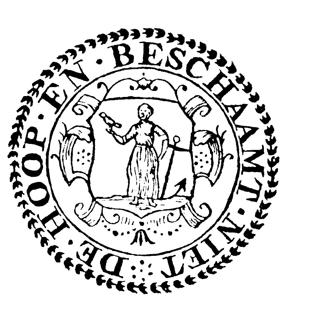
The crest is derived from the seal (not always a heraldic device) of the Groote Kerk in Cape Town, the oldest congregation in the country of the Nederduitsche Gereformeerde Kerk (Dutch Reformed Church) – in the early years of the colony, the only church of any kind. There are several examples of this seal – the one shown here dates from the 17th century.
All of them showed the allegorical figure of Hope, represented as a virgin, holding an anchor. In this version (where she appears within a shield) she also has a dove of peace on her hand and the wording “De Hoop en beschaamt niet” (“Hope does not disappoint”). In later (unheraldic) versions she stands on the shore of Table Bay – a parallel with the official seal of the colony from 1827 to ’76, which is a picture of Table Mountain with shipping in the bay. This theme remained in the synodal seal of the Nederduitse Gereformeerde Kerk of the Cape Province.
The Dutch took over the name of their settlement from the Portuguese (although the Portuguese never had any kind of settlement at the Cape, and called Table Bay “Bahia de Saldanha”).
For a long time the Dutch called the settlement “Cabo” or “Caab” (see below for the naming of the Cape of Good Hope), but added to its symbolism through the use of the allegorical virgin, one of the three “sisters” popular in Renaissance art representing the traditional virtues of faith, hope and charity. The virgin always held an anchor, being the symbol of faith.
The symbol was not only used by the Groote Kerk, but was generally regarded as a symbol of the colony. A virgin with an anchor was used as a hallmark for Cape silver. Being a virgin, she could also easily be confused with “the Virgin”, Mary, mother of Christ.

This virginal figure was the inspiration for the artwork of Charles Davidson Bell, Surveyor-General of the Cape, when he designed the colony’s first postage stamp, the celebrated Cape Triangular, which was first issued on 1 September 1853. It was the world’s very first triangular stamp, and the first stamp issue by any country in Africa.
Bell’s artistry in using the triangular space available resulted in Hope’s being seated on a rock, and after this a rock was an inseparable part of the design. Stamps of this design were in use for 11 years, after which it was replaced by other designs also showing the figure of Hope. The one shown here is almost the same as that of 1864, but was issued in ’71. Variations on this theme continued in use until 1902, when the head of King Edward VII replaced the figure of Hope.


The crest retains the rock, but shows Hope standing. A religious aspect is maintained, however (albeit in concealed form), since the rock and the anchor are both symbols of Christ in religious imagery. (It is interesting to note, but wholly unconnected with the NG Kerk, that the Roman Catholic Church has declared the Virgin Mary to be the patron saint of South Africa.)
The dexter supporter is a gnu or black wildebeest (Connochætes gnou), also called the white-tailed gnu. This species was once extremely common in the wild, but came close to being extinct in the 20th century and has since been re-established through the efforts of South African conservationists. This animal also appears in the arms of Natal.
The sinister supporter is an oryx or gemsbok (Oryx gazella gazella). This desert animal is a race or subspecies of the animal also known as Arabian oryx (Oryx gazella leucoryx), scimitar-horned oryx (Oryx gazella dammah) or beisa (Oryx gazella beisa). The gemsbok is the Southern African variety, and is still to be found in the wild in the north-western and northern parts of what was the Cape Colony. Both animals were portrayed with their tails in the downward or coward position. This is not, in fact, the way the arms were originally devised by Cape Town attorney Charles Aken Fairbridge, who – following heraldic tradition – drew the tails up. P R Coates writes: “However the public at the Cape were well aware that such beasts only curved their tails upwards in certain specific circumstances. Colonial propriety was offended, and a variant of the coat of arms with decently drooping tails was quietly adopted.” He continues: “Astonishingly, both these versions of the Cape’s coat of arms continued to be used, presumably depending upon the barometer of public prudence from time to time. Thus the public estimates from 1894 to 1903 were tails down, but 1904 to 1907 tails up; the Statutes of the Cape of Good Hope were tails down for volumes 1 and 2, tails up for volume 3, the Provincial Ordinances 1945 to 1951 were tails down, but 1963 to 1986 were tails up; the Official Gazette was tails down from 1928, but tails up from 1952 until it appeared for the very last time on 26 August 1994.” The change in the second half of the 20th century was largely due to the fresh drawing prepared for the Cape Province. Coates notes that the supporters in the arms of the Western Cape Province are “both with tails daintily lifted”. The Latin motto, Spes Bona, recalls the first naming of the Cape of Good Hope in 1488 (see Western Cape for a detailed derivation). Background to arms: It was intended that the arms would be placed in the fly of the Blue Ensign, so serving as the flag of the colony, rather than as a British flag. This intention was in accordance with the British Parliament’s Merchant Shipping (Colours) Act of 1864 and Colonial Defence Act of 1865, which provided for colonial vessels to fly distinctive versions of the Red or Blue Ensigns “with the seal or badge of the Colony in the fly thereof”. A flag of this sort had been in use in Canada since 1868. However, the Governor of the Cape, Sir Henry Barkly, was unwilling to allow modifications to the Union Jack and its related flags. He took his lead from a circular dated 23 February 1875 from the Secretary for the Colonies, Lord Carnarvon, which pointed out that versions of the Union Jack with colonial arms in the centre were solely for the use of colonial governors when afloat. He was unwilling to give his permission for the flag – either the Union Jack or the Blue Ensign – to be used for any other purpose. Fortunately for the organisers of the foundation stone laying, Sir Henry gave in after representations had been made to him, and he permitted the use of flags – a Union Jack as well as a Blue Ensign – bearing the colonial arms, fully a year before the arms had officially been granted. One variation on these arms was produced during the life of the Cape Colony. This was in the Great Seal of King Edward VII (reigned 1901-1910), where the crest was replaced by a radiated Tudor or Imperial State Crown. The change is explained by reference to the British royal arms, which occasionally appear in abbreviated form with a crown instead of a crest. This version disappeared after the King’s death on 6 May 1910 and played no further role in the history of the arms. Languages: However, where Dutch was used, it retained a form of official status. It was the principal language preached in the NG Kerk (where Afrikaans was not used, but English occasionally was), which until 1875 shared the status of State Church with the Anglican church, and it was used in private, but not public, education. More especially, Netherlandic-speaking colonists asserted the right to speak Dutch in the Cape Parliament during the period of responsible government, which began in 1872, and in 1882 “Onze Jan” Hofmeyr won the right for Dutch to be used in Parliament. In 1883 knowledge of Dutch became compulsory for a certain class of civil servant, and in ’84 it was permitted in the higher courts. In 1887 it became a compulsory subject for civil service candidates – although while Dutch was permitted, it was “not enforced with any degree of conviction”.[3] Colony’s history: Early intentions to limit the size of the colony were constantly overcome by a variety of factors, and when Great Britain sent an expedition to seize the colony in the name of Willem V, Prince of Orange, in 1795 – to prevent the strategic possession from being seized by revolutionary France – it already extended from the Cape Peninsula to a disputed border east of Algoa Bay (which, after a number of clashes, was fixed on the Fish River) and northward to the (normally dry) Buffels River, just south of the Copper Mountains in Namaqualand. Dutch rule returned briefly in 1803, following the Peace of Amiens, and the Batavian Republic took control for a brief three years until Britain again seized the colony in 1806. In 1814, with the consent of Willem VI, Prince of Orange (created King of the Netherlands the following year), the Congress of Vienna allowed Britain to keep the Cape permanently. The eastern parts of the Cape Colony had two periods of relative separation from the rest of the colony, both of them under the same man, Andries Stockenström. Stockenström, who had served some years as landdrost of Graaff-Reinet (and was the son of the Swedish immigrant Anders Stockenström, also landdrost of Graaff-Reinet in his time) was in 1828 appointed, following the abolition the previous year of the office of landdrost, Commissioner-General of the Eastern Districts. This position authorised him to negotiate with indigenous rulers beyond the colony’s borders. He resigned in 1833, and left the colony for Europe. But in February 1836 he was appointed Lieutenant-Governor of the Eastern Province of the Cape Colony (a territory covering the same districts as he had previously controlled). (One other man was actually appointed Lieutenant-Governor of the Eastern Province: this was Major-General Richard Bourke, who arrived in the colony in 1826. However, he did not take up residence in the eastern districts; the departure of Governor Lord Charles Somerset only a month after Bourke’s arrival meant that he took charge of the colony and remained in Cape Town.) A decade after his dismissal in August 1839, Stockenström was rewarded for his services with a baronetcy. While the so-called Eastern Province was not again separated from the western half of the colony, its brief period of separation was the inspiration of a separatist movement in the eastern districts that continued for several decades but eventually came to nothing. The region is today the western half of the Eastern Cape Province. The names Eastern Province and Western Province have nonetheless remained in popular usage, especially in the sporting associations based respectively in Port Elizabeth and Cape Town and the military commands based in those cities. In 1835 and ’36, tensions between the Boer population on the eastern frontier and the British authorities reached a head, and thousands of Boers left the colony to take part in what has since been called the Great Trek, initially travelling to Thaba Nchu in what became the Oranje Vrij Staat. A number of them crossed the Drakensberg range to where the Republiek Natalia came into being, before Britain annexed that state as the Colony of Natal in 1842. Others trekked further north into what became the Zuid Afrikaansche Republiek. No overall figure is given for the emigrants, but it is estimated that by the early 1850s, there were 15 000 Boer inhabitants in the Oranje Vrij Staat and 20 000 in the ZAR. With the creation of the district of Colesberg in 1830, the colony’s borders reached the Orange or Gariep River, and the border was temporarily extended to the Kei River. In 1847 the (north bank of the) Orange River became the border right down to the sea, and in ’48 the separate colony of British Kaffraria (between the Fish and Kei Rivers and as far as the Amatola [Amathole] mountains north of Stutterheim, with King William’s Town as its capital) came into being. This colony was annexed to the Cape Colony in 1866. Further districts (outside the Transkeian Territories) were added along the upper Orange River (beginning with Albert [Burgersdorp] in 1848) and the Drakensberg range until 1881. The Cape Colony attained self-government on 30 June 1853, when its first elected Parliament was inaugurated. Responsible government followed in December 1872, when John Molteno became the colony’s first Prime Minister. In 1867 the discovery of diamonds along the Orange River led to an unprecedented rush of speculators into an area north of the river that had several claimants. Arbitration by the Lieutenant-Governor of Natal, R W Keate, awarded the disputed land to Griqua chief Nikolaas Waterboer, who immediately placed himself under British protection. His territory became, in 1871, the colony of Griqualand West, which was annexed to the Cape Colony in 1880. (For more on the dispute, see this page.) In 1878 the Walvis Bay territory (1 124 km2) was annexed by Britain; it became part of the Cape Colony in 1884. In 1892 it became an “island” in German South West Africa, but remained part of the Cape. In 1879 Fingoland (including the settlements of Butterworth and Idutywa) was annexed to the Cape. Also annexed was the territory called Griqualand East, which had been settled by Griqua under Adam Kok III who had trekked across the Drakensberg from the southern Oranje Vrij Staat. In 1882 Boer freebooters established the short-lived republics of Stellaland and Goshen to the north of Griqualand West, in contravention of the Pretoria and London conventions by which the Zuid Afrikaansche Republiek had regained its independence. A British expedition under Sir Charles Warren the following year suppressed the two republics and annexed all the territory west of Griqualand West and the ZAR, south of the Molopo and Nossob rivers and north of the Orange River as the Crown Colony of British Bechuanaland. This became part of the Cape Colony in 1895. (See North-West Province.) Also in 1884 the Cape Colony and Natal simultaneously annexed the estuary of Port St Johns on the Mzimvubu River, which Natal later conceded to the Cape. Other Transkeian territory was annexed in the following decade: Tembuland, Bomvanaland and Galekaland (land of the abeThembu, amaBomvana and amaGcaleka, all west of the Mthatha River) in ’85, the Mount Ayliff district in ’86 and Pondoland (home of the amaMpondo and their cousins the amaMpondomise) in ’94. During 1909 the Cape Colony participated in what was called the National Convention – talks with the Natal, Transvaal and Orange River colonies (with observers from Rhodesia in attendance) with a view to forming a federation or union. These resulted in the passage of the South Africa Act (1909) by the Westminster Parliament, which paved the way for the Union of South Africa’s coming into being on 31 May 1910. The Cape Colony now became the Cape Province. [1] For more detailed information on the British royal arms, see this page. [2] For the most likely derivation of the fleur-de-lis, see this page. [3] Quoted from The Afrikaners: Biography of a People, by Hermann Giliomee (Tafelberg). Back to colonies and republics index Comments, queries: Mike Oettle
C A Fairbridge had been asked to prepare a design suitable for use at the laying of the foundation of the foundation stone of the colony’s new House of Parliament (in part of the Dutch East India Company’s Garden in Cape Town) on 12 May 1875.
At the top of this page the colony’s name is given in both Dutch and English. This is not because the two languages had equal status, since during the period of British rule, and especially after the Congress of Vienna ruled in 1814 (with the assent of the Kingdom of the Netherlands) that British rule at the Cape should be permanent, English was the sole language of the courts and of administration.
The colony at the Cape of Good Hope was founded by the Dutch East India Company (Vereenigde Oostindische Compagnie), which in 1651 sent ship’s doctor Johan van Riebeeck as Commander of what was intended to be no more than a refreshment station. His party arrived in Table Bay (see Cape Town) on 5 April 1652 and landed the following day.

Vir Afrikaans, kliek hier