GeoCities.com/
Invizzible
Hamlin's Online Reporter
Invizzible - Actual charicature of me, January 2002 Paul Stalter, Webmaster
Bringing Mason County
to your fingertips!

My unique and exclusive presentation, including satellite images and aerial photos, of Hamlin Township.

Satellite Images Start Page

Hamlin Lake
State Park Dam
State Park Outlet
Big Point Sauble Lighthouse
Carferries of Ludington
Pumped Storage Project
Sargent Sand Company
Epworth Heights

Mason County Airport
Dow Chemical
Train Depot

Ludington High School
Oriole Field
Nordhouse Elementary

Jebavy Bridge
Lincoln Bridge
Victory Park

Partridge Pointe
Laman's Landing
Sauble Resort
Barnhart's Resort
Tamarac Community

Pentwater
Bass Lake

Assorted

My Neighborhood
Heart of Hamlin Township
My House
Impact Crater
My Mile of Jebavy
Hamlin Township Hall
Hamlin Township Fire Department
Hamlin Grocery

Oddities
Visible only by satellite
Impact Crater
Peace Symbol
Terrestrial Navigation

Hamlin Township - Ludington - Mason County, Michigan
Sitemap Big Sauble Point Lighthouse Contact
The Big Sauble Point Lighthouse at the Ludington State Park
Image courtesy of TerraServer.

Called Grande Pointe au Sable by French explorers and traders, Big Sable Point was an important landmark for mariners traveling a treacherous stretch of Lake Michigan shoreline between Big Sable Point and present-day Ludington. In 1855 twelve ships wrecked in that area. Commerce linked to the burgeoning lumber industry required Big Sable Point be suitably lighted. State Senator Charles Mears pressed the legislature to ask the federal government for a light station at Big Sable. In 1866 the U.S. Congress appropriated $35,000 for a lighthouse, which was built the following year. As the lumbering era waned, steamers carrying coal, food and tourists continued to rely on the lighthouse for navigation.


The Big Sauble Point Lighthouse was constructed in 1867 with a tower measuring 112 feet. In 1902, 35 years later, the brick tower, then deteriorating, was encased in steel. The keeper's dwelling, which was once a single family housing, has been enlarged over the years, evolving into the present three-family residence. Indoor plumbing, heating and a diesel electric generator were added in 1949. In 1953 power lines were extended to the Point. In 1966 the tradition of light-keeping, which began in 1867 by Alonzo A. Hyde and his wife Laura, ended when the station was fully automated. Big Sauble Point Light Station is listed in the National Register of Historic Places. Satellite image of Big Sauble Point Lighthouse
Image courtesy of TerraServer.
People often ask me why, when I refer to the lighthouse, I spell it Sauble one time and Sable the next time. Even though I risk getting nasty e-mails from people who insist on one spelling over the other, I'd like to point out that either spelling is correct. While doing research for this page, I got just as many search results by querying either spelling. Even historians spell it both Ways.


Photo Gallery
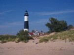
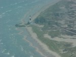
Big Sauble Point Lighthouse
Photo Credits: D. Vandervelde, 8/25/2002.
Big Sauble Point Lighthouse
Spiral stairway looking up from the bottom
Lens structure
Spiral stairway looking down from the top
Views From the Top
A View From Above
A View From Above
A View From Above
A View From Above
A View From Above


Big Sauble Lighthouse Aerial Photos
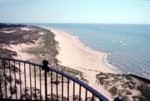
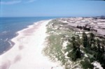
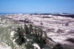
Photo Credits: Peggy Sue Swiecki
Visit Peggy Sue's WebShots gallery!
Big Sauble Point Lighthouse

Related Page: Ludington State Park Dam


How does my site rank with other Mason County websites?
Google, courtesy of Geocities.com/Invizzible
Search WWW Search Yahoo!

Use my Google search box to search Hamlin Township, Ludington, or Mason County!

(Example: Epworth Heights, Hamlin Lake, Sargent Sand, Ludington Pumped Storage Project)

Design and Graphics Copyright © 2000, 2001, 2002, 2003, 2004 Invizzible PC. All Rights Reserved.