A member of GeoRewards
This site has a U.K. mirror here. Angelcynn At West Stow Anglo-Saxon Village
On September 13th & 14th 1997 Angelcynn put on a small event at West Stow Anglo-Saxon Village. On this page you will find information about the Anglo-Saxon village of Stowa and it's modern reconstruction and images of Angelcynn at the Village.
(Click on image for a closer look)
The Event.
Dateline 620 AD, the East Anglian Supremacy
The first quarter of the seventh century was an important time for East Anglia. It's inhabitants were starting to be converted to Christianity by missionary monks, and it would not have been uncommon to find mixed populations of Christians and Pagans living side by side. During this time East Anglia rose to become the Dominant kingdom of England, under King Redwald. At this time, throughout England there were major political, economic and religious changes occuring. England was no longer a place of small insignifacant kingdoms, but a part of a wider European culture. The Sutton Hoo treasure shows what a cosmipolitan world the powerful East Anglian kings and nobles were living in. The shield and helmet were Swedish (and probably the king's ancestors too). The great silver dish came from Constantinople (modern Istanbul); a bronze bowl from Alexandria in Egypt; Coins from Merovingian Gaul, the hanging bowl perhaps from Ireland. Although the ordinary freeman might not have known much of this luxury, it was certainly a time of prosperity for the East Anglian people.
Redwald, King of East Anglia
Redwald was the king of East Anglia from before 616 until his death in about 625AD. According to Bede, from 616 (the date of the death of Æðelberht of Kent) he was the fourth English ruler to exercise overlordship over all the Anglo-Saxon kingdoms south of the Humber, or to use the Old English word, he was the fourth Bretwalda. In 616 he defeated and killed Ethelfrith of Northumbria and thereby assisted Edwin, whom he had sheltered as an exile, to become the Northumbrian King. Redwald had been converted to Christianity, apparently at the court of Æðelberht of Kent, but on his return to East Anglia had been led away from the faith 'by his wife and certain evil teachers.' Bede tells us that in his temple at Rendlesham he set up a Christian altar alongside a pagan one! For him it seems, Christianity meant the acceptance of an additional god, not the abandonment of his ancestral heathen ones, a not uncommon phenomenon in barbarian 'conversions' of the early Middle Ages.
It is likely, though not certain, that it was Redwald who was interred in the magnificent ship-burial at Sutton Hoo, discovered in 1939.
A reconstruction of the helmet from the Sutton Hoo Ship Burial which probably belonged to King Redwald (Click on image for a closer look)
West Stow Anglo-Saxon Village
(Click on image for a closer look)
The Setting.
The river Lark, moving lazily through water meadows from Sicklesmere to the Fens in Mildenhall, has provided man with ideal habitation sites from the very earliest periods. By the time of the Anglo-Saxon settlement early in the 5th century A. D., much of the valley must have been under cultivation by Romano-British peasants, so that the Anglo-Saxons simply took over a landscape that had already been managed for hundreds of years. A different economic pattern, however, was established by the newcomers who lived in small villages, largely self-sufficient for most things, and for whom markets and towns were quite unknown.
The excavation.
The West Stow site was discovered by Basil Brown, the indefatigable field archaeologist of the 1930s to 60s, by fragments of pottery thrown up by rabbits on the heath. It became clear that the site, a low knoll of some 5 acres in extent, was covered with prehistoric, Roman and Anglo-Saxon pottery. The threatened destruction of the area prompted the Ministry of Works to fund an excavation, which took place between 1965 and 1972. In the event, the whole site was stripped and excavated, so that for the first time in England we have an entire Anglo-Saxon village to study.
The extensive Mesolithic, Iron Age and Roman sites beneath the Anglo-Saxon village provided an added bonus not less important for East Anglian studies.
The site proved an excellent choice for excavation as it was found that the entire knoll had been covered by a sand dune deposited in the 13th century, so that apart from ploughing in the medieval period, the site had lain virtually undisturbed under a thick protective blanket of sand and, as a result, the state of preservation of much of the material is very good.
After eight seasons' work on the site, enormous quantities of potsherds, animal bones and objects were recovered and large numbers of post-holes, ditches, pits and house sites excavated and recorded. The detailed analysis of the objects and features has enabled the plans of the different phases of occupation to be disentangled and understood.
The site was occupied from the early fifth century to the beginning of the seventh and during that period the pits and post-holes, ditches, huts and hearths of the Anglo-Saxon period can be seen to have covered most of the hill with only the north-west corner sparsely occupied. When these features are looked at in detail, certain patterns can be discerned.
(Click on image for a closer look)
There were two main types of building on the site. Firstly there were the larger, rectangular buildings with the walls present as post-holes. Normally these were simple buildings about ten or twelve metres long, with a door in the south side and a central hearth. Seven post-built structures of this kind were found, five along the main east-west axis, and one on the north slope. It is thought that these buildings were in fact family halls, the focal point of family groupings on the site, each one surrounded by a number of smaller buildings. In one of these buildings there was an internal division making a small chamber at the east end and a more complicated series of posts along the sides. This, and the fact that the building occupied the central position on the site, suggests that it was, in some way, more important than the others.
A general view of the village. (Click on image for a closer look)
The small satellite buildings form the second type of building on the site and are well known all over England from the first two centuries of the Anglo-Saxon age. The traces surviving in the ground consist of a rectangular pit some four metres long, normally with one, or three, post-holes at each end. In the past they have been thought to represent pit-dwellings, dwellings of the most awful squalor (as indeed our Victorian historians thought of most of our prehistoric or 'primitive' fore-fathers).
The excavations at West Stow brought together a number of pieces of information which suggest that these buildings were much more complex than a mere hole in the ground covered with some form of bivouac roof. The evidence for planked floors, walls and clay-based hearths shows that the hole or pit was floored over and that these small buildings had above-ground walls and were quite substantial. The pit could have been put to a number of uses, for example storage, or simply under floor ventilation in the shallower cases. The material found in these pits, representing the rubbish accumulated over some 50 years of occupation is believed to be contemporary with the life of the building. This rubbish, silting through the floor and occasionally dumped in the pit, helps to date these structures and to determine the various uses to which they were put. Some were clearly used as dwellings, others for storage or weaving. In some there was evidence that the family pig had been kept tethered to one of the posts.
(Click on image for a closer look)
Sixty-eight of these smaller buildings were found and have been arranged in a chronological order by the objects and pottery found in them. From this it can be seen that they form groups round the larger, post-built structures, strongly suggesting that the whole group was a family unit with a 'hall' as the focal point with living quarters and workshops around it.
(Click on image for a closer look)
Furthermore over the two centuries of occupation on the site, the pattern of rebuilding can be discerned and from this one can say that there were only three or four families living there.
(Click on image for a closer look)
Everyday life.
A large number of pottery fragments and objects of all kinds were recovered which illustrate the daily life of the villagers. Fortunately the soil in the huts, ditches, pits and the original buried topsoil, was not acid so that the bone objects are astonishingly well preserved. Many of the bone tools, particularly the pins, are highly polished with use, looking like the bodkins in grandmother's workbox. However, not a single artefact of wood survived in the settlement, although one must suppose that there must have been many objects made in this material, such as platters, bowls, handles, boxes, furniture, buckets, barrels, carts and ploughs. The cemetery, excavated in the 1860's, does provide rare evidence of high quality workmanship in wood, with remains of two bronze-bound, wooden stave-buckets. As with house building techniques, we must remember that these settlers, coming as they did from northern Europe, had many generations of wood-working traditions behind them.
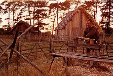
Offa the Ceorl at work on a pole-lathe. (Click on image for a closer look)
Other crafts can be identified. Over 100 combs were found in the excavation, made of bone and antler, and constructed like a sandwich, with the tooth-plates between flat connecting plates, all riveted together. Unfinished blanks and roughed-out sections of bone found in the settlement show that these finely made objects, involving the use of drills, saws, rivets and compasses were made in the village. A number of the combs are so similar in style and detail that we can suggest that they were made by the same craftsmen.
Weaving was another village craft. Large numbers of sheep were kept, which must have supplied considerable quantities of wool which was woven on upright looms into twills.
Spindle-whorls made of clay, bone and broken potsherds and bone weaving pins were plentiful on the site and it seems very likely that woollen cloth was exported in exchange for glassware, beads and fine brooches. By the seventh century occasional exotic objects such as giant cowrie shells from the Red Sea or bronze bowls from Coptic Egypt were reaching the area. One such shell was found in a rubbish pit at West Stow.
Other activities for which there is little evidence, can be inferred. For instance, the cattle, if not the sheep and goats, would produce milk and dairy products as well as leathers and meat. The iron rim of a drinking horn was found in one of the huts.
(Click on image for a closer look)
Pottery, to judge from the large number of fragments found, was important to the community for storage, cooking and as water containers. At this time all the pottery was hand-made, pinched or coiled and fired under bonfires rather than in kilns. The vast majority of pots were plain but some 5% were decorated, with simple lines, stamps or pinched (rusticated) ornament. The pottery in the settlement was fairly hard and usually burnished, both inside and out. The earliest pottery styles are very similar to those in the continental homelands, in the area of the Elbe-Weser, near Hamburg (Saxons), and southern Denmark, the home - land of the Angles. Bronze was used for brooches, pins, buckles, fittings on buckets and fasteners on clothing.
Knives, weapons, saws, drills and other tools were forged from iron. It is interesting to note that no large metal objects were found. This suggests that scrap metal was re-cycled, and there is evidence of smithing on the site in the form of iron slag, although no one particular place could be identified as a smithy.
(Click on image for a closer look)
The Economy.
The village was largely self-supporting, any excess wool, grain or hides being exchanged for fine brooches, beads, glass or strange shells.
(Click on image for a closer look)
There were no wells, for water could easily be drawn from the river, and no boundaries between properties; at least not until the 7th century. From the surrounding fields came wheat, barley, oats and rye, and a single pea has been found, hinting at other crops. The river provided fish and wild fowl, the low meadows were used for cattle, and the high dry area of their territory grazing for sheep. Pigs were kept in the woodland which also provided the occasional deer and wild fruits in season. Hens, geese and goats were kept in the village, along with dogs and cats. There were no cattle-sheds, for the mild climate enabled them to be kept outside during the winter.
Ymma feeds the chickens. (Click on image for a closer look)
Death and Burial.
The dead were normally buried in the cemetery, some 300 metres away, with their clothing and possessions. This cemetery was explored over 100 years ago and the objects sent to various museums. A freeman might be buried with a spear and a shield, or a spear only, the women with brooches, beads and occasional purse or symbolic 'keys'. Lower down the social scale the poorest were buried with a knife or often with nothing at all. Child mortality was high, especially in the very young, but adults might well reach 40 years of age. Occasionally the dead were cremated and the ashes placed in pots. We do not know what prompted this method of burial or for whom it was reserved, but most cemeteries in the Lark valley contain a few cremations.
Origin and development of the settlement.
The nature of the settlement of the Anglo-Saxons and the fate of the local Romano-British peoples is one of the most puzzling and interesting problems of the period. Although there is some evidence to suggest that Anglo-Saxons and others were invited into Britain to support and replace the regular Roman army, there is nothing to show how this applied to our immediate area.
In the evening the warm fire of the hall is very inviting......... (Click on image for a closer look)
From what we know of the surrounding areas in late Roman times, with Icklingham an important centre with a rich Christian church, it is clear that the Anglo-Saxons moved into an environment already cultivated, so that field systems, woodlands and lanes were established and managed. The settlement at West Stow seems to have been, from the beginning, self-sufficient and successful.
Come closer, join us in the hall....... (Click on image for a closer look)
Some brooches and other objects suggest that people from the Dutch coast and the Rhineland were involved in the migration of the Anglo-Saxons to Britain in the early 5th century. The population at West Stow is likely, then, to have rather mixed origins with Angles and Saxons as the basis but with a few Frisians and Franks, as well as surviving Romano-British peasants from the surrounding area.
Don't stay outside, come on in........... (Click on image for a closer look)
Our small village of three or four families was established at least by 450 A.D. and abandoned (gradually) by 750. Its name Stow (Stowa in Domesday Book) means simply ,place'. The West was not added until c. 1254 probably to distinguish it from another Stow (Langtoft) in the same hundred.
Inside it is warm and welcoming. (Click on image for a closer look)
There is some evidence for social organisation: one hall was slightly larger than the others; one person had a sword (probably a thane); the rest were freemen and slaves.
(Click on image for a closer look)
Over the two centuries that follow its establishment, the settlement seems to have remained fairly static in size, the family groups moving over the hill top as the necessity for replacing houses dictated. There were no property boundaries between the groups until the very last phases of the settlement, in the beginning of the 7th century. The village was not defended in any way but was open to the fields.
(Click on image for a closer look)
At the end of the 6th century and in the early decades of the 7th, the settlement at West Stow began to change. For reasons at present not fully understood, the family groups began to drift away from the old site and to re- establish themselves on at least one new location at the east end of the parish, not far from the later Norman church.
(Click on image for a closer look)
Although we do not know the cause of this abandonment of the site the same movement can be seen in many other Early Saxon settlements and must be related in some way to the political, economic and religious movement of the times. The 7th century saw great changes in all three fields: the consolidation of kingdoms, recognisable from the late 6th century; the foundation of towns (Ipswich) and the explosion of trade and distribution; the Christian mission and the establishment of an organised church and monasteries. The rural settlements were, no doubt, affected by all these factors.
The Lark Valley.
The pattern of settlement in the Lark Valley in the Early Saxon period suggests that the land was divided up between small villages in the 5th century and it is likely that those divisions still persist today as parish boundaries. In some cases (Wordwell for instance) later parishes can be seen to have been carved out of the older pattern, but in the main there is one Early Saxon settlement in each parish between Bury St. Edmunds and Mildenhall. The same may well be true along many of the gravel terraces along other river valleys at least in West Suffolk, but the heavier clay soils in central Suffolk do not appear to have been exploited until the later Saxon periods. By the time of the Domesday Survey (1086), however, settlements had been established all over the county and most of the parishes as we know them, can be identified.
(Click on image for a closer look)
The Reconstructions.
At the close of the excavation the establishment of the West Stow Anglo-Saxon Village Trust by the then Borough Council of Bury St. Edmunds enabled the study of the Anglo-Saxons to be developed in an exciting and unique way by the reconstruction of a number of buildings on their original sites. Much of the work is experimental and achieved by translating the interpretation of what was found into practical reconstructions, using the tools and methods believed to have been available to the Anglo-Saxons. Although the site is primarily concerned with experimental archaeology, at this stage it does already possess an evocative sense of the past in a way that cannot be captured by text-books.
(Click on image for a closer look)
Stowa, c.620 A.D.
The 7th century was a period of great change. Families were moving away from the old settlement site to locations near the newly established Christian Church on the eastern edge of the 'parish'. Cattle in the meadows by the river, fields on the lower land and sheep on the drier soils provided the economic base for the village. The shape of the original land-holding as established by the 5th century settlers is probably much as the Parish boundaries define it to-day, with the exception of that part which was given to the establishment in the new parish of Wordwell in the late Saxon period. from West Stow and Culford.
Page created September 15th 1997
There have been visitors to this page.
This page hosted by
Get your own Free Home Page
© Angelcynn 1997 If you have any comments or suggestions please feel free to e-mail us at angelcyn@hrofi.demon.co.uk.


