 geography,history economy,culture,environmental isues
 Ā
A CHILEAN FACT SHEET
geography,history economy,culture,environmental isues

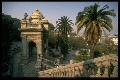
Chile offers everything to its visitors--from adventure tourism to arts and literature, to geology, to gastronomy to sociology--the possibilities are endless!
Ā
GEOGRAPHY
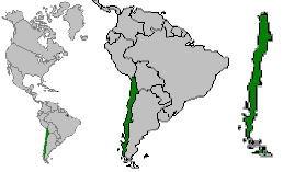
Chile is a ribbon of land extending from 18 degrees south to 56 degrees south, and is bordered by the Andes Mountains in the east and the Pacific in the west. It is precisely these barriers that make Chile seem like an island. It is 4329 kilometers long and never more than 180 kilometers wide, and only slightly larger than the area of Texas. Chile has a range of climates not matched by many other countries, from the desert and tropics in the north to the sub-Antarctic in the south. There are 2085 volcanoes in Chile, 55 of which are active, and earth tremors are common.
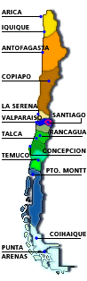
The far north of Chile is called the Great North, and the largest cities include Arica, Iquique, and Antofagasta. It is here that the Atacama Desert is located, which is said to be the driest area on earth. Some meteorological stations have never reported precipitation. It is in this northern desert area that the great mines of Chile are found.
The area just south is called the Little North, where irrigation has aided farming. Tropical fruits like the papaya and chirimoya can be grown. La Serena, an important city of this area, is said to have the clearest skies and perfect astronomical conditions; in fact, several international observatories are located here.
The central section of Chile includes a huge valley and the lakes regions. This is fertile agricultural land, and towards the south, the mountain scenery is renowned. Santiago, the capital, is located within this central valley, where 40% of the people in Chile are concentrated. The peaks of the Andes mountains are about 100 kilometers east of the city. The highest is Aconcagua at 6964 m., but many others are over 6000 m. To the west of the city is the coastal range which contributes to the major problem of smog that is often trapped between these two mountain ranges. Santiago enjoys a Mediterranean climate, with rain in the autumn and winter, but long dry spells in the summer. It is the 5th largest city in South America with a population of 6 million, and over 50% of the country's manufacturing is located here. Santiago was founded in 1541 by Pedro Valdivia and suffered major earthquakes in 1647 and again in 1730.
The lakes region, where most of the 55 active volcanoes are located, is made up of 12 great lakes and various smaller ones that contribute to the beauty of a large number of natural parks. The major cities besides Santiago include Valparaiso, Concepcion, and Valdivia.
Where the lakes region ends, the country breaks into a 1000 island archipelago, including Grand Chiloe Island. This region is made up of channels, rivers, fjords, and glaciers, interspersed with forested hillsides that reach right to the water's edge. Some islands here report 157 inches of rain annually. Settlements are smaller and more interspersed here, but larger ones include Puerto Montt, Coyhaique and Punta Arena. The farthest south is referred to as the Tierre el Fuego. Chile also owns a triangle section of Antarctica equal to 1,200,000 square kilometers, and 2 insular possessions: Easter Island, with its great stylized statues and Polynesian culture, and Juan Fernandez Island, where the marooned Scotsman Alexander Selkirk's experiences inspired the novel Robinson Crusoe