Let's Get Serious
copyright © 1995 | 
|
copyright © 1995 |
|
Filing a claim
Where can you go looking? There are lots of places in the Miner’s Guide, and you may be perfectly happy going to them. If you find a good looking deposit on your own, think about filing a claim. Claims can be filed on public land except: National Parks, military land, state owned land, Indian reservations, reservoirs, permanent lake beds, city owned land, private land, state monuments and some parts of national forests. That seems like an all-inclusive list, but it still leaves a lot of places you can file.
There are ‘locatable’ minerals, such as gold, silver, etc. and non-locatable minerals like sand, gravel, and building stone. Obviously, we’re interested in the locatable type.
First you have to ‘locate’ a claim. Dig out a topographical map of the area where you want to file. These maps are laid out in grids. You’re probably tried to find an unknown town on a road map, and found it listed in square ‘A3’, say. Topographical maps use a similar system.
Imagine a line running North and South and another running East and West. These are called meridians. The divisions North and South are called Townships, and the ones running East and West are called Ranges. So, the square just Northeast of the point where the meridians intersect is Township 1 North, Range 1 East. These maps also show contours, roads, who owns the various parcels of land, and many other details.
Let’s suppose you’ve found a nice pocket of gold, or a place where there is a good concentration of the yellow stuff. Call up the local office of the BLM, and ask for whatever information they have on how to file a claim. I’ve heard miner’s cuss the BLM, but I was treated very well, and they gave me lots of information on filing a claim.
There are four types of claims; lode claims, placer claims, mill sites, and tunnel sites. Mineral deposits are either lode claims or placer claims. A lode claim can be 600 feet by 1500 feet, with the deposit located in the middle, running the long dimension. On a lode claim, you have to erect a monument or marker at the discovery point, at each corner of the claim, and at the ends of the centerline. This type of survey is called ‘Metes and bounds’. The BLM pamphlet has a nice drawing and also tells what to build the markers out of, although states may have their own rules on this.

Typical lode claim
Each state has its own laws about mining claims, and how they have to be staked and filed. Call your state capitol and get the information on how to make sure it’s done right.
Placer claims are located by a survey method called legal subdivision, such as the Northeast 1/4 section 2, township 10 South, Range 21 East, Mount Diablo Meridian. The maximum size is 20 acres per locator (that’s you), so if there is a group of three people (this is called an association), you can claim up to 60 acres. Associations can be as big as 160 acres for 8 or more people (except Alaska, 40 acres). Corporations can claim up to 20 acres per claim.
Placer claims
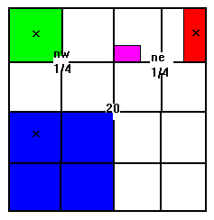
The map shows a hypothetical section which we'll call Section 20 of Township 10 South, Range 21 East of Mount Diablo Meridian. Section 20 is divided into quarters called nw, ne, sw, and se (north-west, north-east, etc.). Each quarter has four parts. Clear so far? If you forgot what township and range are, go back up the page.
The blue area is a 160 acre claim with 8 locators (people), in the sw quarter of Section 20, Township 10 South, Range 21 East of Mount Diablo Meridian. This is abbreviated SW 1/4, sec 20, T10S, R21E, MDM.
The green area shows a 40 acre placer claim with 2 locators (two partners, 20 acres per partner). It's description is NW 1/4, NW 1/4, SEC 20, T10S, R21E, MDM. That's the Northwest quarter of the Northwest quarter of Section 20, Township 10 South, Range 21 East, Mount Diablo Meridian.
The red area has one locator at E 1/2, NE 1/4, NE 1/4, SEC 20, T10S, R21E, MDM.
The little pink area is a 5 acre mill site at S 1/2, SW 1/4, NW 1/4, NNE 1/4, SEC 20, T10S, R21E, MDM.
I understand the description if I read the explanation and go over it a few times. Next week, it'll be Greek again.
Mill sites are places for putting a mill for processing the ore, and are located on non-mineral land. Tunnel sites are (surprise!) places where you want to put a tunnel.
All these claims need to be recorded with the BLM state office (In Alaska, the BLM office in Fairbanks) and the county clerk in the county where the claim is filed. If the claim is on Forest Service land, you’ll need to file a notice of intent and a plan of operation with the Ranger District Office.
Then there are the fees:
New filings, $135 ($10 service charge, $25 location fee, and $100 maintenance fee.)
Amendment/Transfer of Ownership, $5 per claim/site
Affidavit of Annual Assessment work, $5 per claim/site
Notice of Intent to hold, $5 per claim/site
Petition for Deferment of assessment work, $25 per petition
Mineral Patent application, $250 first claim
Filing for each additional claim/site in one patent application, $50 per each additional claim/site.
On top of this, you must pay $100 maintenance fee or small miners waiver certificate... each year, before August 31, in advance for the upcoming year. If you file the maintenance fee, you have to include claim names, BLM serial numbers and any address changes. If you qualify for the waiver, you must have an interest in 10 or less claims, have performed assessment work on the claims in the previous year, sign the form and include all owners addresses and file Assessment work for claims or Notice of Intent to Hold along with $5 per site with BLM before December 30.
Sound complicated? It did to me. Is it worth all the bother? Well, maybe. Consider this; if your claim is approved, you have "possessory right to develop and extract the minerals." In effect, you own all the locatable minerals. You can use as much of the surface as necessary for mining and milling, you can have access across federally managed land to get to the site, you can use as much of the timber on the claim as necessary for mining, and you can erect fences and gates to protect operations and equipment. You can’t use the land for anything except mining, however.
A mining claim is considered real property, and can be bought, sold, transferred, leased, rented, willed or inherited.
I think that knowing what you have to do up front would make it sound a lot less complicated.
Maybe you’ve heard of a "Patented Mining Claim." That’s one that the Federal government has passed title to the claimant (that’s you), thus making it private land. You would have exclusive title to the locatable minerals. In most cases, you would own the surface and all other resources. Mineral patents can be issued for lode and placer claims and mill sites, but not for tunnel sites. There’s a moritorium on patent applications which may expire at the end of fiscal year 1995. Read all about it in the BLM pamphlet.
Once the claim has been filed and recorded, you have to file a notice or plan of operations before "conducting any surface-disturbing activities." Most states also have mining and reclamation requirements, so be sure and check with BLM and state agencies to see who you need to notify. If the claim is on Forest Service land, you need to file a plan of operations with the Forest Service. Yes, it’s a lot of paper work, but if you do your homework you’ll know what to expect and what’s expected of you.
Think you might need a lawyer to make sure it’s all done right? A mining engineer to tell you if your find is worth developing? A geologist to tell you where to look next? Maybe, maybe not. But if you don’t file a claim, it’s all up for grabs by whoever else finds it. You made the find of a lifetime, and you’re telling me you’re going to risk letting it get away? Get serious!