
Arastradero Preserve
Part 1
![]()
Arastradero Preserve
Part 2
![]()
Arastradero Preserve
Part 3
![]()
Arastradero Preserve Virtual Reality Tour
![]()
Arastradero Preserve Stewardship Project

Directions
Park
Info
Map
![]()
SF Bay
Rec. &
Travel
Part 2 - Acorn and Meadowlark Trails
![]()
|
Bay Area Parks |
Bay Area Hiking |
County Parks |
Feedback |
Guided Photo Tour Continued:
This tour continues from the end of the Corte Madera Trail near the Arastradero Preserve boundary at Foothills Park. The mileage readings are a continuation of the tour in Part 1:(Click on the thumbnails for a larger picture. Hit the Back
button on
your browser to return.)
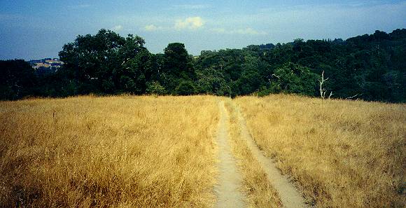
 Coming back along the trail, at 2.98
miles, you reach the start of the
upper Acorn Trail. Take this trail uphill.
Coming back along the trail, at 2.98
miles, you reach the start of the
upper Acorn Trail. Take this trail uphill.
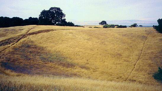
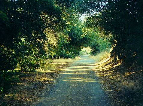
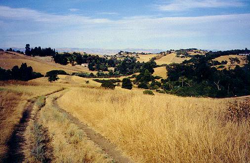
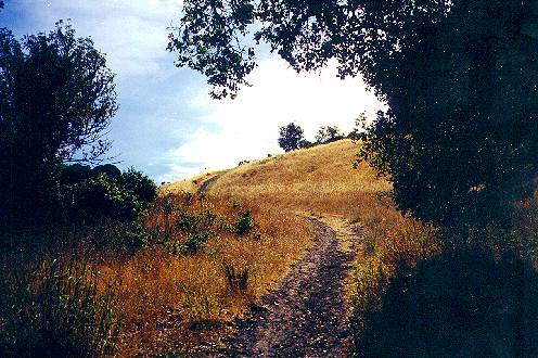 The first part runs through an oak
forest,
then climbs steeply through
open grasslands.
The first part runs through an oak
forest,
then climbs steeply through
open grasslands.
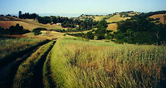
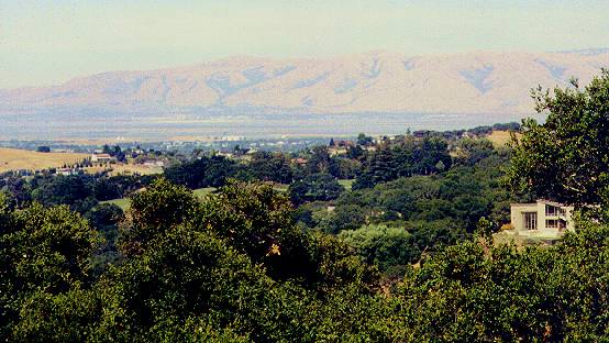
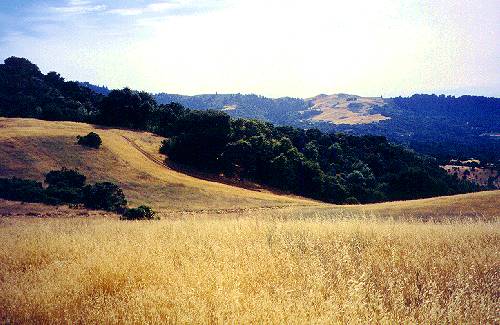
 As you ascend the hill, more of the
surrounding hills come into view. You
can see the houses on the hills on the east side of the park.
As you ascend the hill, more of the
surrounding hills come into view. You
can see the houses on the hills on the east side of the park.
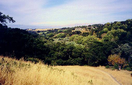
 Looking to the southeast, you can see the
Arastradero Creek watershed and
the hills of Foothills Park.
Looking to the southeast, you can see the
Arastradero Creek watershed and
the hills of Foothills Park.
 At 3.08 miles, the trail forks as it runs
on both sides of an old oak tree
near the top of the hill. The trails rejoin past the oak tree. On the
hill
are oak plantings. Black plastic on the ground marks a restoration
project.
The plastic is used to heat up the ground in an effort to control the
non-native
invasive teasels.
At 3.08 miles, the trail forks as it runs
on both sides of an old oak tree
near the top of the hill. The trails rejoin past the oak tree. On the
hill
are oak plantings. Black plastic on the ground marks a restoration
project.
The plastic is used to heat up the ground in an effort to control the
non-native
invasive teasels.
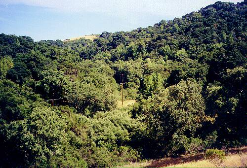
 At this altitude, you can see over the
nearby hills and catch views of
the Bay and Bayshore.
At this altitude, you can see over the
nearby hills and catch views of
the Bay and Bayshore.
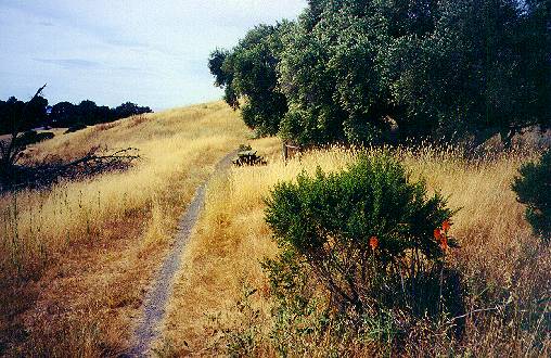
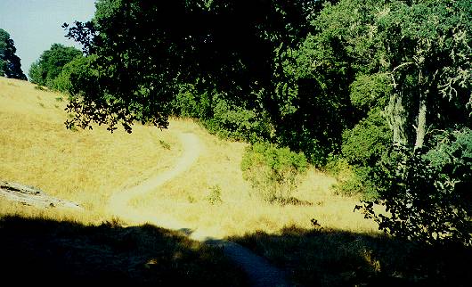
 At 3.16 miles, you reach a trail
junction.
To the left, the Acorn Trail
is a narrow path lined with tall grass and (ouch!) prickly yellow
starthistles.
On the right, the trail leads along the hill to the Meadowlark Trail.
Take
the Acorn Trail to the left.
At 3.16 miles, you reach a trail
junction.
To the left, the Acorn Trail
is a narrow path lined with tall grass and (ouch!) prickly yellow
starthistles.
On the right, the trail leads along the hill to the Meadowlark Trail.
Take
the Acorn Trail to the left.
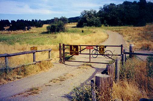
At 3.32 miles, you reach another T-junction. To the right, you can see a wide gravel service road, the Meadowlark Trail. Take a side trip to the right and go down this gravel road to the right. In this area were several buildings. There was a house to the left of the Meadowlark Trail, now marked only by trees surrounding a clearing. Farther down the trail and to the left was a barn. These buildings were disassembled and the wood recycled.
 At 3.47 miles, the Meadowlark Trail
reaches the junction of the Acorn Trail,
which runs along the hill to the right and connects back to the
T-junction
seen at 3.16 miles. The road continues downhill. However, turn around
and
backtrack along the gravel road.
At 3.47 miles, the Meadowlark Trail
reaches the junction of the Acorn Trail,
which runs along the hill to the right and connects back to the
T-junction
seen at 3.16 miles. The road continues downhill. However, turn around
and
backtrack along the gravel road.
 At 3.49 miles, a trail leads off to the
right. Along it is a picnic table
and a rack for tying up horses. Take this side trail.
At 3.49 miles, a trail leads off to the
right. Along it is a picnic table
and a rack for tying up horses. Take this side trail.
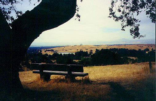 It runs uphill and ends at the top of a
hill at 3.58 miles at a bench under
a lone oak tree. A sign says "Aladdin's View." The view from this point
is one of the best in the preserve. A good portion of the Bay Area is
visible.You
can see the skyscrapers of San Francisco to the north and the
buildings
of downtown San Jose to the south. Closer in, you can see downtown Palo
Alto, and the Stanford Hills. Here are some views from the hill:
It runs uphill and ends at the top of a
hill at 3.58 miles at a bench under
a lone oak tree. A sign says "Aladdin's View." The view from this point
is one of the best in the preserve. A good portion of the Bay Area is
visible.You
can see the skyscrapers of San Francisco to the north and the
buildings
of downtown San Jose to the south. Closer in, you can see downtown Palo
Alto, and the Stanford Hills. Here are some views from the hill:
 |
 |
 |
The trail dead ends here, so after taking in the view, head back to the gravel service road, which you reach at 3.68 miles. Head back to the Acorn Trail junction, which you reach at 3.78 miles. Take the trail back to the left.

 After 3.81
miles, you reach the Acorn Trail T-junction again. Continue
on to take the loop to the west. It climbs up to the park boundary at
3.90
miles, then turns right, paralleling the boundary fence. At 3.98 miles,
it reaches another T-junction. The path to the left goes uphill into
the
woods, but it crosses into private property, so don't take it.
After 3.81
miles, you reach the Acorn Trail T-junction again. Continue
on to take the loop to the west. It climbs up to the park boundary at
3.90
miles, then turns right, paralleling the boundary fence. At 3.98 miles,
it reaches another T-junction. The path to the left goes uphill into
the
woods, but it crosses into private property, so don't take it.
 From here the trails and hills to the
north can be seen.
From here the trails and hills to the
north can be seen.
 Turn right. The trail drops down steeply,
then goes up again. At 4.05 miles,
it reaches a junction. To the right is a short path to the gravel
service
road. Take the path to the left.
Turn right. The trail drops down steeply,
then goes up again. At 4.05 miles,
it reaches a junction. To the right is a short path to the gravel
service
road. Take the path to the left.
 At 4.09 miles, it comes to a flat open
area with paths through it and around
it. Take the trail around it to the right. It climbs slightly, drops
downhill,
then begins to climb uphill.
At 4.09 miles, it comes to a flat open
area with paths through it and around
it. Take the trail around it to the right. It climbs slightly, drops
downhill,
then begins to climb uphill.
 This is a view from the hill, looking
back
down the trail to the hills
west of the park.
This is a view from the hill, looking
back
down the trail to the hills
west of the park.
 From the hill, the Meadowlark Trail can
be
seen on the right. At 4.26 miles,
you reach the crest of the hill. The view to the north shows houses in
the foothills of the Santa Cruz Mountains.
From the hill, the Meadowlark Trail can
be
seen on the right. At 4.26 miles,
you reach the crest of the hill. The view to the north shows houses in
the foothills of the Santa Cruz Mountains.
 At 4.30 miles, you reach a crossroads.
Straight ahead, the trail drops
down into a steep-sided bowl, obviously a favorite spot for bikes. You
can drop into the bowl and have fun riding up and down its sides. There
is a path on the far side of the bowl. Otherwise, turn right. At 4.32
miles,
under a big oak tree, you reach a trail junction. A trail leads uphill
to the right. A trail sign points to the left. Take the trail to the
left.
From here, you can see the Stanford Hills ahead. The trail runs along
the
north edge of the bowl and rejoins the trail on the west edge of the
bowl
at 4.35 miles.
At 4.30 miles, you reach a crossroads.
Straight ahead, the trail drops
down into a steep-sided bowl, obviously a favorite spot for bikes. You
can drop into the bowl and have fun riding up and down its sides. There
is a path on the far side of the bowl. Otherwise, turn right. At 4.32
miles,
under a big oak tree, you reach a trail junction. A trail leads uphill
to the right. A trail sign points to the left. Take the trail to the
left.
From here, you can see the Stanford Hills ahead. The trail runs along
the
north edge of the bowl and rejoins the trail on the west edge of the
bowl
at 4.35 miles.
 It turns to the right and heads downhill
to join the gravel service road.
Follow the service road to the left.
It turns to the right and heads downhill
to join the gravel service road.
Follow the service road to the left.
 At 4.56 miles, it reaches a trail
junction
at a large oak tree. A bench
provides a place to rest. The gravel service road exits the preserve at
Gate C at John Marthens Lane, which leads to Arastradero Road near
Alpine
Road. The trail to the right is the lower Acorn Trail. Take it.
At 4.56 miles, it reaches a trail
junction
at a large oak tree. A bench
provides a place to rest. The gravel service road exits the preserve at
Gate C at John Marthens Lane, which leads to Arastradero Road near
Alpine
Road. The trail to the right is the lower Acorn Trail. Take it.
 It becomes a
double-track dirt trail. It
runs across a wide-open field.
It becomes a
double-track dirt trail. It
runs across a wide-open field.
 It then drops downhill into a gully at
4.77 miles. A small creek runs to
the right through here, marked by oaks and coyote bushes.
It then drops downhill into a gully at
4.77 miles. A small creek runs to
the right through here, marked by oaks and coyote bushes.
 The trail goes up and over a small hill,
where it meets the junction of
the Perimeter Trail, which branches off to the left. Bicycles are not
allowed
on the narrow Perimeter Trail. Continue to the right.
The trail goes up and over a small hill,
where it meets the junction of
the Perimeter Trail, which branches off to the left. Bicycles are not
allowed
on the narrow Perimeter Trail. Continue to the right.
 The trail drops down to meet a wide
gravel
service road at 4.82 miles.
To the right, it becomes a paved road just past a bridge over the
creek.
Do not take this paved road, because it is just a dead end service road
to a water tank. Past the bridge, the dirt Acorn Trail continues on,
following
the far side of the creek. However, for this trip, turn left and follow
the gravel service road. At 4.94 miles, it crosses the creek. A dirt
footpath
goes up to the left to provide access to the Perimeter Trail.
The trail drops down to meet a wide
gravel
service road at 4.82 miles.
To the right, it becomes a paved road just past a bridge over the
creek.
Do not take this paved road, because it is just a dead end service road
to a water tank. Past the bridge, the dirt Acorn Trail continues on,
following
the far side of the creek. However, for this trip, turn left and follow
the gravel service road. At 4.94 miles, it crosses the creek. A dirt
footpath
goes up to the left to provide access to the Perimeter Trail.
 This is a shady route. Even though the
creek is likely to be dry, it has
a lot of vegetation growing along it.
This is a shady route. Even though the
creek is likely to be dry, it has
a lot of vegetation growing along it.
 At 5.09 miles, the road turns right and
goes uphill. At the corner, a foothpath
leads through the bushes to the Perimeter Trail. The service road now
parallels
Arastradero Road, which runs just above it to the left.
At 5.09 miles, the road turns right and
goes uphill. At the corner, a foothpath
leads through the bushes to the Perimeter Trail. The service road now
parallels
Arastradero Road, which runs just above it to the left.
 At 5.20 miles, it reaches Gate B on
Arastradero Road. Note that there is
no parking near this gate.
At 5.20 miles, it reaches Gate B on
Arastradero Road. Note that there is
no parking near this gate.
 At the gate, the Perimeter Trail (no
bicycles) follows along the perimeter
fence of the reserve next to Arastradero Road.
At the gate, the Perimeter Trail (no
bicycles) follows along the perimeter
fence of the reserve next to Arastradero Road.
 Follow
the service road to the right. It runs around a field to left that
may be covered with teasels. At 5.31 miles, a dirt trail goes up and
over
a hill to the left. The main trail continues on to the right, then
passes
through an area of broad, wide-open rolling meadows.
Follow
the service road to the right. It runs around a field to left that
may be covered with teasels. At 5.31 miles, a dirt trail goes up and
over
a hill to the left. The main trail continues on to the right, then
passes
through an area of broad, wide-open rolling meadows.
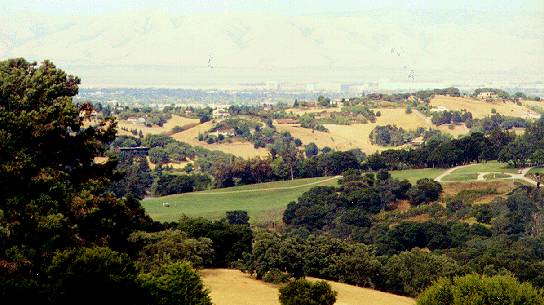
 Ahead,
the golf course can be seen on the upper hills.
Ahead,
the golf course can be seen on the upper hills.
At 5.39 miles, the service road reaches the junction with the Meadowlark Trail. The service road continues on to the south end of Arastradero Lake, where it meets the Corte Madera Trail (see the 0.87 mile point in Part 1).
 The Meadowlark Trail runs up the hills to the right to where it meets
the
junction of the gravel service road and the Acorn Trail, seen at 3.47
miles.
The Meadowlark Trail runs up the hills to the right to where it meets
the
junction of the gravel service road and the Acorn Trail, seen at 3.47
miles.
 Take the Meadowlark Trail to the left.
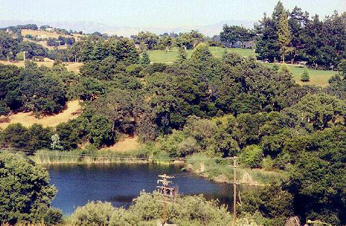 It is a dirt double-track that runs along the side of hill. Below the
trail
on the right, you can see Arastradero Lake, with the golf course on the
hills behind it.
It is a dirt double-track that runs along the side of hill. Below the
trail
on the right, you can see Arastradero Lake, with the golf course on the
hills behind it.
 At 5.57 miles, the trail drops down. You can see the hills of the
preserve
east of Arastradero Road. The trail curves to the right. You can see
Arastradero
Road and the stables up the road to the left. At 5.82 miles, you reach
the junction of the Perimeter Trail, which comes from the left. An
unmarked
dirt trail continues on straight ahead.
At 5.57 miles, the trail drops down. You can see the hills of the
preserve
east of Arastradero Road. The trail curves to the right. You can see
Arastradero
Road and the stables up the road to the left. At 5.82 miles, you reach
the junction of the Perimeter Trail, which comes from the left. An
unmarked
dirt trail continues on straight ahead.
 The Meadowlark Trail makes a sharp right
turn and drops quickly down the
hill. At 5.90 miles, it reaches the Corte Madera Trail. An unmarked
dirt
trail runs along the north side of Aratstradero Creek. Turn left at the
Corte Madera Trail and follow it back to the preserve entrance. Cross
Arastradero
Road and head back to the parking lot, which you reach at 6.15 miles.
The Meadowlark Trail makes a sharp right
turn and drops quickly down the
hill. At 5.90 miles, it reaches the Corte Madera Trail. An unmarked
dirt
trail runs along the north side of Aratstradero Creek. Turn left at the
Corte Madera Trail and follow it back to the preserve entrance. Cross
Arastradero
Road and head back to the parking lot, which you reach at 6.15 miles.
For more preserve trails, go to Part 3.
![]()
Created 7/8/01, updated 9/27/06 by Ronald Horii