
The Climb to Kaiser
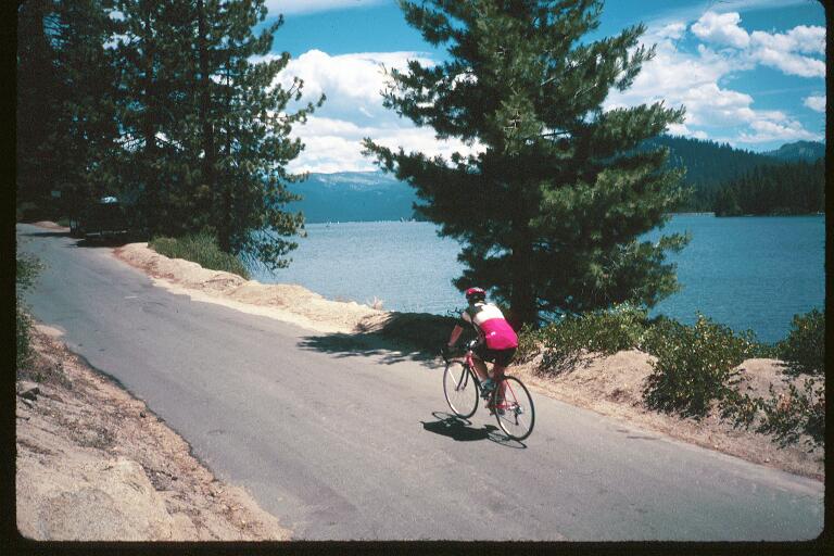

Turning on to Huntington Lake Road you're immediately confronted with yet another hill. However this one, although steep (about 9%), isn't too long. About a mile or so, tops. In fact, you can just about see the top already.
See that perfectly symetrical pine tree sitting off by itself, silhouetted against the sky? That's "Anny's Tree" (an unofficial name), and it stands on the right of the road at the summit of this "little rise".
The downhill at the end of this climb is a fast one, but if you haven't driven the course the day before, watch your speed. It's twisty and there very well could be sand in the turns. There have been a few riders that have gone over the edge.
It goes down for a while, then climbs again before finally dropping down and around the powerhouse and into the tiny town of Big Creek (Elev. 4,995). At the end of this quaint little cliffside town is the "Big Creek rest stop".
This is the smallest of the C2K's rest stops. In fact, it's not really even really a rest stop, but most people call it one. It's got water, a few snacks and porta-potty. The reason for it's simplicity is no one wants to load themselves down here.
See that hill off to the right? That's the Infamous Big Creek Grade (blare of trumpets...duh, duh, duuhhh!)
Big Creek starts off at it's average gradient of nearly 10%. Partway up it flattens out, but just as you start to think "That wasn't too bad..." It starts climbing again. And this time it keeps climbing, rarely less than 10%.
This entire climb used to be nicely shaded, until a fire in 1994 swept through here. But the fire didn't do anywhere near as much damage as the men who came after. Many of the trees were actually starting to recover when they came and cut them all down. So for the first half of this hill, you're in the sun.
The road makes a sharp 180º turn to the right and climbs even steeper as it wraps around the hillside. Another 180º turn, this time towards the left and you approach it's "maximum gradient section".
You're now climbing a mile long grade of 16%.
Here is where I would pass (sitting and singing...) most of those who thought their "featherweight wonderbikes" could climb. I've made quite a reputation for myself on this hill. But my fame, I fear, may be short lived, as more and more cyclists are discovering they can put triple cranksets on their bikes too.
This section lasts for about a mile. Shortly after you pass the sign reading "Entering Huntington Lake Recreation Area" and it mellows out.
Relatively speaking, of course.
Another 180º left turn, then a right. And just as you're beginning to wonder if this hill will ever end, it quite suddenly does. Maybe it's partly due to oxygen deprivation, you're at 7,000 feet, but it just seems to happen so fast...
And in front of you is a picture postcard of the High Sierras. Deep blue sky, a crystal blue lake, people fishing, tall pines, firs and sailboats... Almost makes you forget the climb.
Well, at least it makes it seem a little more worth the effort...
The road winds around Huntington Lake through dense forest for a while. But it doesn't follow the shoreline forever, so there are a few hills in the way.
The lunch stop used to be at Bear Cove Picnic area, but recently they've moved it to Lower Billy Creek Campground. Probably due to the campground's closer proximity to the top of the hill. Hand your machine over to one of the Kaiser Krew and go get some lunch. (A lakeside lunch complete with valet parking! How many rides offer that? :-3) )
I like to take a (very) quick dip in the lake to wash off the salt (sweat). If you care to do so, be warned, it's cold, and you're hot and tired. Don't stay in for more than a moment or you'll cramp.
The FCC stops the clock for you while you have Lunch, so there's no reason to rush through this one. I like to stay for about 20-30 minutes, which is long enough for me to dry off and fill up for the last climb to the top.
Tell one of the "valets" which bike is yours, tip him (or her) with a warm thanks, and head on your way. The road rolls a little for a couple of miles before you turn onto Kaiser Pass road. This road comes in two parts.
The first part (Hwy 168) was originally planned to go all the way over the Sierras into the Mammoth Lakes region. Thankfully, the Ansel Adams Wilderness Area put a stop to that. Imagine the traffic if it hadn't!
They did succeed in rebuilding the bottom half of this road though. So this part makes for a great downhill on the way back. (You'll see what it used to be like later on...) Since you will be coming back down this thing, make a note on the road condition going up.
Just because it was intended as a highway, don't think it isn't steep. The "easy half" of this climb is still about a 7% average grade. And it's not as well shaded as the others either. there are some great views though, so as you plug up this one, you might want to divert your attention from the road, from time to time.
Eventually the road flattens out, Actually going slightly downhill for awhile. Then it seems to dead end into the face of the mountain. That's where the highay department's plans came to their bitter end. To get to Kaiser Pass, you have to continue on the original road.
That's it. the really steep narrow one climbing off to the right...
It looks like someone poured asphalt over a fire road. Which is probably not too far from the truth. it was originally built in the very early 1900's for the construction of Florence Lake. We don't go that far though.
The average gradient of Kaiser Pass Road is almost the same as Big Creek Grade. However, since the first half isn't as steep, the second half is relentless. Up to 15% in some spots, just before the top. None long enough to qualify as a listed maximum, though.
The fir trees will start to thin out as you near the summit, dissapearing almost completely after you pass between a couple of Bristlecone pines. In 75 miles, you've passed through five climate zones. Equal to a trip from San Diego to Alaska!
People will be cheering you on for the last part of the climb. One last straight (and of course steep) stretch, and you're there. Stay here a while too. I usually don't leave till at least 1:30-2:00. That way, by the time I reach Shaver Lake, Most of the traffic will be gone.
Who want's to do a great downhill like that stuck behind a Yuckabago? Besides, It'll give the valley below a chance to cool off a little.

This page hosted by 
Get your own Free Home
Page