|
Date: |
Sunday 20th August 2006 |
|
Location: |
Lincolnshire Wolds |
|
Leader: |
John Aram & Helen Gamble |
|
Author: |
Barbara Burns |
Don’s plea for support for the outing to the Linconshire Wolds bore ample fruit, as a grand total of 29 people assembled on the track leading to the quarry at Welton-le-Wold.
The trip was organised by Cliff Bartlett and our leaders for the day were John Aram, Lincolnshire Wildlife Trust’s Welton Reserve Manager and OU tutor, who described the geological aspects of the sites we visited, and Helen Gamble, of the Linconshire Wolds Countryside Service, who explained the significance of the area in terms of the flora and fauna to be found there. She also explained the work being done to safeguard and enhance the various habitats as well as encouraging visitors to the often overlooked Area of Outstanding Natural Beauty with numerous leaflets for walks. They were ably assisted by archaeologist Jo Hambly, of Heritage Lincolnshire, who is currently conducting detailed studies of the quarry in conjunction with Royal Holloway College, London. John is proud of the fact that he was instrumental in inspiring Jo’s interest in geology – he’s now working very hard on Helen, with considerable success!
 |
|
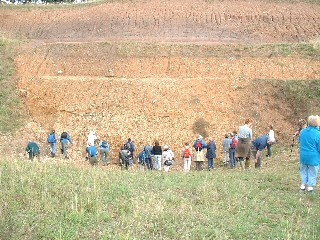
John Aram sets the scene at Welton (Photo Don Cameron) |
Welton-le-Wold is a disused gravel working with an ‘eastern’ and ‘western’ pit on either side of the road, which have not been worked for many years. The western section is on privately owned land which has recently been entered into the Countryside Stewardship Scheme. It was not possible to visit this section, due to the release of pheasants in preparation for the forthcoming shooting season! However the eastern section has been purchased by the Lincolnshire Wildlife Trust, which manages the site as a geological reserve, and the quarry is now a nationally important Site of Special Scientific Interest (SSSI) as well as a Regionally Important Geological and Geomorphological Site (or RIGS for short). Work has been funded to clear the quarry face in order to expose the stratigraphy in both sections, and to allow public access to the exposures in the Wildlife Trust Reserve.
 |
 |
|
The party examines the sequence, Welton Gravels at base, covered in turn by Welton Till, some made ground – the slightly dark band below the second bench top – and then the Marsh Till (Photo Cliff Bartlett) |
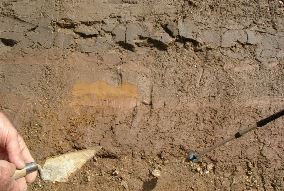
Fine, silty material which may represent glacial lake infill (Photo Don Cameron)
|
The quarry is noted for a series of Quaternary (Pleistocene) glacial deposits, and for the discovery of (derived) flint tools and fossils from an interglacial period. The underlying ‘solid’ chalk is overlain firstly by the Welton Sands and Gravels (which contained the finds), then by three distinct layers of till - the Welton Till, the Calcethorpe Till and the Marsh Till. However, the Calcethorpe Till is not visible in the eastern (Reserve) section, and the Marsh Till appears not to be present at all in the western section. The blue-grey Welton and brown Calcethorpe tills contain predominantly local clast material, chiefly chalk and flint, and are believed to represent deposits from either the Anglian glaciation or from ice surges between the Anglian and Devensian glacials. The red-brown Marsh Till, on the other hand, has been identified by its clast content – of which 90% is of non-Lincolnshire origin – as being similar to tills found at sites much further north. It is believed to represent the Last Glacial Maximum of the Devensian ice-sheet in Lincolnshire and the group found it fascinating to be standing where the edge of the glacier would once have been! However, Jo was keen to emphasise that any age dates for strata or artifacts given in publications should be treated with caution as they might only represent small amounts of data, and be made with old techniques. The geology of the site is complex, even including possible evidence of a glacial lake or inland sea (John’s ‘varves’) and John encouraged lively debate concerning the relationships of the various strata to one another. The advent of new geological techniques means the debate is still ongoing amongst the experts, so we were in good company!
After a short drive to Scamblesby, where staff at the sleepy Green Man pub eventually coped with 29 hungry geology enthusiasts descending on them for lunch, we made our way to the Red Hill Nature Reserve. Here Helen provided us with some interesting facts on the work being done in the area to preserve the rare undisturbed grassland, with its associated flora and fauna. We then made our way to an exposure of Red Chalk – another RIGS. This rock formation occurs only in Norfolk, Lincolnshire and Yorkshire and is characterized by a pinkish-white upper layer of white chalk, with the distinctive Red Chalk layer underneath, which in turn lies on top of a layer of brown Carstone sandstone, creating a ‘Neapolitan ice-cream’ effect. It is thought the colour comes from iron-rich muds washing off land raised up by salt domes in the North Sea, and becoming incorporated into the chalk forming on the sea bed. The chalk is quite rich in fossils (mainly ‘lamp shell’ brachiopods and belemnites) and the group had great fun examining the loose rocks at the base of the exposure, looking for good examples of these, while John was again on hand to explain the site’s geology and to field our questions.
 |
 |
|
A slightly overgrown exposure of Red Chalk gave rise to a scree which the party worked over for various fossils at the base. (Photo Don Cameron)
|
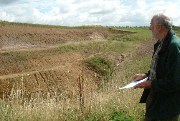
John pointed out that the quarrymen had refilled most of the pit, but that the final faces had been left almost untouched apart from a bench below the Marsh Till. As you can see from the recent erosion, the faces need to be cleaned every so often to make sure that the section stays visible (Photo Don Cameron) |
Cliff finally drew the visit to a close with a heartfelt vote of thanks to John and Helen for sharing their knowledge of, and enthusiasm for, the area with us – thanks which we were all happy to endorse. It had been an absorbing day, with plenty of questions for us to take away and mull over at our leisure, together with an impressive array of interesting leaflets and handouts. The thanks of the group are due to all the organisers, who put so much time and effort into making the day a success – and to the weather gods for ensuring we stayed dry!