|
Date: |
Saturday 5th November 2005 |
|
Location: |
Bedfordshire and Buckinghamshire |
|
Leader: |
Dr Jill Eyres |
|
Author: |
Naomi Griffiths |
Ivinghoe Beacon and Incombe Hole.
We assembled bright and early at Ivinghoe Beacon car park, where we met our leader Dr Jill Eyers (well known for her infectious enthusiasm and wide-ranging knowledge). Jill explained that the morning would be devoted to investigating the landscape, geomorphology and impact of man upon the area and that we would be visiting Ivinghoe Beacon to investigate how man has used the Beacon followed by a short walk to Incombe Hole to look at how the land was sculpted by fluvial processes that operated at the end of the last ice age.
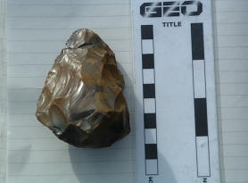
Left: Neolithic Flint handaxe. Photo © Naomi Griffiths.
Before setting off on our geological / archaeological explorations, Jill showed us some of the interesting pieces of archaeology she has collected from the area which included the following:-
- Neolithic flint handaxe fashioned out of brown flint. This fantastic artefact was passed around the group for each of us to hold and it was amazing the feel the balance and weight of the tool in the hand.
- Bronze Age pottery – rough-textured, dark red / brown in colour with pale inclusions to stop the pots shattering when they were fired. Jill explained that the pots were not thrown but moulded by hand.
- Iron Age pottery – again dark red / brown in colour but of a much finer texture.
 Left:
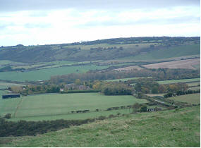
Chiltern Hills from Ivinghoe Beacon, Photo © Naomi
Griffiths.
Left:
Chiltern Hills from Ivinghoe Beacon, Photo © Naomi
Griffiths.
After marvelling at the archaeology, we set off from the car park for our first location - Ivinghoe Beacon. Ivinghoe Beacon is a hill fort but Jill explained that not all forts were located on hills (e.g. Gerrards Cross) and not all forts were defensive (some served as animal corrals while others served as ceremonial places or workshops/farms). About halfway up the hill we stopped and looked at the remains of the ditches and bank that formed the outer defensive wall of the hill fort. The ditches are now fairly shallow but originally they would have been around 4m deep and would have formed an integral part of a box rampart palisade.
At the top of Ivinghoe Beacon we were rewarded with fabulous views of the scalloped scarp slopes of the Chilterns and the flat vale at the base of the hills. At the Trig Point there is a circular barrow/mound that has not been excavated but is thought to be an early Bronze Age burial site. Magnetometer surveys have been carried out revealing a central burial area probably for a chief with satellite burial areas arranged in a circle around it. Geophysical surveys have also revealed what is believed to be a Neolithic mortuary chamber at the summit of the Beacon but there is no surface evidence for this site and it also remains unexcavated.
From the Trig Point we wandered eastwards to look at platform sites that are believed to be part of a sparse settlement that lay outside the defensive ditches. Cooking pots and animal bones have been found at this site and there was obviously a small population living here at one time. Near the eastern entrance to the fort there is a feature believed to be a midden.
The Chiltern Hills visible from Ivinghoe Beacon form a sinuous, scalloped chalk escarpment composed of Middle and Upper Chalk. The flat vale at the foot of the hills was formed by erosion at the end of the Tertiary / beginning of the Quaternary.
The villages situated along the base of the Chiltern Hills have been sites of habitation since the Neolithic and the reason for this is because they lie on the spring line where water percolating through the chalk exits at the base of the escarpment. The field boundaries visible in the vale also reveal an ancient pattern of land use. The modern boundaries that we see were mainly constructed during the Enclosures but Jill explained that by using the ‘T’ rule much larger and far more ancient ditched boundaries of Neolithic Age may be picked out among the modern fields.
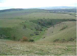
From Ivinghoe Beacon we walked the short distance to the very impressive Incombe Hole, a a large, steep-sided, sinuous ‘V’- shaped river valley cut into the chalk. At the termination of the Ice Age the area was a tundra environment with underlying permafrost. As the glaciers retreated, melt-water scoured large ‘V’- shaped river channels on the surface of the land because the melt-water was not able to percolate through the normally porous chalk since the pore spaces were filled with permafrost ice. Today, the bottom of the river valley is flat due to sediment infill that has taken place during the Holocene and the walls of the valley are stepped due to freeze-melting cycles that have caused solifluction of the overlying soils.
After a very interesting morning we retreated from the high ground to the pub to thaw ourselves out and prepare for the geological delights of Munday’s Hill Quarry.
Incombe Hole. Photo © Naomi Griffiths