|
Date: |
Sunday 21st May 2006 |
|
Location: |
The Roaches, Staffordshire |
|
Leader: |
Gerry Shaw |
|
Author: |
Cliff Bartlett |
North Staffordshire's Geology
The northeast of the county is characterised by the White Peak; an area of Carboniferous limestone and fossil reef structures as the sea became shallower, sands and grits were deposited on top of the limestone. These remain in parts, within the South West Peak and are characterised by the dramatic landforms seen at the Roaches and Ramshaw Rocks. The limestones and gritstones were followed by The Coal Measures. The shales and sandstones that underlie the rolling landscape around Stoke-on-Trent were deposited by large river deltas at the edge of a warm tropical sea, the swamps and deltas swamps supported dense tropical forests, the remains of which now form the coal seams that have long been mined in the area.
The group met in the driest part of the day, but everyone was prepared for what was to come, waterproofs leggings, plastic bags for maps and handouts. The Roaches is the name given to a sandstone/grit exposure that is very popular with climbers due to the variety of routes on its escarpment, with walkers for its easy access to the ridge and geologists for the fine easily available exposures. We walked up the gentle escarpment of the Five Clouds sandstone on the flattish ground between it and the Roaches Grit escarpment there we saw boulders that had been rounded during the Devensian Glaciation, this was the most recent glacial period starting around 73,000BP and ending 10,000BP, it was during the early Devensian that ice spread down into the Cheshire Plain from the northwest. We also passed an old gamekeepers cottage now converted into a climbing hut, surrounded by rock falls, I found have not felt that safe sleeping there!
There are a series of faults crossing the syncline
the most major of which has isolated Hen Cloud, which displayed fine dipping
bedding, whilst we could still see that far! We climbed up another of these
faults through the Roaches Grit (contains more than 25% feldspar) escarpment and
onto the ridge path which on a fine day gives outstanding views, enough said
about that. From the top of the ridge we could see across the syncline to the
other side, known as Ramshaw Rocks, in the valley bottom the change in ground
cover was a good indication of the changing bedding with mudstones (from
experience very wet ground) and a thin layer of Chatsworth Sandstone overlying
yet more mudstones and some thin coal seams which were worked in the past and
still appear to be being worked today.


There are some very fine examples of cross bedding on the side of the path which were perfectly exposed with the water running down them, note Gerry has found the only shelter to explain them to us!!!
As we continued along the ridge to Roaches end we
saw many interesting and weird wind eroded blocks also several erratics along
with evidence of the frost shattering of huge chunks of the Roaches grit
possibly resulting from the Devensian Glaciation, we stopped for a wet lunch
near Roaches End. There part of the group returned to there cars leaving the
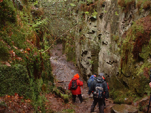
magnificent seven to continue along through some woods to Ludds Church, this
rocky cleft is the result of a landslip and there are some wonderful examples of
plant life in its micro climate, a steep set of steps lead down into the dark
depths, but on a sunny day it is just as nice.
of the frost shattering of huge chunks of the Roaches grit
possibly resulting from the Devensian Glaciation, we stopped for a wet lunch
near Roaches End. There part of the group returned to there cars leaving the
magnificent seven to continue along through some woods to Ludds Church, this
rocky cleft is the result of a landslip and there are some wonderful examples of
plant life in its micro climate, a steep set of steps lead down into the dark
depths, but on a sunny day it is just as nice.
We returned by the upper path and there appears to be a series of small faults in the dips on the ridge characterized by a different dip on each side and these may have been the source of addition water that lead to the landslips that are characteristics in the inside of the syncline in this area.
It was wet and we were all glad to get back to the cars but it was a very enjoyable day, for those of you who have not visited the area I would recommend it and the following link gives details of a good day out in fine weather.
http://www.walkingenglishman.com/peakdistrict03.htm
Thanks Gerry but could you book some dry weather next time please.