(Resolution 800 x 600)
Territorial Extension:

Departament: 1,951 Kms²

Principal Town: 120 Kms²
Population: 500,000

Altitude: 2,334m SNM

Climate: Cool in the High Lands, warm and damp in the Pacific Coast.

Clothes: For a cold climate in the principal town, summer clothes in the coast.

Languages: Spanish, Quiche and Mam


¿How to Go?:

The Panamerican Highway (CA-1) witch crosses the High Lands or

the International (CA-2), parallel to the Pacific Coast.


Kms From Quetzaltenango to:

Guatemala 206 Kms by (CA-1)

234 Kms by (CA-2)

Huehuetenango 90 Kms

Totonicapan 30 Kms


Borders:

Tapachula: 150 Kms

La Mesilla: 160 Kms

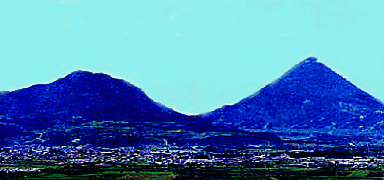
Situated at the Southwest of the Country, extended for the cold High Lands to the warm Pacific Coast, the departament has a variety of Landscapes, numerous volcanos, hot waters springs, valleys, mountains, rivers; it's possible to harverst nummerous products shuch as coffee, wheat, fruits and vegetables, whitout forgetting, the sheep and cow breeding.
For these qualities, Quetzaltenango is a privileged place to visit.
The city of Quetzaltenango
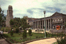
Departament principal town. Situated on an extended plain and surrounded by hills and volcanos, the city of Quetzaltenango conserves the Maya-Quiche's old traditions and the colonial past, while mantaining the dynamism of modern life.
The Mam authority, called Kulahá, reached its most important expansion. Later Quiches's Lords conquered the area and founded Xelajú previously situated at the base of the volcano Santa Maria.
Then, it was transfered to the north, and the Nahuas who went whit the Spaniards gave it the name of Quetzaltenango ("Quetzal"= the bird Quetzal; "tenango"= place of.
The center of the magistrate's authority during the hispanic period and during certain time the capital of the so-called "Sixth State of the Central American Confederation ". The town conserves traces of the colonial period in its streets and avenues. The classic, neoclassic and italian rennaisance styles are evident in the buildings and the houses wich have been built during the past century and the beggining of the 20th, whit volcanic stones by "Quetzaltecos" artful massons. Some examples of architectural styles:
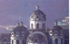
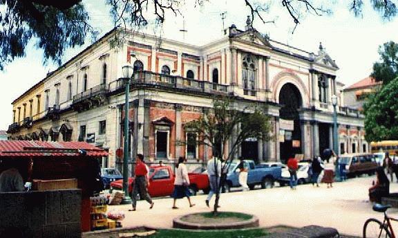
"Espiritu Santo" cathedral :
Consist of two strucures.
The "Espiritu Santo" parish's ancient facade (1535/1896)
and to the back the "Diócesis de los Altos " (1899).
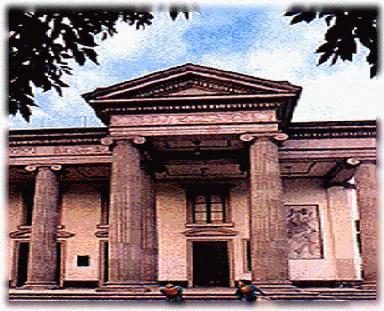
The Municipal Theatre:
is a very important
Neoclassical work.
The "Central America " park:
Situated in the centre of the town is also centre of cultural activities
and amusements.
The "Enrique" Passage
Near the central park.
"Gobernacion " one block from the central park.
You must visit the "Cerro del Baúl ". There you'll have a beatifull view of Quetzaltenango's valley, day or night (accesible by foot, car or taxi).
Quetzaltenango has important cultural activities. There, you'll find the Occidental Cultural Centre "La Casa de la Cultura de Occidente", and "Alliance Française de Quetzalteango", numerous activities are scheduled all year.
The first Sunday of each month, the "Quetzaltecos" install the artisans' Market in the central park where handcrafts from Quetzaltenago and surronding villages are displayed. In september, the annual fair and festival is offered from the 12th to the 18th.
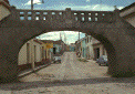
The "Quetzaltecos " villages of Quiche and Mam origins, have small places with impressive colonial style churches where the tourist will see the regional handcrafts displayed on market days.
Salcajá: 9 kms. from Quetzaltenango. Market day: Tuesday. local festival the 25th of august. Here was constructed the church of San Jacinto, the first of the religious constructions of the region and a beatiful example of colonial architecure. Also famous for its hand-woven "jaspe " materials and unique alcoholic beverages known as "caldo de fruta" " and "rompopo" .
San Juan Ostuncalco 12 kms. from Quetzaltenango. Situated in a valley of the mountainous region, it is the comercial centre for the Mam-speaking villages which burder the departament. Here you may acquire musicals instruments, wicker furniture as well as lovely hand woven materials.
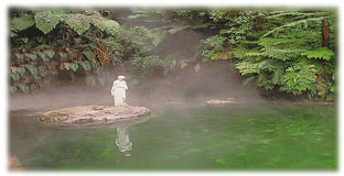
Almolonga 5 km from Quetzaltenango. Market on wednesday and saturday. Annual festival the 26th-29th of june. Known for its variety of vegetables wich are cultivated on the smell farms which surround the village. You will also enjoy thermal springs such as "Las aguas amargas" and "El rosario" .
Cantel 10 km from Quetzaltenango. Visit the interesting cooperative for handmade blown glass.
Olintepeque: 7 Km from Quetzaltenango. The place where according to legend, the famous Maya-Quiche prince Tecún Uman died in battle against Pedro de Alvarado in 1524.
Zunil a 9 km fromQuetzaltenango. Monday is market day. Located
on the Samala river and on the main highway leading own the coast, Zunil's
people wear attractive clothes made by hand using traditional techniques
featuring intrincate designs and bright colors. This picturesque town is
the center for the worship of "Maximon" or "San Simon"
a life-sized mannequin endowed whith occult power: Just 8 Kms. from
tonw on the slopes of the inactive Zunil volcano you'll find the beautiful
"Las Georginas" thermal springs, equipped whit restaurant and
bungalows.

Volcán Santa Maria 12,256 feet & Santiaguito. The summit of the Santa Maria Volcano lies at the endo of the steep 3-4 hours climb from the village of Llanos del Pinal (locates 6Kms. above Quetzaltenango). You'll best enjoy the truly awesome view during the clearer weather of the early morning hours. The whole coastal plain lies at your feet, along whit the cities of Quetzaltenago and Tapachula, Mexico. You can look down into the very active "Santiaguito" crater which erupts at least once every hour. You can still enjoy the view minus the ragged hike by driving to the top of the adjacent "Siete Orejas" Volcano. 10,384 feet above the sea level).
San Andres Xecul 7 kms from Quetzaltenango, in the direction of the "Cuatro Caminos" highway junction, whit a colonial-style whose facade is both color full and picturesque.
La laguna de Chicabal 3 hours by foot from the village of San Martin Chileverde (14 Kms from Quetzaltenango). At this very picturesque lagoon, the sorceres of the whole region meet on the 3th of may.
To the High Country
Totonicapan Near Quetzaltenango, you have to visit the principal town Totonicapan (in the departament of the same name). Known for its hand woven textiles and his potteries.
San Francisco El Alto Friday, Site of the Central America's largest market. V
Momostenango: Wednesday & Sunday: Market. This curious "Riscos de Oro", rock formation produced by erosion.
San Cristobal Totonicapan Church and Convent of the XVII th.
Hacia la Costa
El Palmar Town destroyed by Santiaguito Volcano. Lagoons and tropical vegetations.
Retalhuleu 62 Kms.,Cuyotenango y Coatepeque 120 Kms from Quetzaltenango. Swiming pool and tropical climate. .
Pacific Beach
Champerico, Tilapa, Las Delicias, Tulate.