
Copenhagen - C¶te d'Azur - Lyon 1994
 In 1994 I went on my first bicycle tour from Copenhagen in Denmark to the C¶te d'Azur in
southern France. This tour of 2500 km went trough western Germany to Alsace and Le
Vosges in France, the Jura mountains, the Alps in Switzerland and France, Provence and the C¶te
d'Azur and finally along the Rh¶ne river to Lyon. I used 27 days for this ride, and I slept on various
campgrounds along the route. The campgrounds are usually quite cheap when you only have a small
tent, but I experienced prices ranging from free(!) to as much as 18 DM on a popular site in
mid-germany. I didn't cook any food myself, mainly because I didn't want to carry so much equipment,
In 1994 I went on my first bicycle tour from Copenhagen in Denmark to the C¶te d'Azur in
southern France. This tour of 2500 km went trough western Germany to Alsace and Le
Vosges in France, the Jura mountains, the Alps in Switzerland and France, Provence and the C¶te
d'Azur and finally along the Rh¶ne river to Lyon. I used 27 days for this ride, and I slept on various
campgrounds along the route. The campgrounds are usually quite cheap when you only have a small
tent, but I experienced prices ranging from free(!) to as much as 18 DM on a popular site in
mid-germany. I didn't cook any food myself, mainly because I didn't want to carry so much equipment,
 but also because of the price. You get a LOT of bread and cheese in France for almost nothing! I
mostly used the supermarkets, but also gaz stations and smaller stores. And now don't forget to visit
the ice-cream shelfs in the IntermarchÚ stores - imagine resting in the shade with a huge amount of
Carte d'Or pistacie after having biked 120 km in bright sunshine?
Actually I took off from Denmark together with my friend Thomas , but after 8 days or so, his bike began
to fall apart (yes, it did!) and though we made several attempts to repair it, the problem always returned.
So Thomas went back to Denmark, and waited of course the obligatoric 5 hours at Hamburg Hbf... As we
had planned the tour for quite a long time, I decided to go on, and so I continued alone.
but also because of the price. You get a LOT of bread and cheese in France for almost nothing! I
mostly used the supermarkets, but also gaz stations and smaller stores. And now don't forget to visit
the ice-cream shelfs in the IntermarchÚ stores - imagine resting in the shade with a huge amount of
Carte d'Or pistacie after having biked 120 km in bright sunshine?
Actually I took off from Denmark together with my friend Thomas , but after 8 days or so, his bike began
to fall apart (yes, it did!) and though we made several attempts to repair it, the problem always returned.
So Thomas went back to Denmark, and waited of course the obligatoric 5 hours at Hamburg Hbf... As we
had planned the tour for quite a long time, I decided to go on, and so I continued alone.
But anyway, this is it: The first part
together with Thomas went past L³beck to Lauenburg/L³neburg where we made our first wrong turn.
We biked some 7-8 kilometers before the road got really bad, and we realized that we had entered the
newly opened DDR. But as a sort of a compensation we met a happy and friendly man, who offered us a
Kinder Milchschnitte. Quite funny, but not a great pleasure to eat! We continued to Uelzen and Celle,
and here the first problems with Thomas' bike arrived. We now had to camp in the forest outside Celle,
 which turned out to be a memoriable experience... We nearly got runned over by a german ICE train
passing us at 300 km/h, then we made our way trough the bushes with our bikes, to finally get some
sleep on a not so comfortable spot under some trees, but apart from that it was a night like any other...!
The next day we arrived in Celle, which is a beutiful old town, and even well supplied with japanese tourists!
Don't miss it, it's sure worth the sight. As we went south of Hannover the first small mountains began to rise
near Hildesheim. We stayed for 2 days on a campground outside a little town named Wallensen, and here
Thomas decided to go home. So happyly we found a railway-track on the map, but of course it turned out to be
a steam train that was only runned on special occasions a few times a year. So we continued to the next
town where there was a "real" train. So long, goodbye... - Now I headed straight for the growing hills, and
which turned out to be a memoriable experience... We nearly got runned over by a german ICE train
passing us at 300 km/h, then we made our way trough the bushes with our bikes, to finally get some
sleep on a not so comfortable spot under some trees, but apart from that it was a night like any other...!
The next day we arrived in Celle, which is a beutiful old town, and even well supplied with japanese tourists!
Don't miss it, it's sure worth the sight. As we went south of Hannover the first small mountains began to rise
near Hildesheim. We stayed for 2 days on a campground outside a little town named Wallensen, and here
Thomas decided to go home. So happyly we found a railway-track on the map, but of course it turned out to be
a steam train that was only runned on special occasions a few times a year. So we continued to the next
town where there was a "real" train. So long, goodbye... - Now I headed straight for the growing hills, and
 passed trough some very nice mountain areas covered with trees and a lot of small lakes and creeks, and I
crossed the Rhine at Wiesbaden and Mainz. Here I went into a gaz station to buy some refreshments and I
payed the lady in the store with 200 DM, but as I got outside I realized that she had only given me change for
50 DM. So I went back in and complained, but she had to wait until closing time to count the money and to see
if I was right. As I of course didn't want to spend half a day waiting for the store to close, we agreed on her
sending me a check if she would find that I was right. Sure, I said to myself... - But one week or so after my
return to Denmark, I recieved a check from her with the remainig 150 DM...
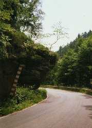
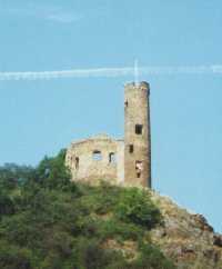
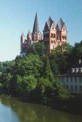
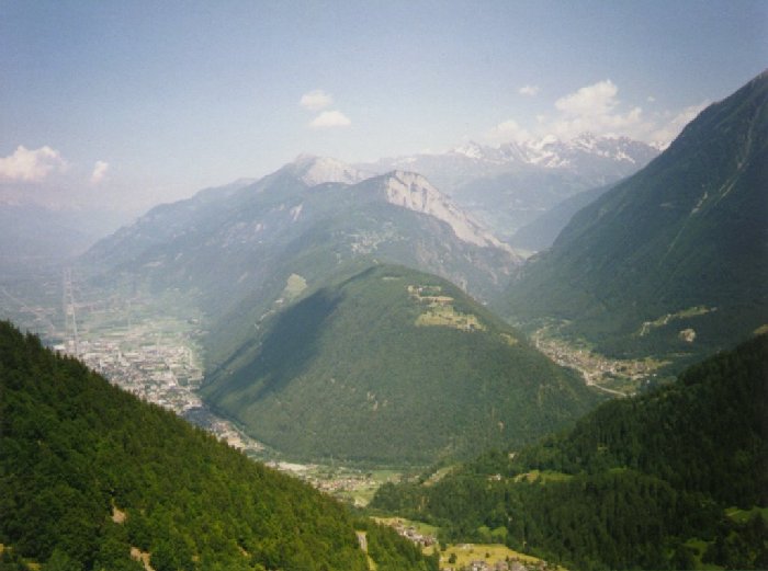
Now I was approaching Les Vosges, the small mountain range
that actually begins around Kaiserslautern and continues
southwards into France. This area is very beautiful, and has a lot
of old ruins and castles, always located on the top of some high
cliffs. As I entered France I noticed how every village, no matter
how small, had at least one fountain with delicious cold water - a
passed trough some very nice mountain areas covered with trees and a lot of small lakes and creeks, and I
crossed the Rhine at Wiesbaden and Mainz. Here I went into a gaz station to buy some refreshments and I
payed the lady in the store with 200 DM, but as I got outside I realized that she had only given me change for
50 DM. So I went back in and complained, but she had to wait until closing time to count the money and to see
if I was right. As I of course didn't want to spend half a day waiting for the store to close, we agreed on her
sending me a check if she would find that I was right. Sure, I said to myself... - But one week or so after my
return to Denmark, I recieved a check from her with the remainig 150 DM...
Now I was approaching Les Vosges, the small mountain range
that actually begins around Kaiserslautern and continues
southwards into France. This area is very beautiful, and has a lot
of old ruins and castles, always located on the top of some high
cliffs. As I entered France I noticed how every village, no matter
how small, had at least one fountain with delicious cold water - a
 gift from above for a cyclist... I continued trough these heavily
forested mountains, and around La Petite-Pierre (imagine a more
French-like name?!) it got rather cloudy and it soon turned into a
thunderstorm. As I was driving some 500 m above sea level I was
actually surrounded by thick clouds in every direction, the
loudest thunder I've ever heard was rolling between the
mountains and I could see the lightning belov me in the valleys.
I of course didn't want to seek cover under a tree and so I continued as fast as possible to
get further down and find a campground for the night. The bad weather continued for one
more day, though at least not with thunder. I made an 18 km climb in heavy rain to the Col
du Donon (1009 m), which was the highest pass so far, and though I thought of it as
rather hard, it should within in a week turn out to be one of the easiest on the tour... The
next day offered a clear sky, and I passed the little town GÚrardmer and now the
mountains slowly disappeared. Now I crossed the open land between Les Vosges and the
Jura mountains, and I went trough the villages of Lure, Villersexel and Baume-les-Dames.
Here I passed the Doubs river, which flows trough Besanþon and into the Sa¶ne. The
next wall of mountains appeared at Pontarlier, where I arrived late in the afternoon. It was
rather dark already, and so I continued 18 kilometers and found a campground in Les
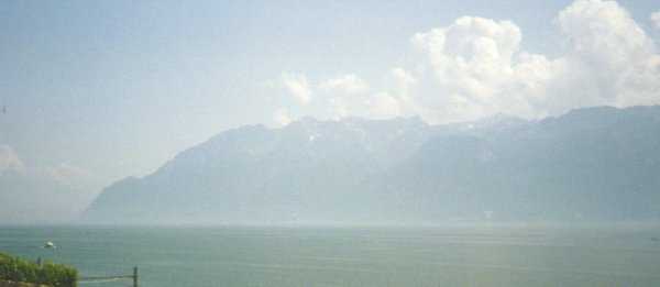
H¶pitaux-Neuf. Early the next day I passed the Swiss border, and began a beautiful
descent towards the flat area between Lac de NeuchÔtel and Lac LÚman. Actually I didn't
plan to visit Switzerland, and so I didn't carry any Swiss francs, but the stores accepted
French francs, though complaining a lot. So advised by a friendly man in a gas station I
later went into a small hotel to change some money. Now I had arrived in Lausanne and
here there were some great views of the Alps rising 2 kilometers above the water on the
other side of the huge lake...
gift from above for a cyclist... I continued trough these heavily
forested mountains, and around La Petite-Pierre (imagine a more
French-like name?!) it got rather cloudy and it soon turned into a
thunderstorm. As I was driving some 500 m above sea level I was
actually surrounded by thick clouds in every direction, the
loudest thunder I've ever heard was rolling between the
mountains and I could see the lightning belov me in the valleys.
I of course didn't want to seek cover under a tree and so I continued as fast as possible to
get further down and find a campground for the night. The bad weather continued for one
more day, though at least not with thunder. I made an 18 km climb in heavy rain to the Col
du Donon (1009 m), which was the highest pass so far, and though I thought of it as
rather hard, it should within in a week turn out to be one of the easiest on the tour... The
next day offered a clear sky, and I passed the little town GÚrardmer and now the
mountains slowly disappeared. Now I crossed the open land between Les Vosges and the
Jura mountains, and I went trough the villages of Lure, Villersexel and Baume-les-Dames.
Here I passed the Doubs river, which flows trough Besanþon and into the Sa¶ne. The
next wall of mountains appeared at Pontarlier, where I arrived late in the afternoon. It was
rather dark already, and so I continued 18 kilometers and found a campground in Les
H¶pitaux-Neuf. Early the next day I passed the Swiss border, and began a beautiful
descent towards the flat area between Lac de NeuchÔtel and Lac LÚman. Actually I didn't
plan to visit Switzerland, and so I didn't carry any Swiss francs, but the stores accepted
French francs, though complaining a lot. So advised by a friendly man in a gas station I
later went into a small hotel to change some money. Now I had arrived in Lausanne and
here there were some great views of the Alps rising 2 kilometers above the water on the
other side of the huge lake...
 I followed the shore of Lac LÚman all the way
to Montreux, and continued into the valley of
the Rh¶ne river to Martigny. Here on the left
hand there's some high and sharp peaks named
Les Diablerets, and on the right hand lies Les
Dent du Midi and the famous skiing areas
around Morzine/Avoriaz. Now I really was in
the Alps and I began the ascent towards Col
de la Forclaz, which I still think is one of the
most dramatic ports to the Alps. The pass
is very hard to climb from the east, but
around 10-11 km it offers some spectacular
views of Martigny, 1 km below...!
On a clear day you can see all of the great Rh¶ne-valley, with Les Diablerets
and Jungfrau on the left and the white peaks around Matterhorn on the right. At the summit
the road turns into a trilling descent with great views towards Massif de Mont Blanc
but also with some rough turns! Just as the descent seems to go on forever, the
road suddently crosses the French border and begins to rise towards Col des Montets at
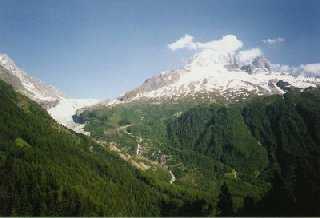
1461m. But from here the road again hurls down into the Chamonix valley, and here I camped
in Les Houches. That evening I decided to eat dinner on a restaurant at the foot of the
Mont Blanc, and I wonder if anybody noticed me in my colorful cycling outfit as I enjoyed
my dinner and stared at the mountain, while listening to Corona's "The rhythm of the night" in
the background (quite an experience...!)
The Chamonix valley is absolutely beautiful, but the road is, I guess, not
meant for cyclists. There are some unpleasant sections, with quite a lot of
traffic. As I continued westwards out of the valley, I passed some very
high, and almost vertical cliffs where the road splits up and one lane
goes on an elevated bridge for several kilometers until it reaches the bottom of
another huge valley. Here there's some great views to both Mont Blanc and
I followed the shore of Lac LÚman all the way
to Montreux, and continued into the valley of
the Rh¶ne river to Martigny. Here on the left
hand there's some high and sharp peaks named
Les Diablerets, and on the right hand lies Les
Dent du Midi and the famous skiing areas
around Morzine/Avoriaz. Now I really was in
the Alps and I began the ascent towards Col
de la Forclaz, which I still think is one of the
most dramatic ports to the Alps. The pass
is very hard to climb from the east, but
around 10-11 km it offers some spectacular
views of Martigny, 1 km below...!
On a clear day you can see all of the great Rh¶ne-valley, with Les Diablerets
and Jungfrau on the left and the white peaks around Matterhorn on the right. At the summit
the road turns into a trilling descent with great views towards Massif de Mont Blanc
but also with some rough turns! Just as the descent seems to go on forever, the
road suddently crosses the French border and begins to rise towards Col des Montets at
1461m. But from here the road again hurls down into the Chamonix valley, and here I camped
in Les Houches. That evening I decided to eat dinner on a restaurant at the foot of the
Mont Blanc, and I wonder if anybody noticed me in my colorful cycling outfit as I enjoyed
my dinner and stared at the mountain, while listening to Corona's "The rhythm of the night" in
the background (quite an experience...!)
The Chamonix valley is absolutely beautiful, but the road is, I guess, not
meant for cyclists. There are some unpleasant sections, with quite a lot of
traffic. As I continued westwards out of the valley, I passed some very
high, and almost vertical cliffs where the road splits up and one lane
goes on an elevated bridge for several kilometers until it reaches the bottom of
another huge valley. Here there's some great views to both Mont Blanc and
 several other high peaks. The next climp was from St. Gervais to MegÞve,
an easy but rather long ascent. It has its moments, but the great part of the
road is after the little village Flumes. Here I got a high speed ride trough the
dramatic Gorges de l'Arly, as the road continues downward and finally
joins the main road leading to Albertville.
Now I was following the flat road along the IsÞre river, but soon I turned
east along the Arc river and found a campground named "Camping du lac
bleu", although I never saw any lake there!
several other high peaks. The next climp was from St. Gervais to MegÞve,
an easy but rather long ascent. It has its moments, but the great part of the
road is after the little village Flumes. Here I got a high speed ride trough the
dramatic Gorges de l'Arly, as the road continues downward and finally
joins the main road leading to Albertville.
Now I was following the flat road along the IsÞre river, but soon I turned
east along the Arc river and found a campground named "Camping du lac
bleu", although I never saw any lake there!
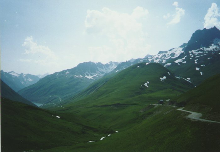
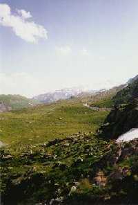 The following morning I headed
straight for Col du Glandon and Col de la Croix de Fer, two often
used passes in the Tour de France. The northern side of the Glandon
is one of the hardest climps in the French Alps, and is very hard near
the summit. This area is absolutely stunning with a deep blue lake on
the south side of the Glandon, and bright snow scattered along the
road even in July! From the summit of Croix de Fer (2067 m), the
horizon is packed with sharp peaks and smooth curved plains covered
with gray and red rocks, and the views from here are truly spectacular.
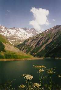
On the long descent I passed the dammed lake on the southern side of
the Glandon. It's a huge reservoir with an incredible deep blue/green color.
Around the lake there's snowcapped peaks and green plains in every
direction, and the traffic on the roads are almost non-existing even on the
brightest summerdays.
The following morning I headed
straight for Col du Glandon and Col de la Croix de Fer, two often
used passes in the Tour de France. The northern side of the Glandon
is one of the hardest climps in the French Alps, and is very hard near
the summit. This area is absolutely stunning with a deep blue lake on
the south side of the Glandon, and bright snow scattered along the
road even in July! From the summit of Croix de Fer (2067 m), the
horizon is packed with sharp peaks and smooth curved plains covered
with gray and red rocks, and the views from here are truly spectacular.
On the long descent I passed the dammed lake on the southern side of
the Glandon. It's a huge reservoir with an incredible deep blue/green color.
Around the lake there's snowcapped peaks and green plains in every
direction, and the traffic on the roads are almost non-existing even on the
brightest summerdays.
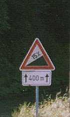
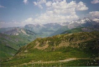
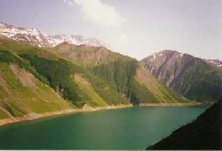
 I continued past the Montagne des Sept Laux where the road has a
descent of 10% for more than 4 km. Suddently for a short time the road
went upwards again, but it soon returned to a long descent towards
another dammed lake and then came to an end near the Veneon river.
The descending road from Glandon joins the main road leading from
I continued past the Montagne des Sept Laux where the road has a
descent of 10% for more than 4 km. Suddently for a short time the road
went upwards again, but it soon returned to a long descent towards
another dammed lake and then came to an end near the Veneon river.
The descending road from Glandon joins the main road leading from
 Grenoble to Bourg d'Oisans. This is a nice old town located at the foot
of the famous Alpe d'Huez. Here I rested in the evening, and looked
around in the narrow streets, and of course got an ice-cream...! This is
also the starting point of the ascent towards Les Deux Alpes, where
Marco Pantani founded his victory in the Tour de France 1998.
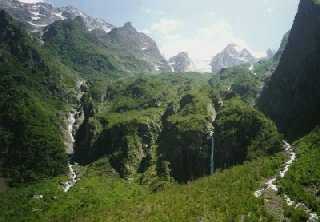
In the morning I went past the Alpe d'Huez and began the climb
towards Col du Lautaret at 2058 meters. This pass is fairly easy, and
offers some beautiful scenery, especially concerning the great Massif
des Ecrins with peaks from 3500 to over 4000 meters. The landscape
here is more rough than the north-western Alps, with wild creeks
hurling down every cliff and some more dramatic shaped peaks with
almost vertical sides. From the summit there is a quiet 7.5 km long
road leading to the famous Col du Galibier, located 588 meters
higher. But I continued heading for Brianþon and the more Provencial
part of the Alps. The road on the eastern side of the summit offered a
descent of more than 45 km (!), and after having free-wheeled for half an
hour, it was a rare pleasure to pick a small campground for the night
and still know that I would begin the next day with a yet another
thrilling descent.
Grenoble to Bourg d'Oisans. This is a nice old town located at the foot
of the famous Alpe d'Huez. Here I rested in the evening, and looked
around in the narrow streets, and of course got an ice-cream...! This is
also the starting point of the ascent towards Les Deux Alpes, where
Marco Pantani founded his victory in the Tour de France 1998.
In the morning I went past the Alpe d'Huez and began the climb
towards Col du Lautaret at 2058 meters. This pass is fairly easy, and
offers some beautiful scenery, especially concerning the great Massif
des Ecrins with peaks from 3500 to over 4000 meters. The landscape
here is more rough than the north-western Alps, with wild creeks
hurling down every cliff and some more dramatic shaped peaks with
almost vertical sides. From the summit there is a quiet 7.5 km long
road leading to the famous Col du Galibier, located 588 meters
higher. But I continued heading for Brianþon and the more Provencial
part of the Alps. The road on the eastern side of the summit offered a
descent of more than 45 km (!), and after having free-wheeled for half an
hour, it was a rare pleasure to pick a small campground for the night
and still know that I would begin the next day with a yet another
thrilling descent.
 In the city of Brianþon I encountered a sign stating that this was Le Capital
du Soleil (Capital of Sunshine!), and I sure had to admit that... In the
southern France I experienced temperatures around 43 C, but then it should
be said that the whole southern Europe had a very hot summer that year. I
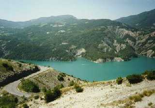
was now riding along the Durance river, passing through Digne, and I arrived
at Lac de Serre-Poncon which has a low 2 km long bridge crossing it from
Savines-le-Lac at the east side to the west side where the road continues
towards Gap. The lake is no more than 4 km across, but almost 30 km long,
and I followed the shore all the way. The last 10 km I could see the road on
the other side where I would soon be biking... This was one of the most
beautiful places on the tour, and yet the road was surprisingly quiet.
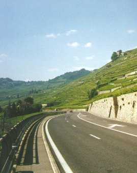
Now the mountains had changed into more flattened hills, though still with sharp
cuts and peaks here and there, and the vegetation was more bush-like, because of
the high temperatures and the strong sunlight. I was now in the upper part of
Provence, the goal of my tour! I find it hard to descripe this landscape, but I think
the pictures speak for themselves...
In the city of Brianþon I encountered a sign stating that this was Le Capital
du Soleil (Capital of Sunshine!), and I sure had to admit that... In the
southern France I experienced temperatures around 43 C, but then it should
be said that the whole southern Europe had a very hot summer that year. I
was now riding along the Durance river, passing through Digne, and I arrived
at Lac de Serre-Poncon which has a low 2 km long bridge crossing it from
Savines-le-Lac at the east side to the west side where the road continues
towards Gap. The lake is no more than 4 km across, but almost 30 km long,
and I followed the shore all the way. The last 10 km I could see the road on
the other side where I would soon be biking... This was one of the most
beautiful places on the tour, and yet the road was surprisingly quiet.
Now the mountains had changed into more flattened hills, though still with sharp
cuts and peaks here and there, and the vegetation was more bush-like, because of
the high temperatures and the strong sunlight. I was now in the upper part of
Provence, the goal of my tour! I find it hard to descripe this landscape, but I think
the pictures speak for themselves...
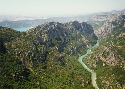
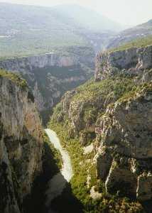 The main attraction in Provence must be the magnificent Canyon
du Verdon.
This is in fact the second largest canyon in the world!
The "main" entrance is located right at the famous Lac de Ste.
Croix, from which a quiet road passes trough a small village
named Aiguines, and crawls the vertical 450 m to the first
spectacular viewpoint, and then continues upwards to the
summit 800 m above the river. There is a road all the way along
the edge of the canyon on both sides, so it is possible to follow the
road around the enitre canyon. But remember to go
counter-clockwise or else you will position yourself at the outer
part of the road...!
The main attraction in Provence must be the magnificent Canyon
du Verdon.
This is in fact the second largest canyon in the world!
The "main" entrance is located right at the famous Lac de Ste.
Croix, from which a quiet road passes trough a small village
named Aiguines, and crawls the vertical 450 m to the first
spectacular viewpoint, and then continues upwards to the
summit 800 m above the river. There is a road all the way along
the edge of the canyon on both sides, so it is possible to follow the
road around the enitre canyon. But remember to go
counter-clockwise or else you will position yourself at the outer
part of the road...!
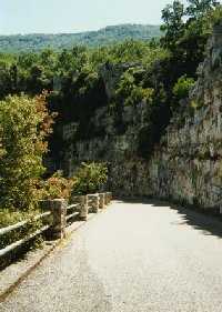
 The vertical 800 m fall to the Verdon river is
only guarded by a 50 cm high stone-built wall...! But
anyway, this place is among the most stunning I've ever seen.
The Verdon river flows through the canyon into Lac de Ste.
Croix, and contiunes until it meets the Durance river, which I
also followed around Brianþon.
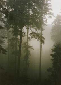
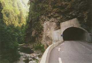
After a little turn in the vestern Provence the Durance finally enters the huge Rh¶ne near
Avignon. The road along the canyon got very
narrow in some places, and it even ended up
going in a tunnel in the cliff, like some sort of
a gallery. Not far from the tunnel I reached
Pont de l'Artuby, a very impressive bridge
crossing the entire canyon. The bridge was
white and it looked really fantastic in the
bright sunlight. I suppose one could take a
nice bungee-jump from here, as there is more
than 500 m from the bridge down to the
river...! I ended this wonderful day driving
through the jagged hills east of the canyon,
while the sun vas setting and highlighting the
faint mist that had gathered in the valleys
during the day. The next morning I had to go
through a millitary area, and according to my
map the road was closed "in periods", but I
didn't knov when that should be.
Fortunately enough the road turned out to be open
(it would have been 50 km extra if it wasn't), so I just
headed on.
The vertical 800 m fall to the Verdon river is
only guarded by a 50 cm high stone-built wall...! But
anyway, this place is among the most stunning I've ever seen.
The Verdon river flows through the canyon into Lac de Ste.
Croix, and contiunes until it meets the Durance river, which I
also followed around Brianþon.
After a little turn in the vestern Provence the Durance finally enters the huge Rh¶ne near
Avignon. The road along the canyon got very
narrow in some places, and it even ended up
going in a tunnel in the cliff, like some sort of
a gallery. Not far from the tunnel I reached
Pont de l'Artuby, a very impressive bridge
crossing the entire canyon. The bridge was
white and it looked really fantastic in the
bright sunlight. I suppose one could take a
nice bungee-jump from here, as there is more
than 500 m from the bridge down to the
river...! I ended this wonderful day driving
through the jagged hills east of the canyon,
while the sun vas setting and highlighting the
faint mist that had gathered in the valleys
during the day. The next morning I had to go
through a millitary area, and according to my
map the road was closed "in periods", but I
didn't knov when that should be.
Fortunately enough the road turned out to be open
(it would have been 50 km extra if it wasn't), so I just
headed on.
 And the following day I finally arrived at the C¶te d'Azur.
I celebrated this moment by buying a kilo of some delicious strawberrys
and eating them alltogether while resting under a pine tree. Just what
I needed! Then I turned out on the road along the riviera. The road itself is excellent but there can be
some heavy traffic, especially in the early afternoon. I camped at a huge campground near Le Lavandou
with tourists from many different countries, but mostly european. This was of course one of the more
expensive campgrounds... the following morning I continued towards HyÞres and Toulon, and from here
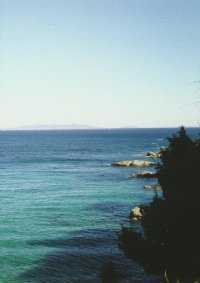
there are many fine views of the Iles d'HyÞres, a short range of islands located 20 km from the coast.
Just outside HyÞres I left the coast and began the last part of the tour up to Lyon. I went back into
the more mountainous terrain. I found a very small and quiet road connecting the two towns Barjols and Varages.
In some places it appears more like a footpath than a regular road, but it is in fact paved all the way.
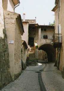
In Varages there are some beautiful sceneries and a nice tunnel through some cliffs right in the middle of the town.
And the once again I was suddently following the shore of the Durance river, now an old friend of mine...
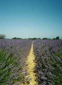
Now I was getting closer to the huge wineyards of C¶tes du Rh¶ne, and the impressive Montagne du Luberon
was clearly visible in the horizon. This mountaing is actually a small range of peaks between 600 and 1100 m,
and I followed the mountains until I reached Cavaillon, and from here I continued on the main road to Carpentras.
On the eastern side of the city there is a fantastic roman aquaduct, which looks just like it was built yesterday...!
This is a well known city from the Tour de France, where it usually is the starting or ending point of the stage
to Mount Ventoux. I didn't go across the famous mountain but instead continued into the Rh¶ne valley and crossed the
river near MontÚlimar. From here I headed straight for Lyon while enjoying the beautiful views of the river, the huge wineyards,
and a sunflower field here and there...
And the following day I finally arrived at the C¶te d'Azur.
I celebrated this moment by buying a kilo of some delicious strawberrys
and eating them alltogether while resting under a pine tree. Just what
I needed! Then I turned out on the road along the riviera. The road itself is excellent but there can be
some heavy traffic, especially in the early afternoon. I camped at a huge campground near Le Lavandou
with tourists from many different countries, but mostly european. This was of course one of the more
expensive campgrounds... the following morning I continued towards HyÞres and Toulon, and from here
there are many fine views of the Iles d'HyÞres, a short range of islands located 20 km from the coast.
Just outside HyÞres I left the coast and began the last part of the tour up to Lyon. I went back into
the more mountainous terrain. I found a very small and quiet road connecting the two towns Barjols and Varages.
In some places it appears more like a footpath than a regular road, but it is in fact paved all the way.
In Varages there are some beautiful sceneries and a nice tunnel through some cliffs right in the middle of the town.
And the once again I was suddently following the shore of the Durance river, now an old friend of mine...
Now I was getting closer to the huge wineyards of C¶tes du Rh¶ne, and the impressive Montagne du Luberon
was clearly visible in the horizon. This mountaing is actually a small range of peaks between 600 and 1100 m,
and I followed the mountains until I reached Cavaillon, and from here I continued on the main road to Carpentras.
On the eastern side of the city there is a fantastic roman aquaduct, which looks just like it was built yesterday...!
This is a well known city from the Tour de France, where it usually is the starting or ending point of the stage
to Mount Ventoux. I didn't go across the famous mountain but instead continued into the Rh¶ne valley and crossed the
river near MontÚlimar. From here I headed straight for Lyon while enjoying the beautiful views of the river, the huge wineyards,
and a sunflower field here and there...
Rolf Wahl Olsen 1998