Summary, Introduction, Methods, Analysis, Results, Discussion, References, Acknowledgements, Photos, Links
![]()
Results
CLUMP DISTRIBUTION AND CHARACTERISTICS
A total of 124 km of river and lakeside vegetation, as well as 34 km of transect, were sampled for the presence of Marona, with a bias towards areas around Boca Amigo and San Juan Grande. A total of 896 clumps, each effectively an individual plant were encountered during these surveys (Table 1). The majority were concentrated around the aforementioned communities, 399 and 368 clumps respectively.
The supervised classification analysis, which used reflectance information from 222 locations, revealed that the total area of forest with the highest likelihood of encountering Marona is 63.7 km2, or 32% of the study site (Fig. 4). In the case of the core area the extent was 9.47 km2 or 30% respectively. However, these results must be viewed with caution, as many areas indicating the presence of Marona were in fact found on inspection to be devoid of the species. It is likely that the reflectance characteristics of the species and the vegetation immediately around it, does not appear to be sufficiently unique for it to stand out against other habitat types.
The maximum number of culms per clump, >40 mm dbh, was 116 (Fig. 5). This large clump, located at UTM 381788, 8604848, which in addition had 95 dead or dying culms and only 6 juvenile culms, was in the process of flowering. The overall mean clump size was 5.82 ± 0.47 culms/clump, a figure that differed significantly between areas within the study site (Kruskal Wallis, X2 = 14.2, df = 4, P < 0.01). The mean number of juvenile culms also differed (Kruskal Wallis, X2 = 15.2, df = 4, P < 0.01). In both cases the means were highest in San Juan Grande. The mean number of dead culms per patch did not differ.

Fig. 4. False colour composite image of a supervised classification analysis showing the extent of various reflectance classes across the study area. Red = floodplain forest with high likelihood of Marona; Dark green = floodplain forest with low likelihood of Marona; Blue = water bodies and cloud shadows; White = beaches, short grass and clouds; Light green = forest of high reflectance dominated by secondary vegetation, G. weberbaueri, G. sarcocarpa or bambusoids; Brown = terra firme forest; Yellow = palm dominated swamp forest.

Fig. 5 Frequency distribution of the number of culms per clump (N = 896).
Table 1. Survey results grouped by location. Locations sharing a letter for any parameter mean did not differ significantly from one another at the 0.05 level. Statistical tests: ab = Mann-Whitney U; cd = Chi2; *** = Krukall Wallis, P < 0.001; +++ = Chi2 P < 0.001; n.s. = no significant difference. Numbers in parentheses are sample sizes, where these differ from the number of clumps.
| Location |
No. clumps |
No. culms (>40 mm dbh) |
Mean number of culms/clump |
Mean number of dead culms/clump |
Mean number juv. culms/clump |
Mean Light level/clump |
| Boca Amigo |
399 |
2 281 |
5.72 ± 0.87 a |
1.69 ± 0.69 (388) a |
0.71 ± 0.15 (319) a |
2.46 ± 0.10 (149) c |
| San Juan G. |
368 |
2 240 |
6.09 ± 0.63 b |
0.83 ± 0.16 (360) a |
0.85 ± 0.12 (362) b |
2.52 ± 0.06 (297) cd |
| Huitoto |
71 |
408 |
5.75 ± 0.86 b |
0.80 ± 0.56 (15) a |
0.57 ± 0.22 (70) a |
2.63 ± 0.13 d |
| Paña Cocha |
31 |
123 |
3.97 ± 0.94 ab |
0.78 ± 2.28 a |
0.85 ± 0.33 ab |
2.37 ± 0.22 cd |
| Malvinas |
27 |
159 |
5.89 ± 2.56 a |
1.81 ± 0.58 a |
0.55 ± 0.38 ab |
2.65 ± 0.33 cd |
| Total |
896 |
5 211 |
5.82 ± 0.48 *** |
1.27± 0.35 (821) n.s. |
0.76 ± 0.08 (809) *** |
2.52 ± 0.05 (575) +++ |
Diameter breast height for a total of 2 391 culms was successfully measured in 3 of the 5 locations: Boca Amigo, Huitoto and Paña Cocha. Figure 6 depicts the frequency distribution of culm dbh. The maximum and mean diameter for all culms was 183.6 and 79.1 ± 1.14 mm, respectively. The number of culms greater than 80 mm dbh, the level above which is regarded as economically important, was 1 033, equivalent to 43.2% of the sampled population. Mean dbh varied significantly between the three locations (Kruskall Wallis, X2 = 21.5, df = 2, P < 0.001, Table 2), and was greatest in Boca Amigo. Dbh also varied significantly between different transects within the core area (Kruskall Wallis, X2 = 371, df = 7, P < 0.0001) illustrating the diversity in age structure of clumps in this area.
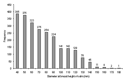
Fig. 6 Frequency distribution of the dbh of 2 391 culms.
Table 2. Mean culm dbh and 95% confidence levels for three areas. Means sharing a letter did not differ significantly from one another at the 0.05 level.
| Area |
N |
Mean dbh (mm) |
± |
| Boca Amigo |
1863 |
80.77 a |
1.35 |
| Huitoto |
407 |
72.74 b |
2.24 |
| Paña Cocha |
123 |
73.62 b |
4.24 |
ABUNDANCE AROUND BOCA AMIGO
A total of 16.71 km of transect were surveyed for Marona in the core area. Assuming a uniform detection distance of 50 m either side of the transects, the effective area sampled was 16.71 ha. This area represents 5.23% and 8.60% of the core area as a whole and the floodplain forest of interest, respectively (Table 3). A total of 399 Marona clumps were encountered during transect surveys, equating to a density of 23.88 clumps/ha. or 136.59 culms/ha. By extrapolation therefore, one might expect around 4 642 clumps in the core area as a whole, disregarding areas of river, beaches, cleared land and terra firme forest, for a total of 26 553 culms, 43% (11 418) of which could be economically important.
The plot surveys revealed that in multiple tree-fall gaps where Marona is present, the mean number of culms/ha is considerably higher than the underlying mean for the core area as a whole (Table 4). This fact coupled with the variation in abundance observed between transects implies that the distribution of Marona is highly clumped across the landscape.
Soil analyses revealed that soil colour near clumps can be broadly described as dark greyish brown (10YR 4/2), but did not vary significantly between closed canopy forest and gaps dominated by Marona. In terms of soil texture, the mean percentage of clay was significantly higher in gaps (21.14 ± 7.41%) than in adjacent closed-canopy forest (Mann Whitney, U = 11.5, P < 0.05).
Table 3. The area and percentage coverage of 3 land cover categories in the core area, and that sampled by transects.
| Land Category |
Area (km2) |
% Coverage |
| 1. Rivers + Lakes + Cleared land |
10.85 |
33.96 |
| 2. Terra firme forest |
1.66 |
5.21 |
| 3. Floodplain forest |
19.44 |
60.83 |
| Total |
31.96 |
100.00 |
| Transect sample area |
1.67 |
5.23 |
| Transect sample area (% of floodplain forest only) |
8.60 |
Table 4. The number and density of culms, >40 mm dbh, found in each of the three multiple tree-fall gaps sampled.
| Gap No. |
No. of clumps |
Plot size (ha) |
Total no. of culms found and marked |
Mean number of culms/ha. |
| 1 |
11 |
0.3 |
212 |
707 |
| 2 |
14 |
0.01 |
31 |
221 ± 217 |
| 3 |
20 |
0.01 |
24 |
120 ± 120 |
![]()
Summary, Introduction, Methods, Analysis, Results, Discussion, References, Acknowledgements, Photos, Links