Summary, Introduction, Methods, Analysis, Results, Discussion, References, Acknowledgements, Photos, Links
![]()
Methods
STUDY SITE
The study site is located 100 km from the town of Puerto Maldonado, Madre de Dios, in South-eastern Peru. It is centred on 12º35’30.1"S, 70º08’04.8"W and covers an area of 200 km2, the majority of which is floodplain forest of types A-E (Phillips 1993, Nicholson & Phillips 1994), straddling the Madre de Dios River (Fig. 1). Areas of terra firme forest (types G and H) and permanently flooded swamp forest (type A), characterised by the presence of Brazil nut (Bertholletia excelsa) and Aguaje palms (Mauritia flexuosa), respectively, were excluded from the study site as initial indications proved that these habitats are too dry or too wet to sustain Marona. The site includes land associated with the rural communities of Boca Amigo, San Juan Grande, Malvinas and Huitoto as well as the newly designated Los Amigos Conservation Concession. Mean annual temperature and precipitation are 24oC and 2 400 mm, respectively (ONERN 1972). A marked dry-season, where monthly precipitation rarely exceeds 100 mm, is evident between the months of July and September. Soils are classified as Aquults (Ultisols) or Tropepts (Inceptisols), are periodically inundated and generally poorly drained (Nicholson & Phillips 1994). The vegetation is characterised by tropical moist forest and is dominated by tree species such as Iriartea deltoidea, Attalea sp., Astrocaryum murumuru, Pseudolmedia laevis, Caryocar amygdaliforme, Polsenia armata, Dipteryx micrantha, Ficus sp., Spondias mombin, Manilkara sp. and Clarisia racemosa.
An estimated population of 1 500 people, of mestizo origin and essentially recent immigrants from the highlands of Peru, live within the study site. Most live in and around the community of San Juan Grande and are involved in small-scale alluvial gold mining, swidden agriculture, commerce and timber extraction (Valega 1999). Few if any local people traditionally use Marona as an NWFP resource.
In addition to the principle study site, a core area of 32 km2, centred on the Boca Amigo community (Fig. 1), was also identified for a more detailed analysis of population density utilising conventional line transect and quadrat techniques.
DISTRIBUTION OF CLUMPS
Census surveys across the study site were conducted over an 8-week period both by boat, along the Madre de Dios River and associated lakes, and by foot, along line transects situated within the forest (Fig. 1). Four people, including the author, were involved in these surveys. The perpendicular detection distance associated with the river/lake-based and foot-based surveys was 75 and 50 m, respectively. On encountering a clump of Marona the following data was collected: grid reference (UTM), obtained using a global positioning system (Garmin® 12XL and external antenna); the number and diameter at breast height (dbh) of culms greater than 40 mm dbh; the number of dead or dying culms; the number of juvenile culms (deemed to be recently germinated culms which had yet to set leaf); and an estimate of the level of exposure of each clump to direct sunlight in a range from 0-3, where 0 = no direct sunlight, and 3 = 100% direct sunlight. Such data was used to estimate the phenotypic and illuminatory characteristics of Marona clumps.
Remotely sensed Landsat-7 Thematic Mapper (TM) satellite imagery of the study site, obtained on the 23rd of May 2000, corresponding to 5 spectral bands (TM bands 1-5), in conjunction with GIS software, ArcInfo® and ArcView®, was used to map the distribution of clumps encountered and to determine the reflectance characteristics of pixels dominated by Marona. This, in turn, was used to estimate the likely extent of Marona-dominated forest across the study site and core area.
ABUNDANCE AROUND BOCA AMIGO
The core area of 32 km2, centred on the Boca Amigo Community (12º35’58.4"S, 70º05’12.8"W, Fig. 1), was identified for more intensive investigation after the initial analysis of distribution highlighted this area as one of the two most important population centres. The main method implemented to estimate the density of clumps was line transect surveys. Fifteen transects of varying length were distributed across the core area. Transect length depended upon time available, terrain and vegetation type, and varied from a minimum of 0.42 km to a maximum of 3.12 km. The data collected during transect surveys was identical to that mentioned above.
In addition an assessment of density in three multiple tree-falls gaps using quadrat techniques was also undertaken (Fig. 2). This habitat type was identified by the author early on in the study as having a relatively high abundance of Marona when compared with adjacent areas of closed canopy forest. In one of the gaps was sited a 55 x 55 m (0.3 ha) permanent sample plot, in which all culms greater than 40 mm dbh were counted and individually numbered with aluminium tags. Across each of the two remaining gaps, and approximately perpendicular to the long axis of each gap, two parallel series of plots, each 10 by 10 m, were sited such that plots were situated both within the gaps and in adjacent closed-canopy forest (Fig. 2). In an alternate fashion each plot was sampled and data collected on number of adult clumps with at least one culm greater than 40 mm dbh and the total number and dbh of culms greater than 40 mm dbh, each culm of which was permanently marked with an aluminium tag.
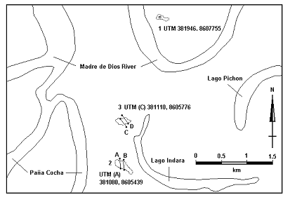
Fig. 2. Location and orientation of three multiple tree-fall gaps sampled using a 0.3 ha plot (1) and parallel transects of 100 m2 plots (2, 3).
SOIL PROPERTIES
Soil colour and soil texture (the percentage of sand, silt and clay) were assessed from soil samples taken within the quadrats used to investigate Marona density. In order to even out any localised variation in these variables, due for instance to tip-up mounds from fallen trees, a soil sample from any one quadrat was made up of five 30 cm-deep cores taken from representative areas within the quadrat. Soil colour was assessed using Munsell® Soil Colour Charts (Plate 3). Soil colour provides an indication of the mineral and organic content of soil as well as the degree of soil gleying and mottling, a process of colour change brought about by anoxic conditions. Anoxic horizons do not allow root penetration. Where such horizons are close to the surface trees may be prone to wind throw due to shallow rooting and unstable, saturated soils (Griscom pers. com.). Soil texture was assessed using a conventional soil texture kit (Plate 3). The technique is based on the use of a texture dispersing agent, which helps dissolve a soil sample into its constituent particles. The percentage of each fraction is determined from the proportion of material in solution that settles out in a given time (in this case, sand = 30 seconds, silt = 30 minutes, clay = 24 hours). Soil profiles, a means of assessing soil structure, in areas of high and low Marona density, were also obtained by excavating pits 1 m2 and 1.5 m deep.
CULM GROWTH RATE
The height of 37 recently germinated culms, from 30 individual clumps, grouped by transect, were measured in the core area between the 16th and 21st of July, 2001. Culms were marked for subsequent future identification. Height was reassessed 42-43 days later, in some cases it was necessary to fell culms to allow accurate measurement as some had grown out of reach of the observers.
CULM BIOMASS
To determine the relationship between the diameter and biomass of a culm, 30 short sections of culm of varying diameter, and from a variety of clumps, were collected. The diameter, length and average wall thickness of each section was measured using callipers to the nearest 0.1 mm. The sections were subsequently taken to Puerto Maldonado, cut-up, placed in paper bags, dried in a conventional gas-fired oven for 12 hrs at approx. 80oC, and subsequently weighed to the nearest 0.1 g on a precision balance.
VEGETATIVE PROPAGATION
Due to a lack of seeds alternative means of propagating Marona are required. Most bamboos can readily be reproduced using vegetative propagules (Farrelly 1984, Dunkelberg 1985, Cusack 1997 and Janssen 2000). Five different parts of the Marona plant, and three soil/habitat types, were tested for their effect on germination success. These five treatments consisted of: 1 rhizome, including two nodes from the basal region of a culm; 2 two-internode sections from the basal region of a culm; 3 two-internode sections from the basal region but filled with water; 4 two-internode sections from the mid region of a culm; and 5 two-internode sections from the upper branches. Three plots, each 5 x 5 m, were sited near the LARC at varying distances from the Madre de Dios River in areas known to differ in how much flooding they experience during the rainy season (Fig. 3). Plot 1 was situated in the transition zone between floodplain to terra firme forest on sloping land, had well oxidised relatively sandy soils although due to constant runoff received from the terra firme forest soil moisture levels were higher than expected. It had a closed-canopy of secondary forest species and never experienced flooding. Plot 2 was situated 30 m away and downslope from plot 1 in an open level area of abandoned pasture dominated by grasses. The soil had more clay in it than plot 1, would experience short periods of flooding during the rainy season, but was overall relatively low in moisture due to its exposed nature. Plot 3 was situated in a seasonally inundated habitat close to the river with a canopy dominated by pioneer species such as Gynerium sagittatum, Cecropia sp., and Croton sp. This habitat floods frequently during the rainy season, sometimes to a depth of 1.5 m, the soil is subsequently relatively anoxic, heavily gleyed, and high in silt and clay deposits. Moisture levels in this plot at the time of planting were intermediate with respect to the other two.
In each plot, five replicates of each treatment were planted horizontally, 1 m away from each other, at a depth of 15 cm, in a Latin Square formation (Fig. 3), and subsequently irrigated daily for the first 2 weeks, and thereafter every 2-3 days for the following 6 weeks. After 8 weeks, the Marona sections were unearthed and germination success was assessed by counting the total number of shoots emanating from the three nodal or axial buds. Those that did not germinate where deemed dead and exposed of. The remainder were replanted in their original location and permanently identified by red-tipped wooden stakes and numbered aluminium tags, in order to monitor plant development into the future (Plate 2).
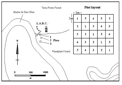
Fig. 3. Location and experimental layout of propagation plots in the vicinity of the Los Amigos Research Center (LARC). 1-5 = Latin Square layout of treatments in plots.
CULM TREATMENT AND SEASONING TECHNIQUE
Eight mature culms, each between 16-24 m long, from two large clumps (one centred on 12º35’30.7"S, 70º05’12.6"W and the other on 12º36’13.6"S, 70º05’47.9"W), were harvested and cut up into 46 sections. Between 5 and 9 replicate culm sections were subjected to each of 6 treatment and seasoning regimes. These included: 1 culm sawn and left standing in the forest on a wooden stake, off the ground, for 3 weeks, and subsequently sawn into 1.5 m sections and air-dried at the LARC for a further 3 weeks, a process known as vinegrar (Londoño pers. com., Plate 2); 2 culm felled, transported to LARC, sawn into 1.5 m sections, submerged in running water for 8 days, and subsequently air-dried for 5 weeks; 3 as in 2, except submerged in water for 24 days and air-dried for 3 weeks; 4 culm felled, transported back to LARC, sawn into 1.5 m sections, smoked in the rafters of a kitchen over an open fire for 2 weeks, and air-dried for a further 4 weeks; 5 culm felled, transported back to LARC, sawn into 1.5 m sections, treated within 24 hours with a 2% solution of Borax and Boric Acid (BBA) using a Boucherie system (Farrelly 1984, Janssen 1995, Cusack 1997), and subsequently air-dried for 3 weeks; 6 culm felled, transported back to LARC, sawn into 1.5 m sections, received no treatment and was simply air-dried for 8 weeks (Control). Culm sections were subsequently assessed for the number of hairline and structurally damaging cracks, as well as the incidence of borer and fungal attack.
To investigate weight loss on drying, three small diameter culms, approx. 60 mm dbh, were harvested, sawn into seven separate 1.5 m sections, weighed with a spring balance to the nearest 50 g and left to air-dry for 6 weeks in the LARC laboratory. During this period sections were reweighed a further 3 times.
![]()
Summary, Introduction, Methods, Analysis, Results, Discussion, References, Acknowledgements, Photos, Links