![]()
![]()
| Return to the "Put-in" (Home page) | Format of descriptions | Disclaimers |
| RIVER: | Perch River |
| LOCATION: | 6 miles W of Covington, MI; 24 miles SW from L'Anse |
| AMENITIES: | Click for Michigan Amenities (food, lodging, etc.) |
| PUT-IN: | Hwy. 28 bridge |
| TAKE-OUT: | Campgrounds on Sturgeon River |
| SHUTTLE: | Proceed 2 miles west on Hwy.28 to Pequet Lake Road, right (N) 2 miles to fork, veer right, proceed approximately 3 miles to cross the Sturgeon River, and the campgrounds will be on your left. |
| DIST: | 5.5 miles |
| TIME: | 3.0 hours |
| CLASS: | II(III) |
| CHARACTER: | Nice trout stream, with many snags, punctuated by a bit of low grade rapids. |
| GAUGE: | Visual, at put-in. If it looks floatable here, there's enough for the run. |
| SEASON: | Spring (not that you're likely to care). |
 Since this river runs parallel to the Rock River
(about 6 miles to the East), and has a similar size, we suspected it could be similarly entertaining. We were wrong. The first mile and a half is flat and filled with snags. (A bushwhack (boat-in? /drag-in?) may be possible on Sauna Creek, trading off this hassle.) The next mile contains some decent
(II-ish) action, then the river peters out for another mile and a half.
Since this river runs parallel to the Rock River
(about 6 miles to the East), and has a similar size, we suspected it could be similarly entertaining. We were wrong. The first mile and a half is flat and filled with snags. (A bushwhack (boat-in? /drag-in?) may be possible on Sauna Creek, trading off this hassle.) The next mile contains some decent
(II-ish) action, then the river peters out for another mile and a half.
|
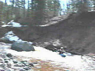 The final half mile (+/-) picks up and provides the best action (II-III)
on the run, as the Perch drops to meet the Sturgeon, on which you will
have a very short paddle on good flow (I-II) to the take-out.
The final half mile (+/-) picks up and provides the best action (II-III)
on the run, as the Perch drops to meet the Sturgeon, on which you will
have a very short paddle on good flow (I-II) to the take-out.
Note: Vidcaps (photos) from fair water level run (1993.04.23). |