

VOLKSRUST
Province/state: Mpumalanga (previously Transvaal Province/Transvaal Colony/Zuid Afrikaansche Republiek).
Additions: –
Incorporated: 2000, into Seme Local Municipality.
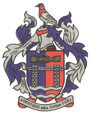
The arms may be blazoned:
Arms: Per pale azure and gules; overall a railway bridge argent composed of a deck and two stone pillars masoned sable, each pillar issuant from the upper of a pair of barrulets wavy argent in base; in chief a pair of sleeved dexter hands or, clasped in greeting.
Crest: A rock pigeon proper.
Wreath and mantling: Argent and azure.
Motto: Fortitudo mea civium fides.
About the arms:
The shield tells a story about the Third Swaziland Convention, signed in December 1894 by President Paul Kruger and the British High Commissioner, Sir Henry Loch.[1]
Neither of them was willing to negotiate on the other’s territory, so the railway bridge over the Grensspruit (border stream), marking the border between the Zuid Afrikaansche Republiek and Natal, was chosen as a neutral venue. A railway coach was placed in the middle of the bridge (today called the Convention Bridge), straddling the middle of the stream. The two statesmen could then sit at the conference table, each on his own soil.
The bridge was proclaimed a historical monument in 1954.
The wavy barrulets symbolise the stream.
The clasped hands symbolise Kruger and Loch and the agreement they reached over the future of Swaziland. That state became a protectorate under the auspices of both the ZAR and Britain. Britain became the sole protector in 1900, following the annexation of the ZAR.
The bird shown in the crest is badly drawn, and resembles either a woodpecker or some kind of grub-eater, but is in fact intended to be an African rock pigeon (Columba guinea), an allusion to the nearby hill/mountain of Majuba (“hill of doves”).
About the town:
Volksrust was established on the farms Zandfontein, Verkyk, Boschpad Drift and Llanwarne (Rooibult), which were acquired by the ZAR government for this purpose in 1888. The town was proclaimed on 27 March 1889.
The Volksraad (ZAR parliament) requested Dorothea de Jager, daughter of Dirk C Uys (“Swart Dirk”) and wife of Field-Cornet G W J de Jager, to name the town. She decided on Volksrust (“people’s rest”), probably because the burghers rested there after the Battle of Majuba (27 February 1881), which was expected to afford the Boer people a long period of restful peace.
The hill Majuba is only 15 km south of Volksrust.
On the town square, Voortrekker Square, is a monument in honour of the burghers who took part in the First Anglo-Boer War.
On the eve of the South African War (also called the Second Anglo-Boer War) the ZAR forces massed at Sandspruit, a railway halt 16 km north of Volksrust, before crossing into Natal.
The town acquired a health committee in 1893, which was replaced by a village council in 1903 and a municipality the following year.
The Drakensberg escarpment (much lower here than on either the Lesotho borders or in central Mpumalanga) forms the southern boundary of the Volksrust district, which is also the border between Mpumalanga and KwaZulu-Natal.
Following the local government elections of 2000, Volksrust became part of the Seme Local Municipality, together with Amersfoort, Perdekop and Wakkerstroom. Seme forms part of the Eastvaal District Municipality.
