
and the Pound Gap Road


| The Oldest House in the Valley | |||||||||||||||||||||||||||||||||||||||||||||||||||||||||||||||||||||||||||
|
|||||||||||||||||||||||||||||||||||||||||||||||||||||||||||||||||||||||||||
| Chapter Six: Senator May and the Pound Gap Road |
|||||||||||||||||||||||||||||||||||||||||||||||||||||||||||||||||||||||||||
|
|||||||||||||||||||||||||||||||||||||||||||||||||||||||||||||||||||||||||||
| Like most frontiersmen of his period, Samuel May was a loyal Democrat and a strong supporter of Andrew Jackson, the champion of backwoods causes on Capitol Hill. When his loyal wife Catherine bore him his fourth son on January 28th, 1829--increasing the size of his family to fourteen, all counted--Samuel named the boy after his hero, who was just beginning his first term as president. | |||||||||||||||||||||||||||||||||||||||||||||||||||||||||||||||||||||||||||
| For a larger version of this image, click here. | |||||||||||||||||||||||||||||||||||||||||||||||||||||||||||||||||||||||||||
| In thirty-two years the boy would become Colonel Andrew Jackson May, the Hero of the Battle of Ivy Mountain. No doubt it was Jackson's success in politics which inspired Samuel to throw his own hat into the ring. In 1832, riding on the coat-tails of Jackson's victory over Henry Clay, Samuel was elected State Representative for Floyd and Pike Counties, and from 1835 to 1839 he served as Floyd County's State Senator. | |||||||||||||||||||||||||||||||||||||||||||||||||||||||||||||||||||||||||||
| Jackson's politics were populist, agrarian, and anti-aristocratic. He favored a protective tariff for American farm products, and he opposed the centralization of power represented by the Bank of the United States. Like many Democrats, he believed that the Bank's tight money policy had brought on the Panic of 1819 and the Depression of 1819-1823. When a bill rechartering the national bank passed Congress in 1832, Jackson promptly vetoed it. Some historians believe that his destruction of the bank and his policy of distributing government funds among state banks set the stage for the Panic of 1837. | |||||||||||||||||||||||||||||||||||||||||||||||||||||||||||||||||||||||||||
| In the 1830s the life of a Kentucky politician was filled with hardships. Since no wagon roads existed between Prestonsburg and Frankfort, Senator May had to make the trip to the annual session on horseback. Furthermore, since his district contained no auditoriums or high school gymnasiums, he often delivered his speeches in an open field, standing on a tree stump. It is from this practice that we have derived the modern expression, "stump speech." George Caleb Bingham's painting, The County Election, painted in 1854, gives us some idea of what Samuel's political campaigns must have been like: | |||||||||||||||||||||||||||||||||||||||||||||||||||||||||||||||||||||||||||
|
|||||||||||||||||||||||||||||||||||||||||||||||||||||||||||||||||||||||||||
| For a larger view, click here. | |||||||||||||||||||||||||||||||||||||||||||||||||||||||||||||||||||||||||||
| Tress Francis, writing in 1956, tells us that old-timers in Whitesburg recalled that Samuel, during his senatorial race against Nathaniel Collins, delivered one of his speeches from a rock cliff above the banks of the Kentucky River. | |||||||||||||||||||||||||||||||||||||||||||||||||||||||||||||||||||||||||||
| Francis claims that Samuel was an excellent orator, and that his senatorial speeches were "considered fine" by all who heard them. One indication of his popularity with other politicians is the fact that the Governor, on one occasion, gave him a special gift as a reward for his service to the Commonwealth. After Samuel's death in 1851, this heirloom, a finely-wrought sword-cane, passed from his widow to R. F. Vinson of Louisa, who married the daughter of Dr. Perez S. Randall and Mahala May Randall. From Vinson, according to Francis, the cane passed to Colonel A. J. May and his son, Andrew J. May, Junior. Its present whereabouts is unknown. | |||||||||||||||||||||||||||||||||||||||||||||||||||||||||||||||||||||||||||
|
|||||||||||||||||||||||||||||||||||||||||||||||||||||||||||||||||||||||||||
| Here is the Old State Capitol in Frankfort, Kentucky, where sessions of the Kentucky State Senate were held during the 1830s. | |||||||||||||||||||||||||||||||||||||||||||||||||||||||||||||||||||||||||||
| During his term in the legislature, Senator Samuel May fought hard to bring internal improvements to Floyd County. More specifically, he fought for funds to dredge the Big Sandy and make it navigable for steamboats, and he fought for funds to improve county roads. In the 1830s the county's road system consisted of old wilderness trails passable only by shank's mare or saddle horse. To be a successful farmer, Samuel needed wagon roads, because success in farming depends on the producer's ability to ship large quantities of grain over long distances. To make them fit for wagons, roads had to be surveyed, graded, drained, and corduroyed with logs in places where the ground was marshy. | |||||||||||||||||||||||||||||||||||||||||||||||||||||||||||||||||||||||||||
| The road project which preoccupied Senator May during the 1830s was the improvement of the Mount Sterling--Pound Gap Road. | |||||||||||||||||||||||||||||||||||||||||||||||||||||||||||||||||||||||||||
| The road is clearly visible on H. S. Tanner's1834 Map of the United States of America. | |||||||||||||||||||||||||||||||||||||||||||||||||||||||||||||||||||||||||||
| This road, one of Kentucky's wilderness traces, started in Mount Sterling and went through West Liberty, Hazel Green, Licking Station, Prestonsburg, Laynesville, and Piketon to Pound Gap, the gateway to the rich lands of the Clinch River country. In the early years of the 19th Century, by means of this trail, stockgrowers in the Bluegrass region drove their stock to markets in Western Virginia and Eastern Tennessee. According to Mary Verhoeff, who wrote a Filson Club essay on the subject, "A market was found on the headwaters of the James and Potomac Rivers, where the stock brought by the Kentucky drovers was fattened before it was sent farther east." She also says that farmers living along the road exhausted their lands in the effort to furnish these herds with the grain and forage they needed to survive the journey. | |||||||||||||||||||||||||||||||||||||||||||||||||||||||||||||||||||||||||||
| William Ely claims that in addition to livestock, the road was used for commercial trade between Washington County, Virginia and Bath County, Kentucky. Wagons of salt from the Washington County saltworks--known later as Preston's Saltworks in Smyth County, Virginia--were hauled through Pound Gap to supply a demand for the product in Pike, Letcher, Floyd, and Perry Counties. On their return journey, the wagons carried pig iron produced by Bath County furnaces. | |||||||||||||||||||||||||||||||||||||||||||||||||||||||||||||||||||||||||||
| Because it crossed his property at Abbott Shoals, Samuel's interest in improving the road was personal as well as political. An engineer's report describing the road, written in 1836, shows that it crossed Abbott Mountain, came down Abbott Creek, and forded the Big Sandy at the very spot where he operated his ferry: | |||||||||||||||||||||||||||||||||||||||||||||||||||||||||||||||||||||||||||
| Abbott Mountain is in Floyd County and is eighty miles southeast of Mount Sterling. It is 320 feet high on the east side, and over it the road is steeper, rougher, and more difficult to pass than at any other point. The east side is the steepest, and few wagons venture to pass it. The road crosses the Sandy River at a ferry, nearly two miles below Prestonsburg, and above the town again crosses the river, passing across a promotory formed by a great bend in the river of about twelve miles in length. | |||||||||||||||||||||||||||||||||||||||||||||||||||||||||||||||||||||||||||
| Efforts to improve the road began in 1817. In that year the Kentucky General Assembly appointed three commissioners to survey the road and estimate the cost of improvements. One of the commissioners was Floyd County Representative Alexander Lackey, a wealthy Virignian who had established a farm at the Forks of Beaver Creek . When their work was completed, they strongly recommended that the project be funded and estimated that the cost wouldn't exceed $5,000. | |||||||||||||||||||||||||||||||||||||||||||||||||||||||||||||||||||||||||||
| Unfortunately, Bluegrass and Western Kentucky lawmakers rejected the proposal. Because of the state's unwillingness to support the project, local politicians began looking elsewhere for funds. In 1822, for example, they organized the Prestonsburg Highway Company and sought the state's permission to operate a lottery. When this scheme subsequently failed, they tried raising subscriptions for the company at $100 a share. | |||||||||||||||||||||||||||||||||||||||||||||||||||||||||||||||||||||||||||
| The project didn't really get off the ground until 1833. In their session that year, at the urging of Representative Samuel May, the General Assembly passed "An Act to provide for improving the roads in the counties of Floyd, Pike, and Perry." Seventeen hundred dollars worth of land warrants were appropriated for the purpose, and the Floyd County Court was given the authority to designate roads, appoint superintendents, and "sell the aforesaid warrants for money or labor." | |||||||||||||||||||||||||||||||||||||||||||||||||||||||||||||||||||||||||||
| In 1834, the General Assembly passed an act to improve the road "from Prestonsburg, by way of Piketon, to the Virginia line." The bill specified, among other things, that two hundred and fifty dollars worth of land warrants be spent for the improvement of that segment of the road which crossed Abbott Hill in Floyd County, and that Samuel May and John Osborne be appointed commissioners of that part of the project. State Engineer N. B. Buford was ordered to survey the road and estimate the cost of improvements. | |||||||||||||||||||||||||||||||||||||||||||||||||||||||||||||||||||||||||||
| On the first day of the 1835 session, marking his first term in the Kentucky Senate, Samuel May was appointed to the Committee of Internal Improvement, whose stated purpose was "to take under consideration all matters concerning the public highways and navigable streams." On May 1st, 1836, Engineer Buford published the results of his survey in a lengthy document titled Survey of Mountain Roads. Buford recommended that the road be improved, for the following reasons: | |||||||||||||||||||||||||||||||||||||||||||||||||||||||||||||||||||||||||||
| It is greatly used for the driving of stock (hogs, horses, and cattle) to the Virginia and Southern markets, and is about one hundred and forty miles shorter from Lexington in Kentucky to Petersburg in Virginia than the road between the same points which passes the Crab Orchard and Cumberland Gap, and is about forty miles shorter than the road by the mouth of the Sandy. The population on the road is sparse, but more than sufficient to afford every accommodation that might be required for the stock-drovers. | |||||||||||||||||||||||||||||||||||||||||||||||||||||||||||||||||||||||||||
| Reading this, we begin to understand why Samuel's interest in the road was so strong. An improved Pound Gap Road would not only have increased his ferry traffic, but would have provided a local market for his corn, oats, wheat, and hay. He was dreaming of the day when his farm would be a feeding station on the road and his house would be a prosperous wayside inn. | |||||||||||||||||||||||||||||||||||||||||||||||||||||||||||||||||||||||||||
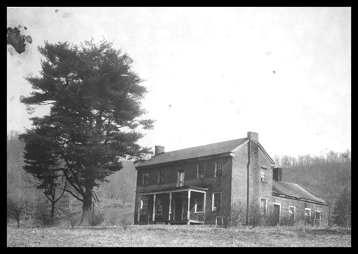
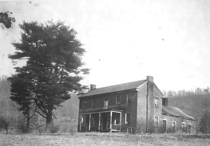
| Here is a photograph of the May House, taken by Tress May Francis in 1936. The house faces the Big Sandy River, the main artery of commerce in the early days. The Pound Gap Road ran along the bottom of the knoll on which the house is located. Traces of the roadbed are still visible today. | |
||||||||||||||||||||||||||||||||||||||||||||||||||||||||||||||||||||||||||
| For a larger version of this photo, click here. | |||||||||||||||||||||||||||||||||||||||||||||||||||||||||||||||||||||||||||
| On January 14th, 1837, Senator Samuel May introduced a bill "to improve the road from Mount Sterling, by way of Prestonsburg, to the Virginia line." A month later the bill was passed and signed into law by Governor James Clark. To fund the project, the Assembly appropriated $25,000. According to Mary Verhoeff, the amount actually spent was $23,243.40. The work was performed by local contractors, including Samuel's brother Thomas May, who was paid $3,000 to improve a seven-mile stretch of the road from Piketon to "the top of Island Hill." The greater part of the work consisted of "grading and draining the worst hills and bridging some of the worst water-courses." Six bridges were built over the Big Sandy between Piketon and Prestonsburg. | |||||||||||||||||||||||||||||||||||||||||||||||||||||||||||||||||||||||||||
| Chapter Seven of Oldest House | Back to Main Page of Archive | ||||||||||||||||||||||||||||||||||||||||||||||||||||||||||||||||||||||||||
| Back to Table of Contents | Friends of May House Page | ||||||||||||||||||||||||||||||||||||||||||||||||||||||||||||||||||||||||||
| Go to Seed-Planting Gallery | |||||||||||||||||||||||||||||||||||||||||||||||||||||||||||||||||||||||||||
| Battle of Middle Creek | |||||||||||||||||||||||||||||||||||||||||||||||||||||||||||||||||||||||||||
| To obtain a copy of The Oldest House in the Valley, Robert Perry's book about Samuel May and the building of the May House, write to Friends of the Samuel May House, P. O. Box 1460, Prestonsburg, Kentucky 41653. | |||||||||||||||||||||||||||||||||||||||||||||||||||||||||||||||||||||||||||
| Maps of towns and counties mentioned in this chapter come to us courtesy of Pam Rietsche and her wonderful 1895 U.S. Atlas, a handy tool for on-line historians and genealogists. | |||||||||||||||||||||||||||||||||||||||||||||||||||||||||||||||||||||||||||
| The beautiful photo of the Old State Capitol in Frankfort comes to us courtesy of Randolph Hollingsworth, Professor of History at Lexington Community College. To learn more about the building, click here. | |||||||||||||||||||||||||||||||||||||||||||||||||||||||||||||||||||||||||||
| H.S. Tanner's 1834 Map of the United States can be found at the Magic Map and Geographic Information Center on the University of Connecticut Server. The map has been broken into sections for more convenient access. | |||||||||||||||||||||||||||||||||||||||||||||||||||||||||||||||||||||||||||
| This page hosted by | |||||||||||||||||||||||||||||||||||||||||||||||||||||||||||||||||||||||||||
| Get your own Free Home Page | |||||||||||||||||||||||||||||||||||||||||||||||||||||||||||||||||||||||||||