 >
>
The Rise of the Plantation and its characteristics
The main reason for the rise of the plantations in the southern mainland colonies and Caribbean was the worldwide need for mass amounts of crops such as sugar, tobacco, and cotton. Rice was no exception to this need. Nowhere could rice be better grown in the British mainland colonies than coastal South Carolina, and plantations arose around Charleston, and Georgetown to mass produce this crop. Mass production was much cheaper than producing small amounts of crops, and the plantations were run as much as a business as any typical business undertaking.
Rice plantations generally varied from 200 to 1000 acres, with the most profitable generally being between 900 and 1000 acres. Most had between 60 and 100 slaves, and were located on terrain not heavily dissected. This was done to keep labor concentrated in large fields where overseeing was much easier. As one may imagine, plantations had a fairly small number of buildings. Both slave quarters and storage buildings were fairly close to the planter so that he could manage his business more efficiently. The coastal rice plantations (which were the vast majority) had this cluster of buildings close to the waterways, as much for efficient transportation as for show. Eighteenth century rice plantations generally had the slave quarters on either side of the entranceway to the plantation on the waterside of the main house. This was done both to keep watch over the slaves and to exhibit the wealth of the plantation to visitors. As the eighteenth century closed, roads were replacing water as the primary means of transportation. Slave cabins were moved to the back or side of the main house, away from the water. Rows of trees now lined the entranceways. Slave drivers generally lived at the end of the rows of slave cabins, and the slave overseers usually lived between the home of the planter and the slaves.
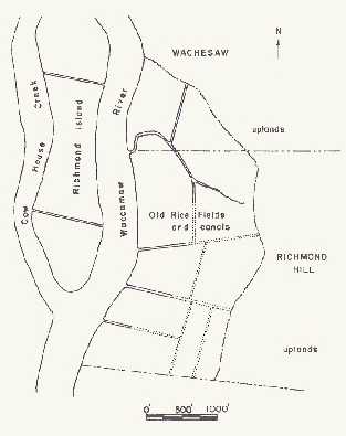
Rice is very dependent on water levels as shown by examining how rice was grown. The entire rice growing system was designed around flood canals. These canals were connected to the river and as well as other smaller canals in a somewhat perpendicular pattern. Floodgates were installed on main canals to maintain water levels in the fields. Dams were often built along the river and on the canals for barges to prevent a change in the water level of the fields. This system ensured stable water levels in the rice fields adjacent to the rivers of coastal South Carolina, most of which were prone to both flooding and falling to low levels. This system of canals and a map of a typical rice plantation can be seen below.
Rice planting was a fairly complex process. After the fields weree tilled, the seeds were usually planted in March and June to lesson the effects of the bobolink, a bird who fed on rice seed. As soon as the seeds had been planted, the fields were flooded to encourage sprouts. When the sprouts appeared, the fields were again drained to encourage the growth of roots. Weeds and other vegetation often would grow along with these rice plants, and water would be let back into the fields to drown this unwanted growth. Then, the fields would again be drained, and a series of plots of approximately one half acre would be established. One slave would have the responsibility of hoeing one of these plots to aerate the soil and keep out weeds. Finally, the fields would be flooded one last time to give the rice a final period of growth. The rice was usually harvested in late summer to early fall, when the crops turned from green to gold. The fields were then drained until the next growing season.
>Both of these images are what archeologists believe Richmond Hill looked like. The straight lines running from the river to the "uplands" are the manmade canals. These canals have given way to a cypress swamp today, and the dams are barely visible from the river. Richmond Hill was a typical coastal South Carolina rice plantation located on the Waccamaw Neck, fronting the Waccamaw River, in northeastern Georgetown County, near Murrells Inlet.
The source of the information and pictures on this page is Michie, pg. 47-52. Pictures, Michie, pg. 49 and 53, respectively.

Front Gates / Table of Contents / Introduction of Rice / Rise of the Rice Plantations / Planters / Slaves / Georgetown County / Geography of Georgetown County / Examples of Plantation Homes / Demise of the Rice Plantations / Gallery of the Abandoned Rice Fields / Explanation of Certain Terms / Links to other sites / Bibliography