Bandar Khayran
Oman
| General | Travel
| Visas | Locations
| Maps, books | Geology
| Snapshots
Bandar Khayran
| Jabal Akhdar | Masirah
| Mountains | Musandam
| Salalah | Seifa |
Wadi Mistal | Wahibah
Mangroves and fish
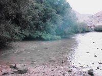
| Bandar Khayran lies 25 km southeast of Muscat.� It is a haven of tidal creeks and sheltered bays fringed in places by mangroves. When the tide retreats, large expanses of sand, silt and mud are uncovered. |  |
 |
To find out why mangrove swamps are important, see this Mangrove Study of the Gulf by Peter Hellyer, and this article by Rob Baldwin in Arabian Wildlife. The Food and Agricultural Organization (FAO) review should give you extra information. Nizwa.net publishes an illustrated feature on mangroves in Oman. All external links will open in a separate window. |
The bay is a favourite resort of Muscat residents who go there to camp, and to dive and snorkel out in the deeper parts.� Local fishermen will provide boat rides.
Many thanks to Khalid from Sultan Qaboos University who provides the following information:
"Bandar Khayran can be reached both by boat and by road. It lies beyond Yiti on the road to Seifa. The bay is the largest semi-enclosed bay on the western coast of Oman with an area of approximately 4 sq km. It is surrounded by steep rocky hills and cliffs, built mainly of Permian limestones and shales, metamorphic pre-Permian sandstone(quartzite) and some Triassic limestone found only on the west island. This island separates the western side from the open sea forming two narrow channels serving as the main inlets to the bay. The maximum depth of the bay is around 16m.
Besides serving as a rich habitat for mangroves, fish and corals, it is also home to turtles and nesting birds such as the white-cheeked tern, osprey and heron. There are several arechaeological sites dating to the pre-Islamic and Islamic periods. More than 200 fish species, most of which are coral fish, and about 40 coral genera live in the bay."
| Here we're looking north from Abdullah's boat to the sea arch (very gently dipping Tertiary sediments) near Bandar Jissah where you can hire a boat to take you to a beach for the day.... | 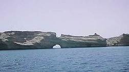 |
 |
Like this one... accessible only from the sea or by foot over very rough terrain. Note that it is pristine. The only facilities will be what you bring with you. And take your rubbish home too. |
| View from the boat into one of the inlets at Bandar Khayran. The rocks bounding the bay are late Permian-Triassic sediments of the Akhdar Group dipping quite steeply northeastward. The geological map indicates two thrust (or reverse) faults in the area. |  |
Link to the following site for a detailed summary of the environment of the Sultanate of Oman which gives useful contact information as well, including the details for the Oman Diving Federation. Oman can provide some very good diving. Holiday-in-Oman and Oman Adventure are well worth investigating for adventure/trekking/diving holidays. They can also arrange hotel packages. Link to scuba diving companies in Oman from this site.
It had to happen! You can take a boat with a submersible bottom which enables you to sit in comfort and watch underwater life in Bandar Khayran. Costing RO25 a ticket, you catch the boat from Marina Bandar Al Rowdha, which lies a couple of miles or so on the coast south of Old Muscat and north of the Al Bustan Palace Hotel.
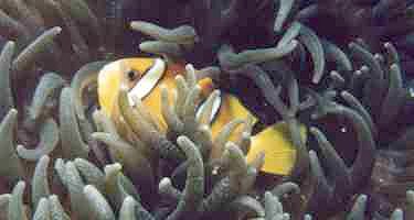
An underwater world
Fish of exquisite beauty live and feed off the underwater
eco-system in the bays.� I'm very grateful to Geoff Armstrong for providing
the following photos.�
�
 |
Adult Emperor Angelfish� Pomacanthus imperator (Bloch, 1787) Copyright: Geoff Armstrong |
| Juvenile Clark's Anemonefish Amphiprion clarkii (Bennett, 1830) Copyright: Geoff Armstrong |
 |
 |
Collared Butterflyfish Chaetodon collare (Bloch, 1787) Copyright: Geoff Armstrong |
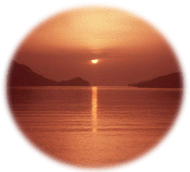
Sunrise
The animation below gives you some idea of watching sunrise
over the bay from one of the beaches accessible by road.

For books about diving, mangroves, tropical fish and underwater photography, link below to visit Amazon.com
Back to Oman for more Off-road pages.
This page designed for 640 x 480 pixel display