Salalah and the Khareef
Oman
| General | Travel
| Visas | Locations | Maps,
books | Geology | Snapshots
Bandar Khayran | Jabal
Akhdar | Masirah | Mountains
| Musandam | Salalah | Seifa
| Wadi Mistal | Wahibah
Desert and Tropics meet
Lying at approximately 18 degrees north, Salalah,
the second town of the Sultanate of Oman and 1,000 km from Muscat, faces
the expanse of the Indian Ocean (see satellite image). The image will open in a separate window. The size is 72.5 K and the file takes up to 30 seconds to download fully at 28.8K.
Images with a brown border are thumbnails. Click on them to see larger versions in a new window.
| The mountains of Jibal Dhofar, which rise to 1,000m, encircle the Salalah plain and stretch westwards into Yemen. Sailors have made landfall on this coast for thousands of years en route from Africa, the Red Sea, India and beyond. |
 |
| The rugged terrain made communications very difficult and the population remains dominated by isolated communities of tribesmen. Following the resolution of the Dhofar rebellion in the early 1970s, a black-top road was built to the Yemen border. It is a highly impressive feat of civil engineering with switchbacks descending to a wadi bottom and up the other side of the valley a few kilometres west of Mughsail. |
 |
A branch of the Royal Family of Oman ruled Zanzibar,
an island off the coast of East Africa, until 1964. The peoples have
freely intermingled and African influences are particularly apparent in
Dhofar, Oman's southern region, of which Salalah is the chief town.
| The ruins of a port, Samhuram, known to have been in its hey day over 2,000 years ago lie on a promontory between two khawrs, or sea creeks, some 30 km east of Salalah. Locally and popularly known as the Queen of Sheba's Palace, Samhuram was important for the trade in frankincense. |
 |
| Frankincense is a resin hardened from
the sap of the frankincense tree, a very unprepossessing plant which grows
only in southern Oman, parts of Somalia and India. Omani frankincense has
the best quality and value.
Travelling westwards from Salalah, stunted trees are spotted easily by the roadside usually growing in wadis, but these are not usually reckoned as yielding good quality resin. Two main crops are taken each year. |
 |
| Frankincense was used very widely in the ancient
world and was prized as highly as gold. Thus the rulers of Dhofar
were accounted very wealthy men.
This Phonecian inscription at Samhuram testifies to a cultured way of life. |
 |
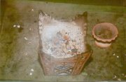 |
Incense being burnt in a traditional Dhofari incense burner as a sign of reverence at the tomb of Prophet Ayoub, which overlooks the Salalah plain. |
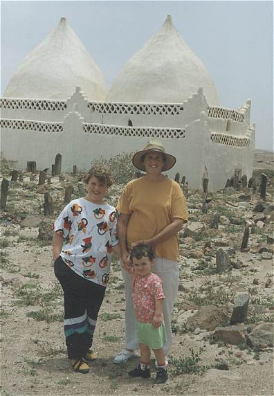 |
Another old mosque just outside
Taqah at the eastern end of the Salalah Plain has two distinctive onion-shaped
domes.
Rosie, George and I are standing at the edge of a graveyard. Omani graves are marked by shattered fragments of rock, some of which may bear inscriptions. |
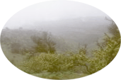
| As this air is lifted over the Jibal Dhofar, the moisture condenses as thick fogs over the hills which support an annual resurgence of many herbs, grasses and trees in this summer season. Many of these plants have been used throughout history for their medicinal properties. |  |
| Salalah depends for its water supply on annual replenishment by the Khareef fogs. Groundwater travels fairly rapidly through the fractured limestone and either recharges the alluvial gravels under the plain or emerges in springs in the foothills, such as this one at Ayn Homran. |
 |
| The people of the region have traditionally been nomadic pastoralists. Flocks of goats and sheep still roam the plain searching for forage. Cattle are kept at higher levels. |
 |
| Camels are very common in Dhofar, regularly following the road to get to where they want. Amazing as it may seem, each camel has an owner even though they may wander over long distances. |
 |
The fog cools temperatures considerably, such that Salalah is a popular destination for Gulf visitors in the summer as a respite from the relentless heat. The phenomenon of this rain-bearing fog is known locally as the Khareef.
 |
No vegetation grows in this wadi on the Salalah Plain, but the moisture-bearing winds of the Khareef green the hills in the distance. |
 |
The Whale's Mouth near Mughsail, west of Salalah. This view towards the sea looks down on the same wadi bed shown in the neighbouring picture. |
 |
A raging monsoon sea. Looking towards the Whale's Mouth from the shore at Mughsail. |
Many of the visitors camp out on the plain north of Salalah, cooking on improvised barbecues. The municipality has been organizing a Khareef festival since 1952 to encourage this tourism.
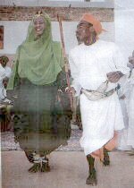 |
The Marbat
dance troupe performed many traditional dances at the finale of the Khareef
festival in 1998.
This picture was taken by a staff photographer of the Oman Observer and was published in 1998. |
| Tourists also visit the blowholes
at Mughsail west of Salalah, where jets of water are forced up through
narrow vents in the limestone rocks. Seas are high during the monsoon
season, and care should be taken swimming.
All the same, this is Yours Truly having a very enjoyable time standing over one of these holes getting wet with the guys! |
 |