SOUTH AUSTRALIA - TOPOGRAPHICAL DESCIPTION 5 ...
Atlas Page 87
By Henry T. Burgess
ACROSS THE GULFS — WESTWARD.
UNDER ordinary circumstances, it is a delightful trip of about two hundred miles to
Port Lincoln by one of the regular steamers. Nearly all the way smooth water may be
generally calculated upon. Rounding the southern extremity of Yorke’s Peninsula, a
fine view is obtained of the rocky Althorpe Islands, with their perpendicular cliffs of
three to four hundred feet crowned with a light-house. Perhaps a little tossing may be
experienced here, but the shelter of Wedge and Thistle Islands is soon gained, and thence
the course lies through a lovely archipelago. Entering Boston Bay, Kirton Point is rounded
and the steamer makes fast to a jetty, seven hundred feet in length, in a perfectly
land-locked harbour four miles across. Boston Island forms a natural breakwater with deep
channels to both north and south, and encloses an area with depth and extent sufficient
for all the navies of the world to anchor in safety. A sight of the magnificent harbour
fully explains the tenacity with which some early colonists clung to the idea of
establishing the metropolis of the colony on its shores. A short excursion inland,
however, shows the reason why it would have been altogether unsuitable. The country is,
for the greater part, extremely poor. There are extensive stony, scrubby, and sandy
tracts, but only a few patches of limited extent, here a and there, that are adapted for
cultivation. The town of Port Lincoln, which contains between five and six hundred
inhabitants, is prettily situated, and is laid Out on an ambitious plan, for the surveyors
had the idea of a city before them, but its crescents and terraces, for the most part,
exist only on paper.  It has three hotels, as many churches, an institute, bank, casualty
hospital, and other public institutions. For a sanatorium, or a place wherein to spend a
quiet holiday, it is almost perfect. Except on steamer-days, there is no hurry of
business, and nothing peculiarly agitating even then. Boating, fishing, and shooting may
be had in abundance. Many points of the scenery are full of interest. It is a rough
scramble to Monument Hill, where stands the obelisk erected by Lady Franklin to the memory
of Captain Flinders, but the view over the bays and islands is an ample reward for the
toil. Port Lincoln proper is another land-locked harbour resembling Boston Bay, and of
great beauty. Sleaford Bay is also worth visiting. A pleasant drive of ten miles northward
along the coast conducts to the mission station of Poonindie, where prolonged and patient
labour on behalf of the aboriginals has had more than ordinary success.
It has three hotels, as many churches, an institute, bank, casualty
hospital, and other public institutions. For a sanatorium, or a place wherein to spend a
quiet holiday, it is almost perfect. Except on steamer-days, there is no hurry of
business, and nothing peculiarly agitating even then. Boating, fishing, and shooting may
be had in abundance. Many points of the scenery are full of interest. It is a rough
scramble to Monument Hill, where stands the obelisk erected by Lady Franklin to the memory
of Captain Flinders, but the view over the bays and islands is an ample reward for the
toil. Port Lincoln proper is another land-locked harbour resembling Boston Bay, and of
great beauty. Sleaford Bay is also worth visiting. A pleasant drive of ten miles northward
along the coast conducts to the mission station of Poonindie, where prolonged and patient
labour on behalf of the aboriginals has had more than ordinary success.
Along the coast of Spencer’s Gulf and also that to the west, there are isolated
and scattered agricultural settlements. Tumby Bay, and Franklin Harbour are among the most
important on the Gulf, and westward a hundred miles from Port Lincoln there is an
extensive area at Elliston. In favourable seasons good harvests have been gathered at
these places, but the uncertain rainfall and the rabbits make farming a precarious
occupation. With these exceptions, the country is chiefly taken up by pastoralists. The
produce of the sheep-runs in the interior finds its way to the numerous bays along the
coast, and thence, as a rule, by small vessels to Port Adelaide. At Coffin’s Bay
—famous for its oysters —Streaky, Fowler’s, and other bays, there are small
settlements; but there is no inland town for hundreds on hundreds of Miles, and the
general features of the country are decidedly unattractive, though many people believe
that much of the great Nullarbor Plain will yet be found suitable for agriculture.
ALONG THE RAILWAYS — NORTHWARD.
FROM Adelaide to Hergott by railway the distance is about four hundred and fifty miles,
almost due north. The lines which branch off east and west reach in all to about the same
total. From Hergott about two hundred and fifty miles more to a point named Angle Pole are
in process of construction. The branch lines westward touch the seaboard at several points
on the gulfs; but it is, nevertheless, fair to say that the northern railway system
includes nearly twelve hundred miles along which the traffic converges to the metropolis.
The present terminus of the authorised works is within about a hundred miles of the
original northern boundary of the province, and their extension on the land-grant
principle through the continent has been recommended by the Transcontinental Railway
Commission.
From Adelaide to Gawler the line runs along a plain which seems almost a dead level,
and which is devoted to agriculture. It passes close by the sewage farm at Islington,
where the dense shrubbery and luxuriant crops at once attract attention, and opposite them
are large railway workshops. At Dry Creek, six and a half miles from town, it is joined by
a loop-line from the Port, which is less than five miles distant, and the heavy-goods
traffic is thus saved the detour to the city. Here also a short line branches off to the
Labour Prison, the buildings of which are seen crowning a hill two or three miles away to
the east. Across the flats, which stretch to the North Arm and look as if they had but
recently emerged from the sea, the buildings and a forest of masts at the Port are visible
against the sky. Twelve miles from Adelaide on the Little Para, the course of which across
the plain is traceable by a line of splendid gum trees, is the quiet town of Salisbury. It
has six churches, three hotels, and a goodly number of business establishments sustained
by the farming district around it, and that of a fertile region among the hills where are
Golden Grove, One-Tree Hill, Uley, and other settlements.
Through Smithfield, a small wayside village, to Gawler there are the same general
characteristics. The line of hills to the east is pretty but not remarkable; to the west
the plain stretches away to the horizon. It is one great wheat-field, with scarcely an
obstruction to the plough except the wire fences that traverse it everywhere, a few
uncleared patches of scrub, and the plantations around the homesteads. In the triangle
formed by the railway, the river Gawler, and the coast, some of the finest wheat in the
world has been grown. The principal town in this area is Virginia, on the old coach-road
to Wallaroo, which is centrally situated and in good seasons is fairly prosperous.
Approaching Gawler, scattered suburbs occupy the bare-looking little plain between the
station and the hills. The well appointed farm to the left is a favourite place for trials
of reapers, harvesters, etc., and has often been chosen for illustrations of the manner in
which wheat is harvested in South Australia. Near the river, the mansion erected by the
late Mr. Duffield, with its extensive vineyard and park makes a pretty picture.
Ordinarily, the main support of the town is indicated by an immense pile of sacks of wheat
adjoining the large Victoria Mills that are close to the station yard. The town, which is
reached in a few minutes by tram, lies in a hollow at the foot of a low range of hills and
is bounded by the North and South Para Rivers, outside which are several suburban town
ships. The head waters of the little streams are many miles apart in the Barossa Ranges,
but they unite Just below the town and form the river Gawler, and the apex of the triangle
thus formed is reserved for park lands, which being enclosed by splendid gum-trees,
judiciously planted, and well cared for, form a delightful and deservedly popular resort.
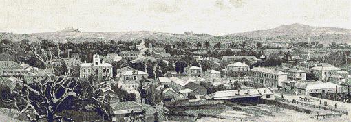
 Murray Street, the principal thoroughfare of the town,
is adorned by several fine buildings, including an exceptionally large and well-equipped
institute, with a hall capable of accommodating seven hundred persons. At the highest part
of it, near the tram terminus, is the monument erected to the memory of John McKinlay, the
famous explorer. There are eight churches, some of which are remarkably fine buildings, a
large public school, several hotels, numerous shops that would not discredit the best
streets of Adelaide, and three of the largest flour-mills in the colony. The business of
the town is chiefly connected with the large agricultural districts of which it is the
centre, but it is also, next to Adelaide, the chief seat of manufactures in the colony. It
has foundries, sawmills, cordial factories, coach-building establishments, and
agricultural implement manufactories, besides others of lesser note. The engineering,
foundry, and machine works of Messrs. James Martin and Company cover several acres, and
are a scene of constant and busy activity.
Murray Street, the principal thoroughfare of the town,
is adorned by several fine buildings, including an exceptionally large and well-equipped
institute, with a hall capable of accommodating seven hundred persons. At the highest part
of it, near the tram terminus, is the monument erected to the memory of John McKinlay, the
famous explorer. There are eight churches, some of which are remarkably fine buildings, a
large public school, several hotels, numerous shops that would not discredit the best
streets of Adelaide, and three of the largest flour-mills in the colony. The business of
the town is chiefly connected with the large agricultural districts of which it is the
centre, but it is also, next to Adelaide, the chief seat of manufactures in the colony. It
has foundries, sawmills, cordial factories, coach-building establishments, and
agricultural implement manufactories, besides others of lesser note. The engineering,
foundry, and machine works of Messrs. James Martin and Company cover several acres, and
are a scene of constant and busy activity.
Gawler has always taken a prominent part in public affairs, and wields much political
influence. It has been dubbed the modern Athens, and the eastern elevation is
appropriately styled Mars’ Hill. Here are several handsome residences with
beautifully laid out grounds, which add greatly to the beauty of the place, and from that
point a charming view is obtained over the town and the extensive western plains. Farther
back is a reservoir, capable of holding three hundred thousand gallons, into which water
is pumped by powerful engines from a deep well in the riverbed, and thence it is
distributed by gravitation. The town is lighted with gas, kept in excellent order by an
energetic corporation, and is altogether one of which its residents are justly proud.
The country eastward is very attractive. For several miles the road winds among the
foothills of the great Barossa Range, which is a continuation of the Mount Lofty chain.
The country is undulating, and mostly fertile. At Sandy Creek, five miles out, the road
divides, and taking that to the right there is a sudden change in the scenery. Within a
mile, sandy and scrubby hills are met with, and if a half-effaced track turning off
through the bush be followed, the traveller will speedily find himself in an extensive but
abandoned goldfield. The surface of the ground is honeycombed, and there are unprotected
holes everywhere. The place was at one time famous as Spike Gully and gold was discovered
there more than twenty years ago. The sinking was shallow, and some claims so rich that
they yielded one thousand pounds per man. It is the commencement of a highly auriferous
tract that extends for several miles southward. The rocks have a remarkable resemblance to
those of some Victorian goldfields. They consist chiefly of metamorphic, argillaceous, and
micaceous schists, with granite, greenstone, and feldspathic dykes. There are numberless
leads and reefs, and in some of the latter a considerable sum of money has been expended.
The Malcolm’s, Barossa, and Lady Alice mines are among the most important. They have
produced both gold and copper to such an extent as to encourage the belief that systematic
prosecution of mining will yet yield remunerative results. Some of the plant, including
pumps and stampers, is still standing, and the fact that from one to two hundred thousand
pounds’ worth of the precious metal has been obtained is held to be proof that there
are large deposits still untouched. The scenery, especially in the near neighbourhood of
the South Para, is often wild and grand. Some distance up the stream the hills on either
side of it shoot out projecting spurs that form a natural gateway, which it has been
proposed to close by an embankment a hundred and fifty feet in height. Were this done, an
inland sea several miles in circumference would be formed, from which the whole of the
Adelaide plains might be irrigated. The project has been favourably reported upon and
submitted to parliament, but from financial considerations it is held in abeyance.
Twelve miles from Gawler, the pretty little village of Williamstown nestles among the
hills just at the entrance to the main range. The traveller may turn southward and enjoy a
delightful drive through magnificently timbered hills and past smiling farms via Kersbrook
to Gumeracha, or keeping westward, reach the high level of the Mount Crawford district,
and so by Pewsey Vale to the Murray plains.  Either way he will have a succession of lovely landscapes and a climate that
has no superior-where English grasses thrive, flowers bloom, and fruits are brought to the
highest degree of perfection. He may perhaps see hares scudding through the fern, flush a
cock pheasant, or startle a deer, for on some of the estates English game has been
successfully introduced and acclimatised.
Either way he will have a succession of lovely landscapes and a climate that
has no superior-where English grasses thrive, flowers bloom, and fruits are brought to the
highest degree of perfection. He may perhaps see hares scudding through the fern, flush a
cock pheasant, or startle a deer, for on some of the estates English game has been
successfully introduced and acclimatised.
The northerly branch of the road that bifurcates at Sandy Creek conducts the tourist
through scenes of much natural beauty and of peculiar interest, for it seems to lead him
into the heart of Germany. It traverses a territory large enough for a European kingdom
that is principally occupied by Germans. Some of the settlements, such as Rosenthal and
New Mecklenburg, suggest this characteristic by their names, and there are many others
where the Teutonic element predominates. All along the roads, the light clattering German
waggons, each drawn by a pair of sleek, well fed horses, are met with going to or
returning from market. Lyndoch and Tanunda are thoroughly German towns, six miles apart,
and the latter seventeen miles from Gawler. Each has Lutheran churches, and at the hotels,
stores, and machinists’ shops the business is transacted by Germans in their own
tongue. There is a German newspaper, the festivals of "the fatherland" are
enthusiastically observed, and the homes and habits of the people exhibit all the national
characteristics. The country picturesque and diversified. To the east frowns the craggy
peak of the Kaiserstuhl, and the luxuriant gardens, blossoming hedge rows, prolific
orchards and vineyards, thriving farms and comfortable homesteads, speak for themselves of
the fertility of the gently sloping hills that stretch for miles in every direction.
German farmers have a high reputation among their fellow-colonists, and their
well-cultivated holding; the excellent condition of their stock, and their industrious
habits prove it to be deserved.
 The road unites with those from Freeling and Kapunda just before
entering Angaston, which derives its name from the Hon. G. F. Angas, one of the founders
of the colony; and Lindsay Park, where he made a beautiful home, is in the immediate
neighbourhood. Angaston is a model country town of perhaps seven to eight hundred
inhabitants. It is very lovely, both in itself and in its surroundings. Its public
buildings, churches, etc., are spacious, substantial, and handsome. It has a hall which
will hold three hundred persons, a good flourmill, and a large fruit-preserving
manufactory. Gently sloping and verdant hills, dotted with fine timber, extend for miles.
Both climate and soil are admirably adapted for fruit-growing, and there are several
hundreds of acres of vines and fruit-trees in the vicinity For those who enjoy a rural
life, Angaston is a place to linger at as long as possible and to leave with regret. A
drive along the route that has been described, returning to Gawler by way of Shea-oak-log
and Willaston, is one that even a travelled tourist will be likely to remember as long as
he lives.
The road unites with those from Freeling and Kapunda just before
entering Angaston, which derives its name from the Hon. G. F. Angas, one of the founders
of the colony; and Lindsay Park, where he made a beautiful home, is in the immediate
neighbourhood. Angaston is a model country town of perhaps seven to eight hundred
inhabitants. It is very lovely, both in itself and in its surroundings. Its public
buildings, churches, etc., are spacious, substantial, and handsome. It has a hall which
will hold three hundred persons, a good flourmill, and a large fruit-preserving
manufactory. Gently sloping and verdant hills, dotted with fine timber, extend for miles.
Both climate and soil are admirably adapted for fruit-growing, and there are several
hundreds of acres of vines and fruit-trees in the vicinity For those who enjoy a rural
life, Angaston is a place to linger at as long as possible and to leave with regret. A
drive along the route that has been described, returning to Gawler by way of Shea-oak-log
and Willaston, is one that even a travelled tourist will be likely to remember as long as
he lives.
GAWLER TO MORGAN.
The railway crosses the river Gawler on a substantial bridge that has the very minimum
of ornament, but from that point there is an excellent view of the town. Thence for five
miles to Roseworthy the gradients are rather steep; there is good farming country all the
way, which is pleasant enough, but has no special features to attract attention.
Roseworthy is an important junction, for there the northern railway and that to Kapunda
and Morgan separate, but as a town it is a failure. About three miles distant on the
plains to the west are the substantial stone buildings of the Agricultural College, which
stand in an experimental farm of over eight hundred acres, and are designed to accommodate
forty pupils. It is a valuable and important institution, and attracts students from
various parts of South Australia, from the other colonies, and even from Fiji. Seven miles
from Roseworthy is the town of Freeling, planted on an extensive plateau six hundred and
twenty-seven feet above the sea. Rolling downs stretch for miles in every direction, the
soil is principally a clayey loam on a limestone formation, and with an average rainfall
bears excellent crops. The town is bright and cheerful. It has a good hotel, a neat
church, several wheat stores, shops, etc., and contains from two to three hundred
inhabitants. A road which leaves the railway at right angles, after crossing a fertile
valley, enters the low hills where Seppeldsfelt is situated. There is here a large wine,
vinegar, spirit, and cordial manufactory, with an extensive vineyard. It is a pretty spot,
and the premises are thoroughly complete. A few miles further Greenock is reached, which,
in spite of its Scotch name, is a German village about as large as Freeling.
Comfortable-looking houses and gardens gay with flowers line the road side, and on the
hill slopes a good deal of heavy timber still remains. For some miles the road from Gawler
to Kapunda has been followed, but turning off to the east, through about four miles of
hilly and timbered country, it enters Nuriootpa, a other town which, with the surrounding
country, is principally German. It was established in the earlier days of the colony, and
has a somewhat old fashioned appearance. 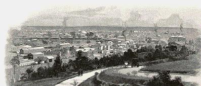 The houses are embosomed in flowers and large
fruit-trees, and all vegetable products are in abundance. All round is a splendid farming
country, and there are about forty thousand acres devoted to wheat growing in the
district. The roads are bordered by high gum-trees which form lengthy avenues, and large
numbers of forest giants still stand in the cornfields.
The houses are embosomed in flowers and large
fruit-trees, and all vegetable products are in abundance. All round is a splendid farming
country, and there are about forty thousand acres devoted to wheat growing in the
district. The roads are bordered by high gum-trees which form lengthy avenues, and large
numbers of forest giants still stand in the cornfields.
After leaving Freeling, the railway continues to ascend till it crosses the watershed
between the valleys of the Light and the North Para. Wheat fields stretch in almost
unbroken continuity nearly to the horizon. Right in front, the bold face of the range
overlooking the valley of the Gilbert has the appearance of a solidified wave three or
four hundred feet in height. Passing the handsome stone station at
"Ford’s," —which seems to exist for the sake of the only farmhouse in
sight —the line enters the valley of the river Light, and there is a succession of
picturesque views as the train rushes along forty or fifty feet above the margin of the
stream, which it finally crosses on an excellent bridge about a mile from Kapunda. The
railway station at Kapunda is seven hundred and fifty-five feet above the sea level, and
is at the lowest part of the town. The effect of the altitude is noticeable in the
character of the atmosphere. The climate is pleasant, the nights are usually cool, even in
summer, and statistics prove the neighbourhood to be one of the healthiest in the colony.
Kapunda was first a mining settlement, then an agricultural township, and subsequently
became a manufacturing centre. The changes it has experienced are visible in its
buildings. Some of the mined’ cottages remain; there are several large wheat-stores
and agricultural implement manufactories. For a country town, the main street is imposing,
the banks, hotels, and post office being handsome edifices. The material generally used is
a kind of soap stone, easily worked, but durable; and six of the seven churches, the
court-house, and other buildings, are creditable specimens of architecture. The town is
lighted with gas; it obtains its water-supply from a reservoir holding a million gallons
at Taylor’s Gap in the ranges five miles away, has a good hospital, a large
flour-mill, an institute, and local newspaper. Evidences of prosperity are furnished by
the unusual number of elegant private residences, with their handsome gardens. Much
attention has been paid to adornment. In the centre of the town is a reserve, where an
attempt has been made to have a sheet of ornamental water, and it is rendered attractive
by willows and shrubbery. Besides this, there is a recreation ground of forty acres, where
cricket matches, etc., are held, and tree planting has wonderfully altered the formerly
bare aspect of the hill-sides. The scenic effect, especially to the south and west over
broken, diversified, and wooded country, is really charming.
From the brow of a little hill, close to the main street, the old mine workings are to
be seen. Gaping shafts, vast quarries, huge masses of chalky-looking refuse, with green
and yellow copper-stains everywhere, and some wreckage of mining plant, tell of past
activity, but in their present desertion make a dismal picture relieved only by the pretty
gardens attached to some of the mine cottages that are still occupied. The large marble
quarries that are being utilised for the Parliament Houses in Adelaide are about two miles
away to the eastward. Northward, there is a fine agricultural country for many miles on
both sides of the old mail road, which leads through the pretty villages of Allendale,
Hamilton, Steelton, and Waterloo. Eudunda is by rail nearly twenty-one miles from Kapunda,
and sixty-nine from Adelaide. The country traversed by the line is undulating, and mostly
fertile. Over a considerable portion of it there are evidences that it was formerly
cultivated, but to a large extent agriculture has given place to sheep farming, and the
population is now very scanty. The town lies in a curving valley on the eastern slope of
the ranges, and is the highest station between the city and the Murray, having an
elevation of thirteen hundred and fifty feet. It is a busy little place, for it is central
to a vast pastoral and agricultural region, and despatches enormous quantities of
firewood, from the scrub-lands near, to the city’. It has a large implement
manufactory, two flour-mills, two banks, two hotels, police-station and courthouse, public
school, five churches-two of which belong to the Germans- about a hundred and seventy
inhabited houses.
 From point to the Murray there is little to attract the spectator.
The line for many miles is perfectly straight, and runs between walls of mallee scrub, as
if at the bottom of a trench. There are occasional clearings in the scrub, but the supply
of this excellent fuel, stacks of which are to be seen at the sidings, seem practically
inexhaustible. There is a down grade nearly all the way, and the Morgan station at the
northwest bend of the Murray, which is one hundred and five miles from Adelaide is only
forty-one feet above the sea-level.
From point to the Murray there is little to attract the spectator.
The line for many miles is perfectly straight, and runs between walls of mallee scrub, as
if at the bottom of a trench. There are occasional clearings in the scrub, but the supply
of this excellent fuel, stacks of which are to be seen at the sidings, seem practically
inexhaustible. There is a down grade nearly all the way, and the Morgan station at the
northwest bend of the Murray, which is one hundred and five miles from Adelaide is only
forty-one feet above the sea-level.
The visitor to Morgan usually turns, in the first place, to the river. It is a noble
stream about three hundred yards wide. On the right bank are cliffs about forty feet high,
and on the left, open park-like country, heavily timbered in places, sloping gradually to
the water’s edge. At the wharf, which is nearly four hundred feet in length, and
furnished with four steam cranes, one or more river-steamers may usually be seen, for
through its rail communication with the city Morgan attracts most of the traffic on the
lower Murray, to the detriment of the river ports at Blanchetown, Mannum, Milang, and
Goolwa.
The township contains three to four hundred inhabitants. It is pleasantly situated on
the lightly timbered plateau in the rear of the cliffs that overhang the river, and has
the usual complement of hotels, stores, and public buildings. Some of the warehouses and
other business premises are both spacious and substantial. A Chinaman’s well-stocked
garden, from which steamers are supplied with vegetables, testifies to the fertility of
the soil and the productiveness that may be obtained by irrigation.
There is good sport for shooting and fishing, parties, and a highly enjoyable trip may
be made up the river to the irrigation colony that is being founded by the Messrs. Chaffey
near the border. Reminiscences of Captain Sturt, Captain Cadell, and other explorers will
crowd thickly on the memory of the tourist, and he will be convinced that, by utilising
the Murray valley, a wonderful augmentation of prosperity will sometime or other be
brought to South Australia.
cont...
click here to return to main page