

G.P. Gibson; H.T. Taerum; J. Pulford; F.M. Sparfford; R.G. Hutchinson; G.A. Deering; R.D. Trevor-Roper

H.M. Young; C.W. Roberts; D.T. Horsfall; V.C. MacCausland; L.W. Nichols; G.A. Yeo; W. Ibbotson

W. Astell; F.A. Wile; J. Kinnear; D. Hopkinson; A.A. Garshowitz; F.A. Barbas; R. Bolitho

D.H. Maltby; V. Nicholson; W. Hatton; J. Fort; A.J.B. Stone; V. Hill; H.T. Simmonds

D. J. Shannon; D.R. Walker; R.J. Henderson; L.J. Sumpter; B. Goodale; B. Jagger; J. Buckley
R.N.G. Barlow; P.S. Burgess; S.L. Whillis; A. Gillespie; C.R. Williams; H.S. Glinz; J.R.G. Lidell

G. Rice; R. McFarlane; E.C. Smith; J.W. Thrasher; C.B. Gowrie; T.W. Maynard; S. Burns

V.W. Byers; J.H. Warner; A.J. Taylor; A.N. Whitaker; J. Wilkinson; C.McA. Jarvie; J. McDowell

W.H.T. Ottley; J.K. Barrett; R. Marsden; T.B. Johnston; J. Guterman; H.J. Strange; F. Tees

K.W. Brown; D.P. Heal; H.B. Feneron; S. Oancia; H.W. Hewstone; D. Allatson; G.S. MacDonald

H.E. Maudslay; R.A. Urquhart; J. Marriott; M.J.D. Fuller; A.P. Cottam; W.J. Tytherleigh; N.R. Burrows
J.V. Hopgood; K. Earnshaw; C. Brennan; J.W. Fraser; J.W. Minchin; G.H.F.G. Gregory; A.F. Burcher

H.N. Martin; J.F. Leggo; I. Whitaker; R.C. Hay; L. Chambers; B.T. Foxlee; Sereant T.D. Simpson

J.L. Munro; F.G. Rumbles; F.E. Appleby; Sergeamt J.H. Clay; Office P.E. Pigeon; W. Howarth; H.A. Weeks

J.C. McCarthy; D.A. MacLean; W.D. Radcliffe; G.L. Johnson; L. Eaton; R. Batson; D. Rodger

L.J. Burpee; T. Jaye; G. Pegler; J.L. Arthur; L.G. Weller; W.C.A. Long; J.G. Brady

L.G. Knight; H.S. Hobday; R.E. Graystone; E.C. Johnson; R.G.T. Kellow; F.E. Sutherland; H.E. O'Brien

W.C. Townsend; C.L. Howard; D.J.D. Powell; C.E. Franklin; G.A. Chalmers; D.E. Webb; R. Wilkinson

C.T. Anderson; J.P. Nugent; R.C. Paterson; G.J. Green; W.D. Bickle; E. Ewan; A.W.Buck
Navigating with just paper maps in WB is a simple process, however it
needs some preparation in advance and a little concentration in flight.
It also needs a belief in your own abilities, especially when you've been
flying over the North Sea for 10 minutes and still haven't sighted land.
This document will give you a overview of how to navigate
to and from a target without using the WB satellite map.
2. Tools of the Trade
Get yourself some good paper maps. Whilst Glars Maps are great for the
keyhelps, for paper maps you really can't beat Max Overlays. Go and pick up a set. My preference is the two-page ETO printout, as it works
with his navigation aids.
You will also need a protractor, a pen and paper. The protractor
can also be picked up from MaxOverlays, but you'll have to get the pen
and paper yourself.
3. Overview of Navigation
Navigating in this context is simply the process of getting your aircraft from your base to the target and back. It uses simple principles, based on distance travelled in a particular direction.
For example, if you lift from F9 in the ETO, fly at 045
degrees for 17 miles, then turn and fly at 090 degrees for 32 miles, you
will reach Rotterdam. You don't need to look out of the window to know
this.
Unfortunately, your aircraft doesn't come equipped with a mileometer, so if you wanted to fly from F9 to Rotterdam along this route you will need to be able to estimate how far you have flown. This is simple in theory.
My schoolboy maths lectures tell me that the distance travelled is equal to the speed of travel multiplied by the time you spend travelling at that speed. For example, if you fly at 200 kts (knots = nautical miles per hour) for two hours, you will have travelled 2 x 200 = 400 nautical miles.
Similarly, if I want to fly 17 miles at 200 kts, I have to fly for 20/200 = 0.085 hours, or 5 minutes 6 seconds. So, to fly from F9 to Rotterdam, we could say: Fly at 045 from F9 at 200 kts for 5 minutes 6 seconds, then turn to 090 and fly at 200 kts for 9 minutes and 36 seconds.
And that's it. Divide your route to the target and back in to manageable steps like this and you've written yourself a route plan that you can follow to get from A to B without ever looking outside your aircraft window.
Simple in theory, but difficult in practice, as you need to keep at an accurate speed and heading. Add wind to the equation and there's a huge potential for error. So, even though you don't need to look out, it's a good idea to visually identify landmarks to make sure you are where you think you are, and make corrections to the heading where needed.
4. Preparation
You can do as little or as much preparation as you like.
If you're just off on your own for a short solo jolly you can hop into an aircraft with no preparation at all. Raids which are good for this are attacks on ports or coastal towns, where the shape of the coastline gives obvious visual clues as to where you are.
As your targets get further and further inland, and as you get lower and lower, more preparation is needed, as well as more accurate flying.
The reason for this is simple. For a short raid at altitude of 10k or more, an error in heading of five or ten degrees will be no big problem as you will still be able to ID your target from a distance and make adjustments to get a good bomb run.
As you go deeper and deeper, heading errors put you further and further from your target. As you get lower and lower, the horizon gets closer and closer to you're a/c, and your visible range decreases. This makes it less easy to ID the landmarks and your target.
For the Dambusters raid, we're going to be doing a very low level raid deep into the German heartland. Preparation is essential.
4.1 Basic Preparation
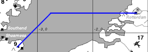
For many missions you don't need to worry about speed, distance travelled and time taken. You can assign a start point and a series of visual waypoints to get you from A to B and back. As an example, a simple mission might be to bomb the port of Rotterdam. The plan might be as follows:
The above is a simple plan which allows you to navigate using visual clues to hit your target and return to base. It produces a planned route like this:
4.2 Thorough Preparation
When flying at very low level, or if planning turns over featureless terrain (eg water, or the farmland of central Europe) you need to know when to turn to your next heading. This is where planning gets more complex and flying the mission becomes more difficult.
The basic process is the same as when making up a basic plan (above). Simply decide where you want to go, how you want to get there, and how you want to get back.
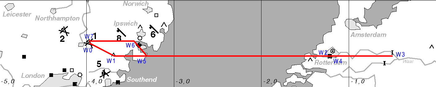
I find examples illustrate the point best, so lets plan a mission from Duxford (F2) to hit the oil storage facility south of Paris. We're going to use the Mosquito F/B and make one run on the target at low level before bugging out back to base before the enemy can respond.
There is no obvious safe route in and out. There are fields (with fighters and acks) to be avoided, as well as the acks at ports and other defences at Caen and Rouen. We need to be a little creative to get to the target, pass overhead, and egress safely.
Lets see if we can find a safe and easy route. Remember, as there are few visual features we're going to have to be making timed runs and turns, so we want to keep the route as simple as possible, with ample time to prepare for each turn.
This is what I came up with:

As you can see, the plan involves a mixture of timed and non-timed legs. 21 minutes will be on timed legs, which will be 100% concentration, looking at the stopwatch, adjusting the throttle to maintain the correct speed, looking out for known landmarks, staying on the correct heading, making minor course adjustments if needed, as well as flying the aircraft below radar and avoiding ploughing in to the ground.
Your pilot is a vital asset - having him take care of flying the aircraft will make your job easier - as long as he stays at the correct speed and on the correct heading. If he doesnt, youre in trouble.
5. Practice Missions
If youre going to navigate using paper maps youre going to have to practice. It simply wont work if you hop in to the a/c and hope for the best. The RAF spends a lot of money training navigators, and with good reason. It requires concentration, and the lives of the entire crew depend on him. After all, you dont want to accidentally fly over the enemy ack in stead of around it, do you?
Go here to find the practice missions.
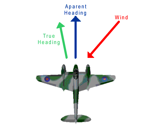
6. Wind
Everything Ive said above assumes that there is no wind. If there is wind, it becomes more tricky to plan and more important to follow the flight plan accurately. Speed and heading become much more important, as changes to either will throw you off your planned route.
Without wind, if you fly too fast you simply arrive at your waypoints early. With wind, if you fly too fast you arrive too early and in a different place than you expected. Historically, bomber crews estimated wind in flight. We dont have that facility in WB, so we must know beforehand what the wind is to plan our flightpath.
Wind affects an aircrafts heading and speed. If you fly in to the wind, your ground speed will be lower for a given airspeed, and if you fly with the wind then ground speed will be higher for a given air speed.
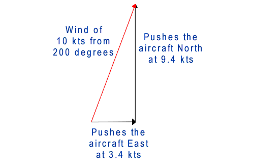
The effect of the wind can be broken down into manageable components, thus if we have a wind that is blowing at 10kts from 200 degrees (slightly West of South) it will tend to blow our aircraft both North and East as follows:
These effects mean that we have to change our heading and timings in order to fly the same route at the same indicated air speed (note: whilst the air speed will read the same in the cockpit, the speed over the ground will vary depending on the wind and your heading).
The maths involved in determining ground speed and actual heading in wind conditions involves some simple trigonometry and vector calculations. The trick in deriving the formulas is to work relative to the known aircraft heading, rather than relative to fixed compass directions, and build up triangles of forces for the aircraft and wind. This all sounds rather daunting if you're not familiar with the maths, however I've developed a few useful tools to help. Go to the Tips and Tools page to find formulas, wind correction tables and an Excel spreadsheet to make it easy for you.
7. Altitude
The information above is accurate only at low level. If you climb, altitude affects your indicated air speed in the cockpit, so that the true air speed is actually greater than the indicated speed. This must also be compensated for, and I will be developing this section later to give more information on this.
8. Accounting for Turns
The process of turning an aircraft can affect the timings over very short missions (ie, the type we normally fly in Warbirds). It is possible to take account of this, and I may update this page later with more info.