
This page contains 'Tools', such as Wind Correction Tables, and 'Tips', such as how to fly at the speed requested by your flight plan. I'll try to update it whenever I hear (or discover) new tips to help, or whenever I develop and new tools to aid the navigator.
Topics on this page are:
1. How To Fly At The Correct Speed
2. How To Fly An Accurate Course
3. How To Correct For Wind
4. I'm Lost! What Do I Do?
1. How To Fly At The Correct Speed
The air speed indicator in the cockpit is rather inaccurate - it is easy to be +/- 10 kts without realising it. I've found that using auto trim on speed can help. I use it like this:
1. First, I fly at what I think is the correct speed as stated on the cockpit dial
2. I type '.speed 300' (or whatever speed I want to be flying at) to set up the auto-trim
3. I then engage 'trim on speed'
4. Now, look at the altimeter. If I'm truly flying at the right speed the altimeter will be rock-steady. If I'm flying too fast, the a/c will tend to climb, so disengage trim and reduce throttle. If I'm flying too slow, the a/c will tend to loose altitude so disengage trim and increase throttle.
5. Repeat as necessary.
The above is a great way to accurately detect and correct small variations in aircraft speed. Pilots, I'd really recommend you try this to help your navigator, as flying at the pre-planned speed is essential to ensure that you make your turns accurately. The ASI gauge is not up to the job.
2. How To Fly An Accurate Course
The compass in the pilot's position is not as accurate as we would like. However, the gunners are provided with exact digital readouts of heading.
Navigators - I would suggest you check your pilots heading by looking at your repeater in the astrogation dome (mid-upper gunner's position) and give corrections as necessary.
Gunners, you can provide an additional check.
It's actually impossible to fly at 090 degrees. You end up at 089 or 091. The other compass point headings (N, S, W) are fine.
3. How To Correct For Wind
Wind increases a navigators problem considerably. Any increase or decrease in speed could throw you off course, and corrections to put you back on track can be difficult to compute. Help is at hand, however. I have prepared some formulas that you can use to calculate heading and ground speed in a wind condition, as follows:
3.1 I Know What Direction I Want To Fly In - What Should my Compass Read?
Knowing:
Sw : Wind speed
Sa : Indicated air speed
Hr : Required heading (direction of travel)
Hw : The direction the wind is blowing from
You can determine the steered heading (cockpit readout) and actual ground speed as follows:
Steered Heading:
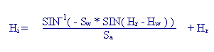
Ground Speed:

3.2 I Know What Direction My Aircraft Is Pointing - What Direction Am I Flying In?
Knowing:
Sw : Wind speed
Sa : Indicated air speed
Hi : Indicated heading (direction of travel)
Hw : The direction the wind is blowing from
You can determine the actual heading and the ground speed as follows:
Actual Heading:
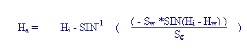
Ground Speed:

3.3 These Formulas Are All Very Well, But My Maths Is Rusty
Unfortunately, to be an effective navigator you should have some basic maths skills. The military set a high standard for navigators, and with good reason - lives are at stake.
In WB there is less real pressure, nevertheless if you need to correct a mistake you will have to do some complex calculations in a very short period of time. Familiarity with the basics (ie the formulas and their derivations using vector maths) can be an immense asset.
Having said all that, I have prepared some useful charts and utilities that can help you.
First off, I have prepared an Excel spreadsheet that contains wind correction tables and a calculation sheet that will quickly spit out the results from the formulas above. You can download this here.
Next, I have individual copies of the wind correction tabes. The tables contain two rows of data for each aircraft heading / wind direction combination. The first row is heading, the second row is ground speed.
Table 1: Knowing what direction I want to fly in, what direction should I point my aircraft? Download as a .txt or .csv file.
Table 2: Knowing what direction my aircraft is pointed in, what direction am I flying in? Download as a .txt or .csv file.
4. I'm Lost! What Do I Do?
Navigators keep logs, to help them get back on track if they get lost. You should too, otherwise if you get lost you will only find the target (or home) with luck.
Your log should consist of a regular recording of time, speed, heading and 'notes'. 'Time' should be eiher absolute time (GMT, EST etc) or time since mission start. 'Notes' should be short jottings of any interesting landmarks or other reference points (eg 'Antwerp visible to port' or 'Turning at waypoint 4). If you can, you should also try to plot your position on a paper map every time you make an entry in your log.
By 'regular recording' I mean at every waypoint, at every landmark, when you take damage, when you begin evasive manoeuvers (and as often as possible during evasive manoeuvers), every time you change course or speed, and every two minutes during flight (or more often if you can).
All the above is hard work for the navigator, but if you get lost it will provide the information you need to get back on track. Simply backtrack along the route you have recorded as having flown until you get to a point you recognise, and start again. Alternatively (if you have plotted your course on a paper map) you can plot a shorter route back to a known point.
Keeping a navigators log isn't required - it's just a common-sense approach to help you recover from errors.