![]()
![]()
![]()
![]()
![]()
![]()
![]()
![]()
![]()
![]()
![]()
![]()
![]()
![]()
![]()
|
|
|
|
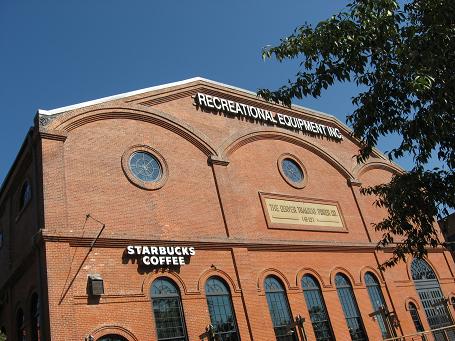
Denver's Downtown Flagship REI DISCLAIMER – SCRAMBLES IN THE MOUNTAINS HAVE INHERENT RISKS AND THE MATERIAL PRESENTED HERE IS INTENDED TO PROVIDE INFORMATION TO HELP A SCRAMBLER AVOID ONLY SOME OF THE RISKS. VARIABLE WEATHER, CHANGING ROUTE CONDITIONS, POOR DECISION MAKING, ILL PREPAREDNESS ETC. CAN CONTRIBUTE TO SERIOUS INJURY, EVEN DEATH. SCRAMBLERS USE THIS MATERIAL AT THEIR OWN RISK AND THE AUTHOR DISCLAIMS ANY LIABILITY FOR CONSEQUENCES THAT COME ABOUT IN SCRAMBLING THESE PEAKS. Colorado Fourteeners – Trip 4 August 9 – August 18, 2008 Victoria is going to do a write up of our enjoyable and jam packed trip. Good scrambles, good Mexican food and good gear stores! Highlights were camping at the radio towers and doing Mt Princeton as well as Mt of the Holy Cross. Visited the Bent Gate in Golden and Tommyknockers Brewery and Pub in Idaho Springs. A few photos in the mean time.
Chipotle at Loveland
Near Buena Vista
REI Boulder
Tommyknocker Brewery and Pub at Idaho Springs
Mini Haagen Dazs not available in Canada! Colorado Fourteeners – Trip 3 August 13 – August 25, 2007 It certainly seemed that this year circumstances were against a trip to Colorado. In November of 2006 I watched my Dad pass away at the age of 86 after a month in the hospital. Yikes, make sure you get right with God before you face your own inevitable demise. That payment that the Lord made in God’s courtroom on your behalf is available for you. Make sure you count the cost though so its real. Next, I was injured and trying to recover from December until May 2007. Thought hiking and scrambling was out for sure at one point. Then the shock of hearing that "Talusmonkey" a young energetic man who had climbed all the Fourteeners in only 2 seasons had died in a fall on Humboldt. I still shake my head when I think about that. Next, my 14er companion Victoria went to train as a camp counselor for 6 weeks at Crowsnest Lake Bible Camp and came back a little exhausted and didn’t want to do a trip to Colorado. So things looked a little bleak but in June and July I did begin to do a few hikes to test the body and each hike seemed better than the one before so I began to have some optimism that a trip was possible but solo? In many circumstances going solo can be boring and depressing and lonely but when I weighed the type of trip I was planning to do I felt that I wouldn’t really be doing much outdoor stuff alone as there would be many people on the trail so I decided to go and shoot for 5 peaks, Mt Evans, Huron Peak, Missouri, Yale and Longs Peak. My surmising proved correct. On Mt Evans I met Rachel and Mark on the trail and Cory at the Echo Lake campground. I had good conversations with them. On Huron peak I walked the 4x4 road with Andy. On Missouri I met and hiked with Lance and Aaron and we went to Coyote’s Cantina for food afterwards. On Yale I met Greg and gave him some beta on the Harvard/Columbia double that he appreciated. On Longs Peak I met Reinar from Germany in the campground and then climbed Longs Peak with about 50 other people with quite a bit of socialization on the route. So, yes, a solo trip can work and be quite enjoyable to Colorado. Now as for beta on planning your own trip I scouted out a few more areas. Still went to Chatfield State Park in south Denver to camp for a night to do laundry and have a shower. Found an easy route to get to the downtown REI. From Chatfield I went north on Federal Boulevard with a right on West 23rd Avenue which goes under I-25 becomes Water Street and plunks you right into the parking lot of REI. Checked out the REI Quarterdome tent but it was too cramped for a 2 man tent IMO, more a one person tent with gear. The listed length and width are exaggerated perhaps a listing mistake. I did pick up a Sierra Designs Microlight nylon wind shell for $32. Nice drawstring and hood and proved to be a very good piece for some of the windy parts of my hiking vacation. In fact I was able to wear it most of the time with just a hiking shirt underneath without heating up too much. Good all round use shell much like my Marmot Driclime jacket. In Denver I tried out the "Mexican Chipotle Grill" on Colfax Avenue but I was not overly impressed. I would give it 6.5 out of 10. I had the shredded beef burrito. The salsa seemed a little bit too harsh in flavor. I may have to go back and try another entrée and different salsa. On a day off between the Missouri and Yale scrambles I went to Aspen to Ute Mountaineering and picked up a really cool 20 litre Camelbak pack that comes with its own rain cover for $90. The model is called the Asymetrix 20, comes with 100oz bladder. Also picked up a pair of Tecko Ultralight crew merino wool socks for $17 that were thin but just right for my hiking boots. Did I mention Chalk Creek campground near Nathrop just south of Buena Vista? A good place to stay for showers and laundry. I also made a visit to Salida which is 23 miles south of Buena Vista. There is a great café in Salida next to Absolute Bikes called Bongo Billy’s Salida Café. They have a nice patio right next to the Arkansas River. Salida also has a Burger King on the main strip coming into town from the east. The area that I had not been to before was Boulder, Longs Peak and Estes Park. I only spent an afternoon in Boulder but I did mange to visit a couple of really good outdoor shops, gear head that I am. The Mont Bell shop on 28 Street and Canyon Boulevard (Burger King right here as well, mmmm Angus burgers) is a must visit as well as Neptune Mountaineering which is on South Broadway in the Table Mesa area. From here it was back to the Longs Peak area as I had paid for a couple of nights ($20/night no showers) at the Longs Peak campground which is only 1/8 mile from the Longs Peak trailhead. Public showers are available 2.8 miles down the road at the Meeker Park Lodge only $3. My other rest day I visited Estes Park which is only 11 miles north of the Longs Peak area turnoff on highway 7. Estes Park seems like a typical touristy mountain town with lots of T-Shirt shops and restaurants. I went to Starbucks in the morning and toured a couple of pretty good outdoor shops, Trailridge Outfitters close to Starbucks and the Estes Park Mountain Shop Outlet Store on Big Thompson Avenue. Starbucks has a nice patio with a creek or some say river flowing by. I tried Penelope’s World Famous burger place. The burger was only average at best but the fries were great, a little pricey at $8. So, that’s a wrap on another good trip to Colorado with lots to see and do. Longs Peak is a classic and I see why people keep coming back to this mountain. Colorado Fourteeners – Trip 2 July 24 – August 14, 2006
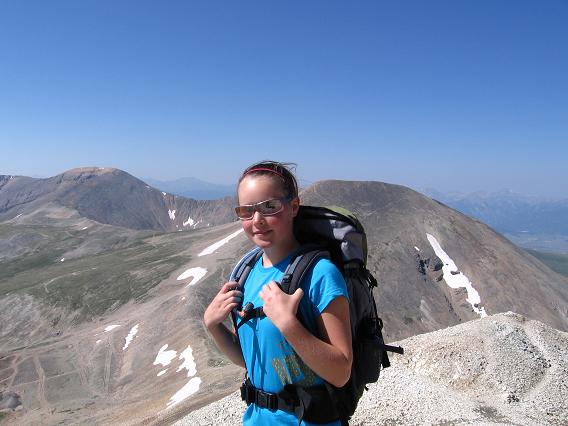
My daughter Victoria on the Summit of Mt Sherman with Mt Sheridan (13er) behind her Well, by God’s grace we made another safe and enjoyable trip to Colorado and 14er land. It’s around 1,100 miles to Denver from Calgary. We drove it in 2 days heading SE through Great Falls, Montana, on secondary highways 87, 191, 3 to Billings, Montana. From there we headed south on Interstate 90 for a short distance before I - 90 heads east, but keep going south on highway 25/87 which goes all the way to Denver. The first 1,000 miles of the trip was through fairly flat and mundane terrain which is easier to drive then mountainous twisty terrain. We did not really see mountainous terrain until 100 miles north of Denver. On this trip starting on Monday July 24th I drove over 900 miles the first day to just past Casper, Wyoming. We stopped at a "Rest Area" and crashed in the car. It seems that this is common at these rest areas. Truckers, cars, and even the odd motorcycle can be found here all going low budget on the sleep accommodations. When I woke up and went to use the washroom I observed a biker using his elbow as a pillow and sleeping on a hard bench in just his leather jacket and jeans. His Harley was an older model which I am sure was a bit of a boneshaker and just wore him out. That’s roughing it! So, on Tuesday July 25th we avoided the famous Denver rush hour traffic and headed west on I-70 out of Denver for half an hour to take the Georgetown exit to Guanella Pass for the trailhead to Mt. Bierstadt. From this trailhead you can do both Bierstadt and Mt. Evans via the Sawtooth ridge. From the summit of Bierstadt I was tempted to do Mt. Evans also but have just driven 1,200 miles and realizing that there was a long trek back from Evans through the swampy willows I deferred to another time. I did not want to do myself in the first day I got there. We planned a day of shopping at REI in Denver so we picked up a map of Denver and looked for a place to camp and sleep low then do some shopping the next day. Coming back into Denver on I-70 you can take exit 269a which is on the west side of Denver and hop onto Wadsworth Boulevard heading south. Wadsworth Boulevard runs south for a long ways right into Chatfield State Park where you can camp. Just follow Wadsworth all the way and it will take you into Chatfield. As we drove down Wadsworth we spotted the south REI store and a Starbucks, our stops for the next day. Chatfield itself is a reservoir setup for use by boaters and the roads throughout the park seem to draw a lot of cyclist’s. The amount of trees weren’t up to what I thought should be there but for a one night stop it had good washrooms and a central shower building. With the amount of water there a lot more trees need to be planted. Anyways, a good location for visiting the south REI and any other store (Best Buy, Circuit City, Walmart etc) for that matter along Wadsworth. We were happy to spot the south REI as it simplified going into and out of Denver and we didn’t have to try and get downtown to visit the REI store there. So we had a leisurely day shopping. Vicky picked up a very nice green Marmot Precip Plus jacket at REI. The Precip Plus in addition to the DWR coating on the outside has a waterproof breathable barrier on the inside as well but you pay a bit more which I think is worth it. The regular Precip has just the DWR coating which would need to be regularly redone. The REI store I think has lost their focus a bit on the type of items they carry. There seems to be less hard core mountaineering items and hard core name brand stuff. Like, I couldn’t even find a clothing item made with Goretex XCR. Their shoe selection also seemed a little on the lite side. I would have been really tempted if they would have had La Sportiva Glacier boots in grey. Our next stop was the Mt. Quandary trailhead. We scrambled Quandary with many others as well as Horton the Quandary Wonder Dog. Horton is a gold lab who lives at the base of Quandary and attaches himself to hikers and their dogs and climbs with them. I had seen mention of him at www.14ers.com but did not expect to meet him. Horton likely has the all time record for summits of Quandary. From there it was on to Mt. Sherman to enjoy camping in the basin at 11,700 feet. Chips and salsa went well as we sat around the fire enjoying the views in the basin of Mt. Sheridan and Mt. Sherman. Quandary and Sherman are very close to Breckenridge so on our days of leisure we wandered around the famous ski town looking for food and bargains. After these 3 scrambles it was off to the Sawatch Range which holds 15 fourteeners from the town of Salida to Buena Vista to just north of Leadville. This would be our area of concentration. On our way there we stopped in Buena Vista and had a meal at Coyote’s Cantina. Definitely recommend a stop there, their beef and steak burrito’s with green chili are awesome. Give it a try. Our first scramble in the Sawatch range was a combo called Shavano/Tabeguache. Long and tough are my memories but successful with our 5am start. Nearly all our starts were 5am to 6am to ensure getting to the summit and off by noon to avoid potential lightning storms. From here it was up to Leadville and the Sugar Loafin’ RV Campground for 4 days as we needed a shower and to do our laundry. We had done the face cloth shower with a bowl of soapy water prior to this. I highly recommend Sugar Loafin’ for its shaded tent sites, hospitality, hot showers and laundry. While at Sugar Loaf we scrambled Mt. Massive from the shorter SW slopes and La Plata Peak from highway 82 paved. Victoria and I did some free road building on the North Halfmoon Creek high clearance road for West Mt. Massive in order to get my 1998 RAV4 all the way to the trailhead. Ended up hiking the mountain with Justin who was on a solo tear through the 14ers until he went back to school in Durango. La Plata Peak was another social climb as the parking lot was full. Spent quite a bit of time talking with Stuart and Hattie on the way down. Our next move on the itinerary was the Belford/Oxford combo. We were going to try and backpack up the Missouri basin and do all three mountains (Belford/Oxford/Missouri) but my cheap used backpack did not adequately fit me when fully loaded so we had to scrap that idea or risk serious injury on my 52 year old body. So, we slept at the trailhead and successfully completed the Belford/Oxford combo in spite of hearing a pack of coyotes in the basin on the traverse between Belford/Oxford. I had a hunting knife and ski poles but wondered where I would get the energy if that pack came up to the ridge. The Belford/Oxford combo is 5,900 ft elevation gain and 11 miles return! Next was our toughest combo, Harvard/Columbia. We did a really lite backpack with our Deuter daypacks to get to the tree line of the Harvard/Columbia basin the night before. We took our tent (thank God, the mosquito’s were out in full force at tree line, we originally toyed with the idea of just a tarp), one sleeping bag, one sleeping pad, energy bars, and a can of Ensure meal replacement drink for supper and breakfast. In our haste we forgot the water pump which proved to makes things tougher on the next day. So, we packed in 3.5 miles and 1,700 ft. This is a popular backpacking area and at least a dozen others did the same. The next day, in spite of a poor sleep like only a few hours we got a 5:30am start and had an enjoyable scramble up Mt. Harvard. That was the good part, the bad started as we cast our eyes upon the 2.2 mile traverse across to Mt. Columbia with the claimed loss of elevation of 1,200 to 1,300 feet. You look at it and your mind says it’s not that far but it is. I would say the elevation loss is closer to 1,700 feet and it takes nearly 3 hours to get to the summit of Columbia. Combine that with no trail up the slopes of Columbia and a hot day, a long descent down Columbia to tree line with water running out, picking up your tent and gear and hoofing it another 3.5 miles to the trail head and you get the picture. I remembered the tired and gaunt looking face of a hiker coming off the trailhead the day before and now I knew! Such fun and memories! Our trip was winding down 11 Fourteeners done and only Castle Peak near Aspen left on the schedule which would make nearly 40,000 feet of hiking and 12 Fourteeners from July 26 to August 12th. Ah, and I was losing some weight too! Victoria and I enjoyed a nice drive to Aspen on highway 82 over Independence Pass at 12,095 feet, camped just before Aspen at Difficult campground, and shopped a bit around Aspen. Our last scramble was probably the most eventful. Castle Peak/Conundrum Peak sits in a very enclosed basin and has a permanent snowfield below the saddle between them. There is a 4x4 road which goes up to the basin and a small parking lot at 12,800 feet. I only took the Rav4 up to 10,300 feet just before the creek crossing. The next Ľ mile past that looked pretty rocky so I wanted to be safe rather than sorry. In hindsight the road past that spot another 1.7 miles up to the Pearl Pass junction was actually pretty good, oh well. From this junction it’s another 2.5 miles up an old mining road to 12,800 feet. We hiked up the 1.7 miles in the morning, another 5am start and ran into Jon from Colorado Springs who regaled us with his adventures and misfortunes in Colorado’s mountains. Vicky and I enjoyed his company and also that he hiked up and down with us the rest of the day even though he was faster. We hiked the NE ridge to the left of the permanent snowfield, dropped 450ft down to the saddle between Castle and Conundrum then 240 feet up to Conundrum then back to the saddle. We did not want to climb back the 450 feet back over Castle and descend the NE ridge again so we descended down from the saddle to the steep steep snowfield. Did I say it was steep? Gerry Roach in his guide recommends an ice axe and I could see why. As Jon mentioned a good chance for a high speed descent with a few rock enemas possible. Jon went first and made it down with a few scrapes and bruises here and there. I have a pair of Black Diamond Expedition poles that will telescope down to a small size like 60cm. One for Vicky and one for me, our improvised pseudo ice axes. Vicky made it down with style but I was almost immediately turned every which way but managed to dig my pole in above my head and with very little style slid rapidly down the slope on my front side. We had picked a rock free part of the snow slope so all survived. A member of a party behind us slid down with no brakes but the heels of her feet and by her screams as she picked up speed we knew someone could easily get seriously hurt. She survived with a scare and a few bruises but this route definitely needs an ice axe. Jon who had driven up to the Pearl Pass junction gave us a ride down the 1.7 mile section and our adventure ended with thanks and smiles at a successful though cloudy day summiting both Castle Peak and Conundrum. From here it was a leisurely drive back to Calgary. We stopped at Glenwood Springs just 40 minutes north of Aspen where they have a great looking outdoor water park. They wanted $15US to enter but since we only wanted a shower we passed on the cost, maybe next time if we can stay for the day. From there it was another "Rest Area" stay then onto Jackson Hole for Mexican food. From Jackson it was over to I-15 then up to Missoula, Montana. We went through Missoula so we could drive through Glacier National Park and the "Going to the Sun Road". It amazes me that humans would build such a road on the side of a mountain, very popular with motorcycles, cyclists and tourists. The only drawback that we encountered was being gouged at the West Glacier park gate for a 7 day pass ($25US) when all I was doing was passing through the park to Calgary. Perhaps a day pass for $10-15 would be more reasonable. Acclimatization Our acclimatization was minimal on this trip as we hiked Bierstadt right away with no ill effects. I was in better shape than the year before as I had done 6 scrambles in the Canadian Rockies. As long as we kept hydrated and ate well to recover we seemed to suffer no ill effects from the altitude. I think being fit, hydrating and eating well help a great deal in minimizing altitude effects. Last year’s trip was much tougher as I had been injured before the trip. The other surprise was being able to scramble all the Fourteeeners on the schedule that I made up. I contribute a lot of it to eating immediately after completing a Fourteener. We brought along cans of Ensure meal replacement drinks and quaffed them down right away at the trailhead. They seem to rapidly replace muscle glycogen if consumed in the first 2 hours after exercise and it minimized muscle soreness. Then we would try and have a good meal within the next couple of hours. Other Trip Highlights The REI mountain store in Denver is awesome to browse around. The Cloud City Coffee House in Leadville has great ambience, coffee, food and salsa. It also has the internet for a small fee to e-mail your friends back home. I highly recommend Coyote’s Cantina on highway 285 near Buena Vista for their beef/steak burrito’s with green chili. The Merry Piglets Mexican Cantina in Jackson Hole, Wyoming. Awesome Burrito’s and Salsa. Try the Green Chili Chicken or Beef Burrito. Work up an appetite first in order to finish it all!
Colorado Fourteeners -Trip 1 September 1 - 13, 2005 Well, I finally was able to make a scouting trip to Colorado and climb a few of their 14’ers. Hopefully I can go back again for an extended trip and further this venture so others can organize some good trips down there. There’s a really good web site for researching a trip called the Colorado 14ers. Web address is www.14ers.com. I didn’t buy a guide book until I got to Denver’s REI store (similar to MEC). The guide book I purchased is "Colorado’s Fourteeners from Hikes to Climbs Second Edition by Gerry Roach" It has both scramble and climbing routes. Thank you Gerry! My daughter Victoria and I made the trip September 1-13. We had an enjoyable time preparing to head down. Mountain Equipment Coop (MEC) picked up some of my hard earned cash. Bought a new 4 season tent, the MEC Lightfield, new down sleeping bag, the MEC Raven, new headlamps, the Princeton Yukons, as well as other assorted goodies. In the spring of 2005 I had purchased a 1998 Toyota RAV4. It’s AWD but a fairly high clearance vehicle. That would be a key ingredient for Colorado, a high clearance vehicle or a 4X4. I went with the RAV4 because it gets 35mpg highway and 30mgp city. That’s Canadian gallons for you Americans. Ours are bigger up here. Anyways, it’s around 1,100 miles to Denver from Calgary. We drove it in 2 days heading SE through Great Falls, Montana, on secondary highways 87, 191, 3 to Billings, Montana. From there we headed south on Interstate 90 for a short distance before I - 90 heads east, but keep going south on highway 25/87 which goes all the way to Denver. The first 1,000 miles of the trip was through fairly flat and mundane terrain which is easier to drive then mountainous twisty terrain. We did not really see mountainous terrain until 100 miles north of Denver. Not to mind though, Victoria and I were excited about our adventure and it seemed as if time sped by. We did not weary of the drive at all, quite the opposite. In hindsight, provided you don’t mind the risks of hitting deer on the highway at night I would be tempted to drive as far as I could the 1st day even 900-1,000 miles. Or another way would be to knock off 200-300 miles say Calgary to Great Falls the evening before your longest day of driving. Much to my surprise Denver also has a "Deerfoot Trail" experience for the faint of heart. Calgarians will relate to this only the speed limit is 75mph or 120kmph. About 50 miles north of Denver on highway 25 on a Friday night you hit 3 lanes of bumper to bumper traffic traveling at 75mph and above. Anyways, harrowing would be a good adjective. In the last days many will be rushing to and fro. Having finally arrived in Fourteeener Land, I have accumulated a few recommendations. Early starts (6-8am) are recommended in Fourteener Land due to afternoon lightning storms. In keeping with this a lot of people camp at the trailheads or near by campgrounds. Most trailheads require a high clearance vehicle, refer to the recommendations on the Fourteener web site or guidebook. We even did some road repair on the Democrat, Lincoln, Bross trailhead to get my RAV and a Suburu Outback all the way up. The trailheads we visited had a non-smelly, yes you heard that right, outhouse. What a pleasant surprise compared to the foul smelling gut turning outhouses we have in our Canadian Rockies. Parks Canada and Provincial Parks should be ashamed! Talk to the Americans please! Acclimatization This is an area you will have to monitor as to how your body is adapting to the high altitude. For me it is hard to give a definitive assessment. I had a patella knee tendon injury mid June and was out of commission till mid August. In the last two weeks of August I did two scrambles to see if my knee would hold up. I gave it a passing grade but wasn’t in the best shape going to Colorado. I found it hard to sleep at altitude. At the Gray/Torrey and Democrat/Lincoln/Bross trailheads the altitude was 11,230 ft and 12,000 ft respectively. At the Mt. Elbert campground it was around 10,000 feet. I was getting stuffed up at night and bought a nasal spray which helped some in sleeping. My recommendation would to take a few days longer perhaps sightseeing in the area before scrambling. As for actually hiking you definitely huff and puff more when you pause to catch your breath. Victoria seemed to adjust well and hardly huffed and puffed at all during the hiking. You’ll definitely be slower so take that into account when planning the time for scrambling. Road Route From Denver we headed west on I-70 where two popular 14er combinations are close by within 35-60 miles of Denver. They are Mt. Evans/Mt. Bierstadt and Grays Peak/Torreys Peak. Both outings can bag you two 14ers in one day. On our trip we chose Grays/Torreys and hope to do Evans/Bierstadt next season. From Grays/Torreys we headed west again on I-70 for around 20 miles and took exit 203/201 to highway 9 south for 30+ miles to Alma passing through upscale Breckenridge along the way as well as Mt. Quandary near Hoosier pass. West of Alma is the Kite Lake campground and trailhead for the Mt. Democrat/Lincoln/Bross 14ers. These three 14ers can be done in one day and you get to enjoy some long scenic ridge walks. Hope to scramble Mt. Quandary next season. From here it’s 40 miles south on to Buena Vista and then 37 miles back north on highway 24 to Leadville. The Buena Vista area has a number of 14ers such as Mt. Princeton, Antero, Yale, Columbia Harvard, Missouri, Belford, and Oxford. However Leadville was our goal as this area has Mt. Elbert, the highest peak in Colorado as well as Mt. Massive and La Plata Peak. From Leadville we began our tourist mode heading on highway 82 to Aspen. Highway 82 is quite amazing as it hits 12,000 feet at Independence Pass. Just west of Aspen is Snowmass Mountain, Capitol Peak, Maroon Peaks, Pyramid Peak and Castle Peak. Then north to Glenwood Springs then onto Dinosaur National Monument. From here into western Wyoming to Jackson Hole, the Teton's, and Yellowstone National Park. As you can see a repeat of this route next season will afford no shortage of 14er opportunities. Other Trip Highlights The REI mountain store in Denver is awesome to browse around in as well as the Starbuck’s next door. The Cloud City Coffee House in Leadville has great ambience, coffee, food and salsa. It also has the internet for a small fee to e-mail your friends back home. The Merry Piglets Mexican Cantina in Jackson Hole, Wyoming. Awesome Burrito’s and Salsa. Try the Green Chili Chicken or Beef Burrito. Work up an appetite first in order to finish it all!
|