![]()
![]()
![]()
![]()
![]()
![]()
![]()
![]()
![]()
![]()
![]()
![]()
![]()
![]()
![]()
![]()
![]()
![]()
![]()
![]()
![]()
![]()
|
|
|
|
Mt Democrat, Mt Cameron, Mt Lincoln and Mt Bross - a high ridge scramble with awesome scenery and the summits of 4 peaks
A little road repair required for the Mt. Democrat, Mt. Lincoln, and Mt. Bross trailhead to get the RAV4 and Suburu up
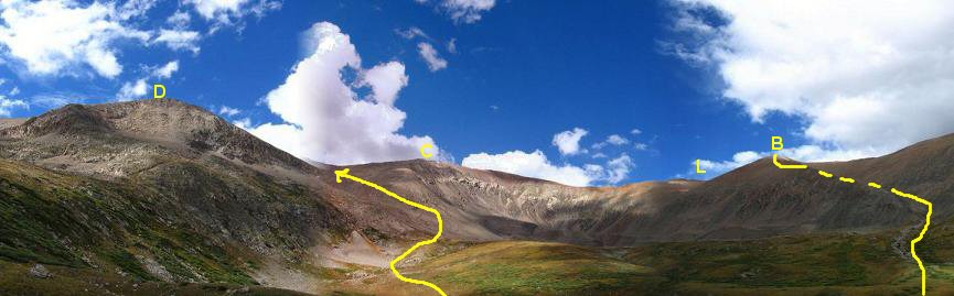
D - Mt. Democrat C - Mt. Cameron L - Mt. Lincoln B - Mt. Bross This panorama is a quite foreshortened view. The summit of Democrat isn't visible in this photo but lies a bit farther back. Mt. Lincoln isn't visible either from this panoramic view. The photos below will fill in the panorama.
Ah, now you can see, Mt. Lincoln and Mt. Cameron from the summit of Mt. Democrat. Mt. Bross is reached by heading right from Mt. Cameron.
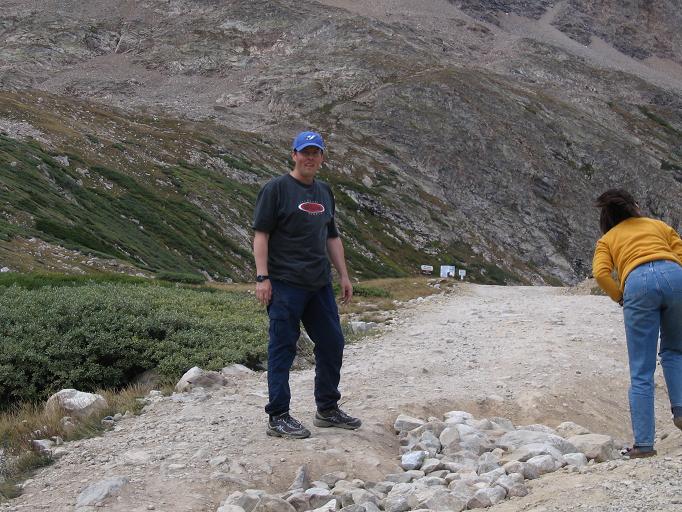
Victoria and Allan at the Mt. Democrat Mt. Cameron col
Allan descending Mt. Bross with Mt. Democrat in full view. What a good day! Mt. Democrat Mt. Cameron Mt. Lincoln and Mt. Bross Scramble: Class 1 and little bit of class 2 – Steep Hiking Altitude: Democrat 14,148 / Lincoln 14,286 / Bross 14,172 ft Elevation Gain: Up Democrat 2,150 ft / 760 ft down to Democrat Cameron saddle then up 850 ft to Mt. Cameron / then 160 ft down to the Cameron Lincoln saddle then 210 ft up to the summit of Lincoln / back to the Cameron Lincoln saddle then side trail over to the Cameron Bross saddle then 500 ft up to the summit of Bross. Total elevation gain 3,700 ft. Ascent Time: 4 – 5 hours / 7 miles round trip Highlights Kite Lake campground is at 12,000 ft and provides access to a group of three 14ers which can be done all at once with enjoyable ridge walks in between. Getting There Head west from Denver on I-70 for approx 70 miles and take exit 203/201 and head south on Colorado highway 9 through Breckenridge to Alma for about 30 miles. In the middle of Alma across from a general store you head west on the unmarked Kite Lake dirt road for 6 miles to the trailhead. The last mile of this road has some pretty rough spots especially at the end near the lake. A high clearance vehicle is necessary to make it all the way. Many park their cars down the road and walk up to the trailhead. My RAV4 and a Suburu Outback made it to within 50 yards of the trailhead. We then had to fill in a section of the road with piles of rocks to make it passable all the way so as not to risk suspension damage. Route Description From the trailhead you have a panorama of 14ers. There’s Mt. Democrat to your left, then Mt. Cameron to the right of Democrat, then far right is the tip of Mt. Lincoln, then to the immediate right of Kite Lake is Mt. Bross. The peaks are laid out like a "T" with Democrat left, Cameron at the intersection of the T, Lincoln on the right and Bross at the bottom of the T. Head out for Democrat on a good trail, you’ll see a few old mining structures up in the upper basin, the route curls around to the left, once you arrive at the top of what you could see of Democrat from Kite Lake you have to go another short distance up to the true summit. From the summit of Democrat head North down to the Democrat / Cameron saddle. Then the trail ascends 850 ft to the summit of Mt. Cameron at 14,238 ft. Straight ahead from Cameron you can see the pointy Mt. Lincoln and to your right you will see the rounded hump called Mt. Bross. From Cameron its .5 miles to Lincoln on a good trail all the way. Backtrack to the saddle between Cameron and Lincoln and take the side trail over to the Cameron Bross saddle avoiding a climb back up to the summit of Mt. Cameron. Then its 500 ft up to the summit of Mt. Bross on easy terrain. From the Bross summit rocks head basically south onto a narrow trail that skirts the right side of the southwest ridge. You should have Kite Lake to your right as you look down and a great view of Democrat. About halfway down this narrow trail you will come to a shoulder which reveals a big gully to your left. From here you have to be careful as you descend a steep scree slope down into the gully and link up with the trail on the left side. Stay on the left hillside trail of the gully all the way to the meadows near Kite Lake. Do not enter the gully as there are obstacles near the bottom. Alternatively if there is a lot of snow on the southwest ridge it would be better to head basically east until you can enter this big gully from the upper summit slopes. |