|
 Following the two days we spent at San Simeon State Beach, we drove up to Pinnacles National Monument. Following the two days we spent at San Simeon State Beach, we drove up to Pinnacles National Monument.  I had never been there which is one of the reasons why I made it a destination on this trip. Putting up the tent in the rain (rare for June) was a pain, but that's all part of camping. I had never been there which is one of the reasons why I made it a destination on this trip. Putting up the tent in the rain (rare for June) was a pain, but that's all part of camping.
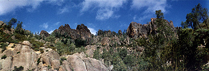
Pinnacles National Monument preserves one of the largest tracks of chaparral vegetation anywhere in California. Also there are the remnants of half an extinct volcano. The reason why there is only half a volcano is because the other half is 190  miles south in between the towns of Lancaster and Gorman. The San Andreas Fault, the major plate boundary between the Pacific Plate and the North American Plate, runs two miles to the east of Pinnacles. As the plate ground past each other, the fault literally ripped the volcano in two. The result is Pinnacles National Monument. The picture above shows the pinnacles, the volcanic rock which is left. The main feature of the park are the trails. It is a hiker's paradise. One of the trails we walked was the Condor Gulch Trail which winds its way around to the backside of the pinnacles and eventually traverses along their back. If you look closely you can see two Turkey vultures flying on the early morning thermals in the gulch. miles south in between the towns of Lancaster and Gorman. The San Andreas Fault, the major plate boundary between the Pacific Plate and the North American Plate, runs two miles to the east of Pinnacles. As the plate ground past each other, the fault literally ripped the volcano in two. The result is Pinnacles National Monument. The picture above shows the pinnacles, the volcanic rock which is left. The main feature of the park are the trails. It is a hiker's paradise. One of the trails we walked was the Condor Gulch Trail which winds its way around to the backside of the pinnacles and eventually traverses along their back. If you look closely you can see two Turkey vultures flying on the early morning thermals in the gulch.  We probably saw close to a hundred vultures in this canyon as we hiked up it. Another trail took us through some talus caves that had been eroded out by a small stream. You will need a flashlight for this trek and make sure to wear waterproof shoes or boots. There were parts of this trail where we had to wade through ankle deep water. There were plenty of frogs in these caves too. You can also take a trail over the top of the caves as well. Both trails lead up to a reservoir which is very scenic. All in all, even with the rain, it was a good trip. We ended the week with the drive further north to see the Monterey Bay Aquarium. It had new exhibits and both of the kids loved it. If you plan to go there, get advance tickets and avoid the lines. We probably saw close to a hundred vultures in this canyon as we hiked up it. Another trail took us through some talus caves that had been eroded out by a small stream. You will need a flashlight for this trek and make sure to wear waterproof shoes or boots. There were parts of this trail where we had to wade through ankle deep water. There were plenty of frogs in these caves too. You can also take a trail over the top of the caves as well. Both trails lead up to a reservoir which is very scenic. All in all, even with the rain, it was a good trip. We ended the week with the drive further north to see the Monterey Bay Aquarium. It had new exhibits and both of the kids loved it. If you plan to go there, get advance tickets and avoid the lines.
If you have any comments about this page, please sign my guestbook.
Next national park site.
Back to the National Park Page.
Information about camping here.

|
