
SCENIC QUEENSLAND
Queensland is a great place to live. It has a great climate and has over 400 National Parks to explore. Two are World Heritage Listed. National Parks are 'islands of peace' where we can get away from the rat race. This page tells more about some of my favourite National Parks that I have visited over the years. They are widely varied and divided into the following sections...
South East Queensland
The Scenic Rim
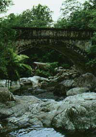
The Scenic Rim is the name given to the arc of mountains curving around Brisbane. There are about 21 National Parks in this area including Springbrook, Lamington, Mt Barney and Cunningham's Gap.- Lamington National Park
 This is one of Queenslands best known National Parks. It was declared in 1915 and covers over 20 200 hectares. It also has over 160km of walking tracks covering a variety of vegetation including: Sub-tropical rainforest, open eucalypt and Antarctic beech forests. This makes Lamington one of the most popular parks for walking (that and the 500 plus waterfalls !)
Lamingtion has camping and picnicing facilities as well as two guest houses - O'Reilly's and Binna Burra.- Mt Barney National Park
- Lamington National Park
The Glasshouse Mountains
 These Mountains are situated to the North of Brisbane, near the Sunshine Coast. They are vocanic plugs, forming a spectacular sight along the main Highway north. There are 4 main peaks which are national parks: Mt Tibrogargan, Mt Coonowrin, Mt Beerwah and Mt Ngungun.
Captain Cook discovered these mountains and wrote " These hils lay but a little way inland and not far from each other; they are very remarkable on account or their Singular form of Elivation, which very much resemble Glass Houses, which occasioned me giving them that Name."
Return to Top of Page
 Fraser Island
 Fraser Island the World's largest sand Island, 123km long and 22km wide with it's highest point about 240m above sea level, situated off the coast of Queensland east of Bundaberg. It takes it's name from James Fraser, captain of the brig STIRLING CASTLE which was wrecked in 1836. The island supports a variety of vegetation and habitats including rainforest, heathland, perched and window lakes, long beaches and coloured sand dunes. These are some of the many reasons why Fraser Island has been entered into the World Heritage List.
In my completely unbiased opinion, Fraser Island is one of the most beautiful places that ever existed ! There is just so much to see - beautiful beaches, crystal clear streams, the most amazing lakes all on the huge sand island. The only problem is that you can only see this place by air or by Four Wheel Drive vehicle. I spent a two week holiday there in 1996, and still didn't get to see enough of it !
It's hard to believe that Fraser Island was logged up until recently. There was alot of greenies protesting and eventually the logging was stopped and the whole island was turned into a National Park. Logging began on the island after the discovery of the magnificent timber by Andrew Petrie in 1863. There are a few execptions to the National Park- Kingfisher Bay Resort and a few small villages along the east coast where you can buy a few things and stay in a holiday house. There are about 100 private residences on the whole island.
 The best thing about visiting Fraser Island though is being able to camp on the beach. So many people visit to do just that, relax, do some fishing and generally get away from it all. In summer, the Island can get pretty crowded, but at your camp site, it feels like you're the only one there! There are so many interesting and spectacular areas on the island including the 42 fresh water lakes, the huge sand blows that are slowly engulfing the surrounding area and the magificent coloured sands with over 70 different colours ! There is also the annual humpback whale migration during August to October. Many whales are seen in Harvey Bay to the west of the island and that is the base for many whale watching cruises.
Fraser Island is just one of those places that you have to visit, like the Grand Canyon in the USA.. It's had to describe and the pictures hardly do it justice.
Tropical North Queensland
 There are some great National Parks in North Queensland, including Paluma Range National Park which encompasses Crystal Creek and Mt Spec, Barron Gorge National Park, Crater Lakes National Park (Lakes Barrine and Eacham) and the Daintree National Park.
Paluma Range N.P. is north west of Townsville and this is the area where my father spent his teenage years. There are some nice creeks, swimming hole and picinic areas as well as the rainforest and panoramic views further up the range.
Tropical Rainforest and waterfalls is what you will find at Barron Gorge N.P. It is situated along the Cairns to Kuranda scenic railway and Skyway. Once you're up the range at Kuranda, check out the markets !
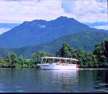 Lake Barrine and Lake Eacham make up Crater Lakes N.P. Both of the lakes have formed in extinct volcano craters.
"Where the Rainforest meets the Reef" that the best description of Daintree N.P. in far north Queensland.
Return to Top of Page
Western Queensland
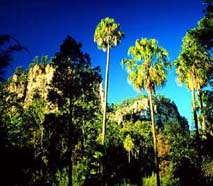 Carnarvon Gorge is an oasis in sandstone gorges.
The Simpson Desert N.P. is Queensland's largest National Park. Much of it is sand dunes and spinnifex though !


Queensland Government Travel Center
© 1998. This page is maintained by Tiny Tan. Last updated 26 April 1998.