|
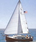
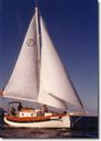
Photographs
The Com-Pac Chesapeake Bay Rally
While I was still in the process of purchasing "Solar
Wind", plans were being developed on the Com-Pac Owners Association eMail exchange
list for a Memorial Day rally on the Chesapeake Bay. Dean Shostak was organizing the
rally for twenty boats that had indicated their desire to attend. Preliminary
schedules were posted on the owner's association web site with a launch at a state park
and then a four day tour of the middle bay area. Once "Solar Wind" became a
reality, I also decided to join the rally.
While the rally was scheduled to cover about five days, I hoped
to get in more sailing time on the Bay by leaving a week earlier. This plan rapidly
turned into a disaster since the Corps of Engineers chose this opportunity to lower the
water level in Alton Pool by more than six feet below normal. This meant that there
would not be a ramp within twenty miles where I could retrieve my boat back to the
trailer. At the same time, the number of rally participants was drastically
falling. First the count went down to ten and finally, the committed count settled
at five boats with a launch scheduled for Friday at an Annapolis boat yard rather than a
state park due to some last minute changes.
While there was a hoist at the marina where "Solar
Wind" was moored, it was currently dedicated to some major repairs on a 40 foot Motor
Yacht. Therefore, plan "B" was to motor about 8 miles up river with the mast
already down and use the hoist at another marina to load the trailer. Since plan
"B" required a delay of several days to schedule hoist time, I chose this
occasion to get new bearings installed on the trailer. My scheduled departure from
St. Louis would now be such that I would arrive in Annapolis just in time for the start of
the rally. This was of course contingent on the Corps of Engineers not lowering the
river level further since the proposed hoist had just less than 3 feet of water in their
channel. Additional sailing time would then follow the completion of the rally
depending on the weather and any further surprises by the Fates or Murphy.
As the drop dead day for my departure from St. Louis neared, the
water level slowly was allowed to rise in Alton Pool. On the last possible day, I
was able to retrieve the boat at the normal ramp rather than having to motor up river and
use the hoist. This saved 3 to 4 hours of motor time and $75 in hoist fees. I
proceeded to load the car and "Solar Wind" with everything but the kitchen sink
since I really had no experience in what would really be needed.
Once on the road, I did notice that the boat appeared to sway
slightly side to side as if the bunk boards were not really providing sufficient support.
Everything appeared to be tight however so I left somewhat on schedule and
maintained a speed of between 50 and 55 depending on the road surface conditions.
The "Sail 55" course would take me across the southern
tip of Illinois and Indiania along Highway 64 and then across the northern third of
Kentucky. At Charleston West Virginia I would then turn north before crossing the
Appalician chain in Western Maryland.
Prior to the start of the trip, I had replaced a number of
screws that held the bunk boards secure with longer fasteners. The first night's stop in
Kentucky showed that this quick fix was inadaquate since all of the new screws were pulled
out. I had sufficient clearance to lash the bunk boards to the support posts and
hoped that this would do until better repairs could be instituted.
The second day's travel included the worst stretch of hills with
numerous 4 to 6 percent grades that covered from 2 to 6 miles of highway. This treck
through the hills of Western Maryland was really very interesting with lush green
forests on all of the hillsides. I did not attempt to maintain speed on these hills
- I just let the Nissan Pathfinder do it's best and stayed in the slow lane to allow the
many trucks to pass. On this schedule, the final approach to Annapolis would have occurred
late in the evening on Thursday with the rally scheduled to start with a boat launch on
Friday. Since I could not arrive early enough to launch on Thursday, I stayed
outside of the Washington area an extra night and made my way into Annapolis on Friday at
about noon.
Friday 5/22/1998
After trailering the 900 miles from St. Louis, I arrived at Sarles Boat Yard in Annapolis
to find that they were only expecting two boats rather than the original five with the
second boat due at about 2 PM. Once the boatyard owner saw my Com-Pac 19, he
became concerned about the amount of water at his ramp. He indicated that a nearby
public ramp might be a better choice if we wanted to ensure sufficient depth (it would
really depend on the tidal
conditions).
I backed my boat on it's trailer to a hillside at the edge of the boat yard , unhitched
the trailer from my Pathfinder so that I would not block the yard entrance, and began
launch preparations. I had however intended not to launch until the other boat
arrived in order to coordinate final plans. This opportunity allowed for a quick trip to a
local supply house for a few last minute parts. I did become concerned when no boats
had arrived by 6 PM and decided to go to dinner. At about 2 miles from the Marina, I
passed Dean Shostak and his wife Valerie towing their boat "Crystal Seas" into
town. I turned around and followed them back to the Marina.
Dean confirmed that all other boats had canceled so we would be free to enjoy ourselves on
a more flexible schedule. "Crystal Seas" would launch first so I resumed
preparations by mounting the gas and electric motors and started to arrange the shrouds
and stays in preparation for mast raising while Dean began his preparations. After
several minor repairs everything was ready to launch "Crystal Seas" at about 9
PM. Unfortunately, this coincided with low tide. A substantial effort by
Valerie who went swimming to pull the boat off it's trailer while Dean and I pushed from
the bow did finally succeed. After tying up "Crystal Seas" and
a break for a late dinner, the tide had turned again. Even though it was well after
midnight, efforts resumed at launching "Solar Wind".
While this should have been substantially easier, my prior unhitching of the trailer from
the tow vehicle would lead to a potential disaster. With the motors mounted and much
of the interior boat contents unloaded, I climbed into the cockpit and leaned over the
stern rail to thread the halyards at the mast head. The boat promptly rotated on
it's single axle trailer and pointed the bow up to about a 30 degree angle. Only the
extended rudder resting against a pile of lumber on the hillside prevented a real
catastrophe.. All of my preparations had reduced the tongue weight to less
than 10 pounds so that my movement had made the boat stern heavy on it's trailer.
Fortunately, the combination of the hillside and the extended rudder prevented any serious
damage (except to my ego).
Since I intended to raise the mast on the water after launching,
I immediately hooked my Pathfinder up to the trailer and towed it to a more level site.
Dean, Valerie, and I continued with a few more preparations and then launched
without further incident. By 2 AM, both boats were in the water and tied up at their
assigned slips for a well deserved good nights
sleep.
Saturday 5/23/1998
The following morning brought cloudy skies and pleasant temperatures. With
assistance from Dean and Valerie, the mast on "Solar Wind" was raised while tied
up at it's slip without further incident. By 2 PM, the skies had cleared and we were
joined by Scott and Diane who would complete the crew of "Crystal Seas" for the
next few days.
For our first cruise, we departed the Marina in time for the 2:30 PM bridge opening on Spa
Creek. The remainder of the afternoon was be spent on a shakedown in the mouth of
the Severn River. In all of the boat traffic, we quickly became separated so I
motored up wind to a location opposite the furthermost radio tower at the mouth of
the Severn. I then turned and
sailed peacefully up the Severn under Jib alone for a total of two nautical miles.
This course includes a trip past the entrance to Annapolis Harbor and the
United States Naval Academy grounds. At the first Bridge over the Severn, I turned
around and motored back to Annapolis Harbor in time for the 5 PM bridge opening where I
meet up with Dean and his crew again. The evening consisted of further preparations
for the next day's crossing of the Bay.
The apparent lack of training most people have in marine VHF radio procedures was very
evident during this first trip. The calling channel was routinely cluttered with
requests for radio checks, spurious responses to radio checks (such as a claimed response
from Bermuda), and long drawn out conversations that would not move to working channels.
Sunday 5/24/1998
We departed from Spa Creek at the 8:30 AM bridge opening and assumed a course for the
mouth of the Severn River. Winds were non-existent and there were bright sunny
skies. The course had to be altered to avoid a number of crab pot lines set near the
Harbor entrance but once out on the Bay, we turned northeast and made for the center span
of the Bay Bridge (a distance of about 3.5 nautical miles). Passing inside the
western leg of the center span, we allowed sufficient room for a passing towed barge at
the eastern leg. This is not too difficult since this section of the bridge has a
horizontal clearance of 1,500 feet with a vertical clearance of 186 feet. Once the traffic
had cleared, we crossed the ship channel and assumed a course for the marker hat
indicated the shoal at Love Point on the northern tip of Kent Island (a distance of
another 5 nautical miles).
Since I knew my estimated fuel consumption from prior testing, I
established a pattern of stopping at idle speed every hour to refill the outboard's 1/2
galon tank. This procedure did confuse Dean somewhat till he realized that I did not
have a remote tank fuel option on my 4 horsepower outboard. I did not feel this to
be a necessity at the time I purchased the motor - anyway, it can still be added at a
later date if my thoughts change. It was convenient to add fuel every hour to better
monitor consumption rates since I still had litle experience with this aspect. Since
I need to mix gasoline and oil for my two-stroke motor, I do carry two tanks of
2 1/4 gallons each so that with the internal tank, I have a total
capacity of almost five gallons. This is sufficient for almost 10 hours at 2/3
throttle. I feel that the two tank arrangement also makes it easier to mix the
gasoline and oil.
Rounding Love Point, we assumed a southeasterly course for 5
nautical miles of motor sailing in Strongs Bay at the mouth of the Chester River.
This brought us to the entrance of the new Kent Island Narrows channel.
The new channel was not indicated on my charts since they were several years old.
Dean was familiar with the entrance and since there was a great deal of
other boat traffic, we could just follow the crowd to the bridge.
The Bascule Bridge at Kent Narrows is slightly larger than the one we had negotiated
before at Spa Creek in Annapolis with a horizontal clearance of 48 feet and a vertical
clearance of 18 feet. This bridge also opens every 30 minutes but the tidal currents
can be very severe so priority went to the boats traveling with the current. Since
the tide was still rising, we
waited till the northbound boats had transited the bridge and then moved south against a
current of several knots through the channel.
The night was spent tied up in a slip at Scott Marine.
This boat yard is just south of the Kent Narrows Bridge and just off the
channel that leads out to Prospect Bay. Like all of the slips we visited, this
marina was set up for boats of about 40 feet and my 15 foot dock lines proved to be almost
useless. While I had 100 feet of 3/8 inch three strand nylon on board to
prepare new lines, Dean had several longer dock lines available and graciously allowed me
to use them instead.
With the excellent dockside restaurants available, we all walked to Harris's Crab House
and enjoyed a few cold ones along with some excellent seafood. During the night, a warm
front passed through the area and a southerly breeze built at 10 to 15 knots. Since
the marina was exposed to the south, this meant a night of significant rocking action
accompanied by the sounds of a band at a nearby open air restaurant - neither was enough
to disturb my sleep.
Monday 5/25/1998
Departure from Scott Marine was tricky for me with a strong breeze blowing from the south.
In order to retrieve the dock lines and still exit the Marina without damage to my
boat as well as others, Dean boarded "Solar Wind", collected lines, and fended
off with the boat hook while I tried to keep the boat moving somewhat in the desired
direction. At this I failed and ended up exiting the Marina channel in reverse.
Dean then jumped off at the last slip and brought "Crystal Seas" out to
the channel to meet me.
Once out in the main channel, we motored south through Prospect
Bay into a rising tidal current and 10 to 15 knot head winds that had created 1 to 3 foot
swells. At this point, the difference between the hull configuration of the Com-Pac
23 and the Com-Pac 19 was most evident since "Crystal Seas" would climb the
swell and then appear to slice into the next wave while "Solar Wind" would climb
the swell and then it's flatter hull would pound down on the next wave with a significant
jolt. Since I had retained a cooler of soda cans in the cockpit, this proved to be
another hard lesson. With each jolt, the cooler had a tendency to travel so I would
need to pin it in position with my legs to avoid an accident.
These conditions continued for the first three nautical miles of
the trip through Prospect Bay. I was continuously envious of the stream of 35 to 45
foot boats that could be seen at the horizon on their northbound route out of St.
Michaels. These boats had the best of conditions with a broad reach under full sail.
One boat even had a cruising spinnaker set.
Once we got south of Tilghman point, we entered the mouth of the Miles River and
conditions flattened nicely. We followed the channel east of a shoal and then raised
sail for about an hour in the quiet breezes outside of St. Michaels around Leeds Creek.
Since most boats had already left the area on their return north to Annapolis and
Baltimore, we had this area of about two square miles to ourselves.
During this point in our excursion, I did have time to observe
the harbor approaches and saw power boats moving at full tilt right up to the final
inbound marker where the channel turned 90 degrees to starboard. At this hard turn,
a personal watercraft had taken station and would attempt to jump the wakes of each
inbound craft. This seemed to be one of the most dangerous activities possible.
We then entered the harbor for a nights mooring at the St.
Michaels Town Marina. The entrance to St. Michaels is well marked and the route to
the town docks passes the Marine Museum and it's reconstructed lighthouse to starboard. At
the docks we were met by a dock hand (Nate) who had us positioned in the slips in no time
flat. His instructions about line length and slack to leave were precise - and while
this was on a rising tide, I only needed to slack one line by about 6 inches at the low
tide point several hours later. Nate's 17 years of experience really showed.
Our arrival at about 2 PM left sufficient time for a refreshing swim in the dock side pool
and then a stroll through the shops of the St. Michaels downtown area before dinner at the
Crab Claw restaurant. The dockside seating under an covered porch provided a
pleasant environment to enjoy more of the area's excellent seafood. Those
unfamiliar with the area
should note that a number of establishments (including the Crab Claw) do NOT accept credit
cards so you should carry sufficient cash (there are reported to be two ATM machines in
the downtown area).
Tuesday 5/26/1998
During the night, the winds shifted again as a weak cold front passed the area. The
morning's conditions were clear sky and a report of 10 to 15 knot winds from the
Northwest. Our departure at about 8:30 for Annapolis would once again be mostly into
these headwinds.
The selected route to Annapolis from St. Michaels led north for about 5 nautical miles and
then turned southwest at Tilghman Point into the shelter of Eastern Bay for about another
seven miles. With this heading, we were able to raise sail for almost two
hours with excellent conditions. However, as we approached the required northwesterly turn
at Bloody Point at the
extreme southern tip of Kent Island, conditions deteriorated. With our new
northwesterly course we once again had to motor into 1 to 3 foot swells with the 10 to 15
knot headwinds. These conditions remained constant for the remainder of the crossing
of the Bay until we finally approached the western shore near the famous Thomas Point
lighthouse (a total of about seven nautical miles).
From Thomas Point lighthouse, we continued into headwinds for the remainder of the trip to
Annapolis arriving at the Spa Creek bridge in time for the 3 PM opening. The 24
nautical mile trip from St. Michaels to Annapolis required a total of about 6 hours and my
4 horsepower motor consumed about 2.5 gallons of fuel.
Since I intended to depart early the following morning, Dean and Valerie assisted me with
lowering the mast while still on the water. We then celebrated a successful cruise
that evening at Pusser's restaurant in Annapolis limiting our beverages to iced tea rather
than the more famous "Pain Killers".
The Return Home
Prior to re-loading the Solar Wind to it's trailer, I marked the
current position of the support posts and then raised all supports by 1/2 inch to provide
better stability for the return trip. I also moved some un-needed equipment to the
v-berth area in order to all some additional weight forward for the trip. These
precautions appeared to help since I did not notice the amount of sway in the boat evident
in the trip to Annapolis.
I was able to "Sail 55" or the return trip along the
same route with only an overnight stop required outside of Charleston West Virginia;.
returning to St. Louis on Thursday evening. During the last 100 miles a
persistent rattle developed that I could not pin-point until I arrived home and found a
broken support bracket on one of the fenders.
Lessons Learned
1) Never work on the boat while it is on the trailer without
placing a support jack under the frame behind the axle.
2) Have the most current charts available.
3) Have more - and longer - dock lines made up in advance
4) No loose gear in the cockpit or anywhere else for that matter.
Points to Consider for Future Trips
1) I had suspected the trailer to be under designed for really
heavy duty use - this proved correct so I will consider replacement of the trailer
2) Pack Less - I had everything but the kitchen sink packed - I'll take less on
future trips
3) Organize the boat better - with all of the things I had packed, the one item
that I needed would always be behind or underneath two other extraneous items.
4) No loose gear - establish a check list for leaving harbor
This page was last updated: 01/19/01 08:39:00 AM
|  The Comfortable Pocket Yacht