|
Number of routes About 50.
Climbing style
Guidebook
How to get there [click for map]
Turn right down the road and drive for 16 km (from the Gordon Road) until a large boulder sticks out on the right, nearly overhanging the road (this is the climb Roadkill!). A top-rope problem also exists on this boulder and is about grade 17. Only 50 metres on from this it is possible to park on the left, opposite a slimy looking bank. Walk up this bank with a little difficulty, then head up to the right through bracken and bushes for about 100 metres to the large boulder. This boulder is known as The High Wire. Follow the blue tapes up the hill to the top of the hill to find Pyramid Rock and the Bear Pit, follow the orange tapes to the Trapeze.
Associated links and references
|
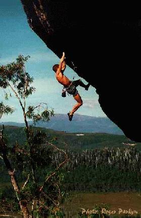 Above: Sam Edwards working Forearm Flameout (27). Photo: Roger Parkyn |
Bare Rock (Fingal)
Climbing style
Guidebook
How to get there [click for map]
Directly behind Fingal, in the Fingal valley about an hour from Launceston. These next directions directly from Craglets. Take the first R-hand turn (Legge St) upon entering the town and drive south towards the highly-visible cliff past several intersections until the road curves R and then back L. Continue straight ahead along a track to a locked gate (2.2km from main road) with "Tresspassers Prosecuted" sign. Continue through gate following the track wich turns sharply L, descends past an old wooden shed, then gains an old rocky road leading up a small hill to another gate, giving access to a paddock. Cross the paddock to a gate. Trend L up hill to the rough road just over its crest which leads to within 100m of the cliff.
Associated links and references
Number of routes
Under 20 routes on a huge dolerite face.
The rock is dolerite and towers to 200m in height. However, it's not regular Tasmanian dolerite in the sense that it isn't regularly columnar and so there isn't an overabundance of "straight-up" cracks. The climbing is serious due to the patches of loose rock (wear helmets) but there are some absolute stunning bolted, slabby multipitches, such as The Sapphire Rose (22) which are a must if visiting this crag.
• Craglets 4th edition has a good section on Fingal.
First you must check with the owners, Trevor and Sue Berryman to obtain permission (they live at Fingal and can be contacted on 03 6374 1002). The cliff is usually closed for a period in Spring for falcon nesting.
• Craglets (4th edition) paper guide
• Nermut's overview and a pic
 Above: Defender Of The Faith (21), Robin's Buttress. Photo: Simon Carter |
Number of routes A few hundred routes over many different areas.
Climbing style
Guidebook
How to get there [click for map]
Associated links and references |
Cataract Gorge (Launceston)
Climbing style
Guidebook
How to get there [click for map]
Number of routes
A few hundred over dozens of buttresses.
Short dolerite buttresses with climbs ascending cracks and corners with natural protection. Modern routes have branched out onto aretes with bolt protection. There are two main areas of the Gorge: the Sunny Side and the Shady Side.
• "Craglets" (4th edition) paper guide has an interim guide to the Gorge.
• Craglets Gorge Update with new routes and corrections to the paper guide.
• Nermut has done an
online mini-guide to the Gorge with good topos.
One of the best things about the Gorge is the access. Simply drive down Paterson Street and park five minutes from the centre of Launceston in the Penny Royal car park. From there, walk to the closest side of Kings Bridge and up the Zig Zag track. Within a few minutes you should start passing the buttresses. Most of the climbing is on the down side of the track - there are eroded foot pads to most of the more popular areas. To get to Duck Reach get hold of a tourist map and follow it to the old Duck Reach power station. Walk down to the river and upstream to the buttresses. For Riverbend, drive out through St. Leonards to Corra Linn. A couple of hundred metres past the bridge is a gate on the left hand side of the road. Walk from here across the paddocks for around 10 minutes to reach the crags above the river. Thanks to Nermut for access info.
Associated links and references
• Craglets (4th edition) paper guide
• Craglets Gorge Update
• Nermut's overview and photos
•
Nermut's online mini-guide with topos
Associated links and references
• Craglets (4th edition) paper guide
|
Number of routes Unknown.
Climbing style
Guidebook
How to get there [click for map]
Associated links and references |
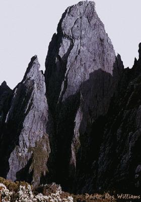 Above: The NW face of Federation Peak. Photo: Reg Williams. |
Fortescue Bay (Tasman Peninsular)
 Above: Stefan Eberhard on Ancient Astronaut (24), The Moai, Fortescue Bay. Photo: Roger Parkyn |
Number of routes A couple of routes on each of three, free-standing coastal spires, and numerous routes on surrounding coastal cliffs.
Climbing style
Guidebook
How to get there [click for map]
Associated links and references |
Frenchmans Cap
Climbing style
Guidebook
How to get there [click for map]
Associated links and references
Number of routes
Up to 100 routes scattered across the mountain.
An alpine feel. Probably the most popular large wall climbing in Tasmania, but still sees very few visitors. The rock is spectacular white quartzite which is compact and solid for the most part, and routes can be quite run-out because of this. Fixed protection is very rare, although you might find some fixed pitons and the odd bolt.
• Frenchmans Cap, Stephen Bunton, included with the Jan-Jul 1990 Rock magazine. The guide can be obtained online at Nermut's site
• Here is an excellent topo
Thanks to Nermut for this info. Two to three hours drive from Hobart along the Lyell Highway there is a signposted carpark where the walking track to Frenchman's Cap starts. From here it is a full day's walk (25km) to Tahune Hut, where most climbers camp. From the hut it is a relatively short walk to the base of the mountain. See the Notesheet for Frenchmans Cap Track for more information.
• Online guide
• Nermut's overview and pics
• Craglets slide show
• Notesheet for Frenchmans Cap Track
|
Number of routes Hundreds of routes over many different large coastal crags.
Climbing style
Guidebook
How to get there [click for map]
Associated links and references |
 Above: Jay Audenart on Nunc Dimitis (26), The Underworld, Coles Bay, Freycinet. Photo: Michael Myres |
Continue to Tasmania 2