Freuhauf
Climbing style
Guidebook
How to get there
Associated links and references
Geryon & The Acropolis
Climbing style
Guidebook
How to get there [click for map]
There are bus services to Derwent Bridge and Lake St Clair from both Hobart and Launceston. There is a 5 5 km walk from DB to
Cynthia Bay at the S end of Lake St Clair. A power boat can be booked at the kiosk to avoid the long walk to Narcissus Hut at the head of the lake. The walk from Narcissus Hut to Pine Valley Hut is along easy tracks (choice of two) and lakes about three hours. Transport may be seasonal - check in advance.
Associated links and references
Number of routes
About 20.
Sandstone climbing around 15m in height. Mostly top-rope training routes in the very urban setting of Hobart. Grades range from 17-27 with most routes around the 24-26 mark. Many routes are chipped, retrobolts have been added to routes and top rope anchors abound - an ethical nightmare! One of the 'classics' of the crag is called Suck Ethics (25).
• Craglets (4th edition) paper guide
This from Craglets. Drive up Davey St to the Southern Outlet. Turn R down Macquarie St and follow this to bus stop 16. Take the R turn into McRobbies Gully Rd (towards the tip), then R again into Degraves St. Go across the bridge then turn L into Tara St. Park outside Freuhauf gates as they are closed after hours. The cliff is obvious, a couple of minutes away.
• Craglets (4th edition) paper guide
Number of routes
40 or more.
Big. Many routes over 300m high with the classic, seven-pitch North to South Traverse (17) a must! The East face of Mt Geryon towers an impressive 500m in height. Prepare for wild climbing! The main attractions are magnificent climbing on sound dolerite (with excellent friction and protection) in a spectacular mountain setting. Almost unlimited virgin rock, long routes and relatively good weather and access are others. Summer is the rockclimbing season with February and March having the best weather.
• Mt Geryon and the Acropolis, Rock magazine 1984. You can get the original guide by paying Rock $7 for a 6 page
photocopy. However, the guide is now online on Nermut's site
• Craglets (4th edition) paper guide
This from the original guide. Access is by Lake St Clair and Pine Valley Hut. Five km up Cephissus Creek from the hut is the sheltered Geryon Campsite (signposted from the hut). From here a short, rough track, marked with tape, heads NE to the foot of a remarkable scree chute which leads up and R to the foot of the W face of the South Peak of Mt Geryon. From here rough tracks go N and S below the cliffs. The former goes past the Foresight, to the summit of Geryon's North (highest) Peak. The latter, with a low variation, leads to the Acropolis-Geryon saddle, an inspiring face.
• Craglets (4th edition) paper guide
• Nermut's full online guide
• Nermut's overview and pics
• Craglets Geryon update
|
Number of routes Under 40.
Climbing style
Guidebook
How to get there [click for map]
Associated links and references |
 Above: Unknown climber on MDMA (27). Photo: Climbers Club of Tasmania |
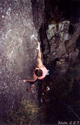
 Above: The Rock Police (24), Gunners Quoin. Photo: CCT |
Number of routes 50-60.
Climbing style
Guidebook
How to get there [click for map]
Associated links and references |
Kempton Quoin
Climbing style
Guidebook
How to get there [click for map]
Associated links and references
Number of routes
20-30.
One of the most impressive chunks of dolerite in southern Tassie which is up to 70m high in places. Still very undeveloped, but lots of classics are already established.
• Craglets (4th edition) paper guide
Located up in the hills to the East of Kempton in southern Tasmania. It is about 45 minutes drive from Hobart but you have to go by a round about route. The walk from the car is only about 5 minutes. This info from Craglets. From Hobart, drive to Colebrook (via Richmond and Campania). At Colebrook, turn L onto Yarlington Rd, cross the rail line and continue up the dirt road. Turn L at a fork in the road at 9.5km from Colebrook (don't get sucked into taking the turn about 1km before it, where there is a green building in the trees). Drive up for another 1.2km until a yellow steel gate blocks the way. Walk along the road from here. Don't head towards the cliff too early, but walk for about 300m to a point where the road goes downhill a bit. Start walking towards the cliff at the point where the road begins to descend.
• Craglets (4th edition) paper guide
• Nermut's brief overview
|
Number of routes Somewhere around 100?
Climbing style
Guidebook
How to get there [click for map]
Associated links and references |
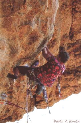 Above: Mike Law at grips with Diana Palmer (26). Photo: Venus Kondos |
Larks Edge
Climbing style
Guidebook
How to get there
Associated links and references
Number of routes
About 30.
Although this seaside crag is small, it has some worthwhile little climbs and is only about 30 mins south east of Hobart. Once again, expect short dolerite buttresses.
• Craglets (4th edition) paper guide
This info from Craglets which also has an excellent map. A 30 minute drive and a slightly shorter walk. Leave Hobart and drive toward Clifton Beach. About 100m before the beach (and just before the wooden bus shelter) turn L down Bicheno Rd. Now down the road to a R turn at the "Clifton Beach Coastal Reserve" sign, about a kilometre past the last hump. Drive along the gravel road for several kms until almost at the Cape. Park in the lower car park and walk through the trees and across the paddocks towards the coast. Follow the coast north for about 1.5km. After passing an inlet, you will glimse the cliffs in the distance. When amongst the old grey stumps drop downhill to Lark's Edge.
• Craglets (4th edition) paper guide
• Nermut's brief overview
 Above: Jonothan Nermut on The Etiquette Of Violence (22), Mad Monkey Crag. Photo: Unknown. Jonothan Nermut Collection |
Number of routes About 10.
Climbing style
Guidebook
How to get there
Associated links and references |
Continue to Tasmania 3