 Editorial
Start page
Editorial
Start page
From La Mucuy to Laguna de la Coromoto
Introduction
Level: V-
Where is it: At "Sierra Nevada de Mérida" National Park, Mérida State, Venezuela. It is necessary to get first to Tabay town, about 12 km (7.5 miles) from Mérida city in the Transandina road, and then take the road to "Area Recreativa La Mucuy Alta" (add other 8 km - 5 miles). There is where trail starts, and you have to walk another 9 km (5.6 miles) to get to Laguna (lagoon) de La Coromoto.
La Mucuy represents an strategic point, allowing access to a lot of interesting places inside Sierra Nevada. Among them: Laguna de la Coromoto, Laguna Verde, Laguna del Suero, Humbolt & Bonplandt peeks, Travesía and La Concha peek. Also, it is possible to have access to Páramo La Victoria and from there to Laguna del Santo Cristo and the area surrounding Mucuchíes.
Additionally, southwest of Tabay and near La Mucuy there is a hamlet called Mucunután, and from there you get access to Bolívar, Espejo, El Toro and El León peeks, and famous Los Nevados town.
Description: This trip requires physical fitness, because it is a very long road with step areas. Backpacks go very heavy because there is NO logistic support after leaving La Mucuy, so you have to carry all gear and food you're going to need.
On top of that, "Mal de Páramo" (highness sickness) starts to attack some people a little before getting to Laguna de La Coromoto, located at 3300 m (10820 ft) above sea level. Average temperature during day is 14°C (57°F), so you have to carry appropriate clothes, and pack them in such a way that in case of rain they keep dry (and it rains very often!).
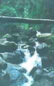
Most part of this trail goes through a thick rain forest, getting thinner as you gain altitude. You have to cross several ravines, some of them dangerous during wet season, so be careful. When you're getting to lagoon, the forest is replaced by bamboo and bushes (max. 4 m - 13 ft - high). Almost all this track goes in a deep and narrow gorge, so visibility is limited.
Nevertheless, when you get to lagoon, the gorge is replaced by a series of valleys of glacier origins, and vegetation is typical from these moors: Frailejones, coloraditos and small bushes. Landscape is spectacular and vary different to any other in Venezuela.
How to get there: First, you have to get to Mérida city (located west of Venezuela, in the Andes) by plane or bus. From east of country, buses come by the road at south of Maracaibo Lake and when they reach El Vigía city turn south and get into Los Andes.
On the other hand, if you come from west you'll get to Mérida passing through Bailadores and Tovar towns. Anyway, no matter how you get to Mérida, you have to continue northeast using Trasandina road (heading to Mucuchíes and Apartaderos) until you get to Tabay. Please take note that if you have your own automobile, you can also get to Tabay coming from Valera or Barinas, using the Trasandina in opposite direction.
In Tabay, you'll hire a jeep that will take you to Area Recreativa de La Mucuy Alta, where you'll find the ranger station and the start of trail.
Time: From La Mucuy to Laguna de La Coromoto you'll spend 6 hours if you carry all your camping gear. I recommend you to stay there a full day to enjoy the surroundings, and get down the third day (you'll spend about 4 hours going down), totaling 2 and a half days. Add another 2 days to get to Mérida.
It is very, very important to take note that in La Mucuy you'll find several boards showing very low climbing times. Don't pay attention to them. Those times are calculated without gear and for individuals with excellent (and enviable) physical conditions.
|
Top of this page
|
Sign Guestbook!
|
Guestbook!
|