|
|
Twister |

|
Storms and Cyclones of the Pacific Northwest In the fall and winter months we are vulnerable to the effects of severe winter weather such as wind, snow, heavy rain, and extreme cold and flooding. Our water is too cold for hurricanes but we do get damaging, destructive windstorms, these are known as cyclones and these storms cause millions of dollars of damage and leave thousands without power. Here are some of the destructive, powerful windstorms that have struck the Pacific Northwest over the years. The Big Blow of Columbus Day October 12th, 1962:
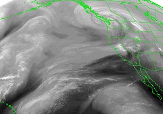
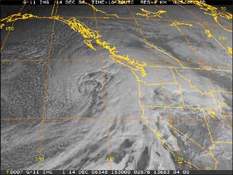
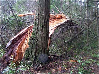
This is the most destructive windstorm in West Coast History and it remains the mother of all windstorms. This storm was originally a strong cold front; it merged with dying Pacific Typhoon Freda to become an intense mid-latitude cyclone, which slammed the California Region first and then slammed Washington and Oregon. South winds reached 85 mph in the California Region, with gusts to 135 mph. South winds reached 78 mph in Washington, Oregon and British Columbia, with gusts over 100 mph. Along the Washington, Oregon, California and British Columbia Coasts south winds reached 119 mph, with gusts to 130 mph. Millions were left without power as trees blew onto power lines and plunged millions of residents in each region into darkness along the West Coast. The storm blew down more than 100 board feet of timber in what remains to this day to be the most destructive windstorm in West Coast history. Damage cost was over 10 million and 46 deaths were reported. This is no real radar image of this storm, but you will see other radar images from a few of the other cyclones. Besides a few radar images and at least three diagrams you will also see storm damage photos from a few of the cyclones.
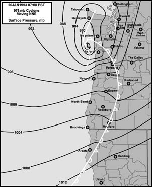
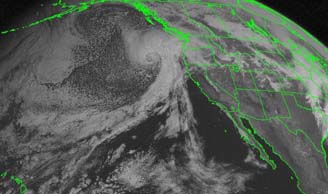
The Destructive Inauguration Day Storm of 1993:
A 976 millibar cyclone moved northeast along Washington Coast and it came ashore at Northern Whidbey Island, generating an extremely destructive northerly gale across Washington and Oregon. North winds reached 74 mph in Washington and Oregon, with gusts of 80 to 90 mph. Winds gusted to 88 mph in the Central Puget Sound Area. In Bellingham, winds gusted to 90 mph. In Oregon, winds gusted to 87 mph. This destructive northerly gale blew trees and power lines down like dominoes. The trees were not prepared for the northerly onslaught because they are adapted for high winds from the south because that's the way our storm winds and regular prevailing winds blow. Along the Washington and Oregon Coasts, north winds reached 120 mph, with gusts to 150 mph.
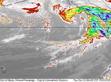
The Destructive Cyclone of December 12th, 1995: This storm was another "Cyclogenic Bomb" an explosively developing cyclone that "bombed". This dangerous cyclone had a central low-pressure of 953 millibars by the time the south winds began to increase in Washington and Oregon. First this deadly cyclone slammed the California Region; south winds reached 74 mph, with gusts of 100 to 135 mph. Then it moved north into Washington and Oregon in the evening and the south winds began to increase. South winds reached 60 to 66 mph in Washington and Oregon, with gusts over 70 mph.
The winds during this event almost matched the major Inauguration Day Storm of January 20th, 1993, but nevertheless; this was a major cyclone and damage cost from the destructive south winds was several million. The Major Windstorm of November 23rd and 24th, 1998: A very deep low came roaring in from the coast, its center making landfall on Tatoosh Island. This intense cyclone brought the most widespread wind event in many years to Washington and Oregon. South winds reached 60 mph with gusts to 73 mph in Washington and Oregon.
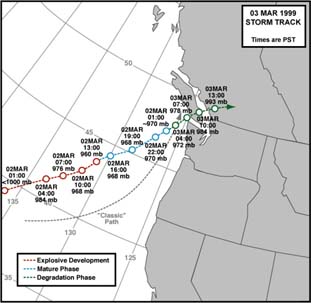
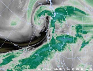
The Major Windstorm of March 3rd, 1999:
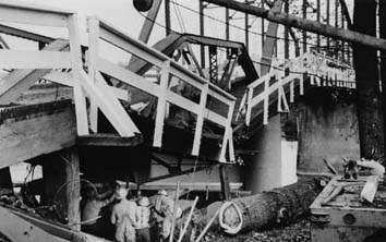
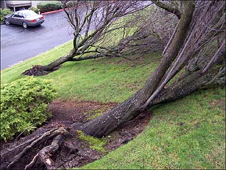
A mature, intense 960 millibar cyclone roared up the Pacific Coast and into Vancouver, the center making landfall on Tatoosh Island. This kicked up the most intense region-wide windstorm since the Destructive Cyclone of December 12th, 1995. South winds reached 63 mph in Washington and Oregon, with gusts of over 70 mph. In the Central Puget Sound Region wind gusts peaked at 71 mph. In Bellingham, wind gusts peaked at 73 mph. The 520 Bridge in Washington was destroyed during the storm. Thousands were left without power as trees blew onto power lines. Transformers also blew out. One woman was killed by a falling tree. Along the Washington and Oregon Coasts, south winds reached 100 mph, with gusts up to 120 mph. Power restoration took several days or more and damage cost was several million.
The Strong Windstorm of January 16th, 2000: A very deep cyclone moved in from the coast, bringing one of the strongest gales of the 1999-2000 Winter Season to Washington and Oregon. South winds reached 55 mph in Washington and Oregon, with gusts of 60 to 70 mph. This cyclone didn't make landfall directly on Tatoosh Island, therefore the winds were a tiny bit weaker than some of the other storms. Nevertheless this still remains one of the top windstorms in Pacific Northwest History. Had the cyclone been just a little deeper and if had made landfall directly on Tatoosh Island, the winds might have been comparable to the major Cyclone of December 12th, 1995 or the major Cyclone of March 3rd, 1999. But, even though this cyclone didn't make landfall directly on Tatoosh Island, the strong winds still packed quite a punch and damage cost was about a million.
A very strong 968 millibar cyclone roared in from the coast and made landfall on Tatoosh Island. This kicked up the most destructive windstorm since the major Cyclone of March 3rd, 1999. South winds reached 66 mph in Washington and Oregon with gusts to 78 mph. All of the Floating Bridges were closed during the storm. Along the Oregon and Washington Coasts, south winds reached 100 mph, with gusts to 129 mph. 140,000 people lost power as trees were blown onto power lines. South winds reached 100 mph on the Washington and Oregon Coasts, with gusts to 120 mph. Total damage coast from this storm was estimated at several million and it was most destructive windstorm storm in seven years. The damaging south winds also blew out transformers and substations in Washington and Oregon. Power restoration took about a week. New additions will be added to this as we have more cyclones.
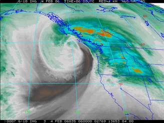
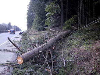
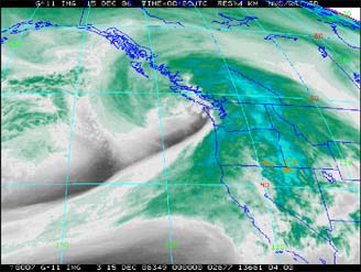
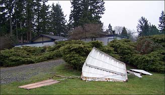
The Hanukkah Eve Windstorm of December 14-15, 2006 An intense, tightly wound 970 millibar cyclone roared in from the Pacific Ocean, its center making landfall on Southern Vancouver Island, kicking up one of the most destructive windstorms since the devastating Inaugural Day Storm of January 20th, 1993. But this time the winds came from the south, not the north. South winds reached 76 mph, with gusts of 85 to 95 mph across Washington and Oregon. Along the Washington and Oregon coasts, south winds reached 90 mph, with gusts to 120 to 130 mph. Total losses from the storm were extreme. The hurricane winds also blew roofs off around the Pacific Northwest. Some homes were severely damaged and some were destroyed. High voltage transmission lines, regular power lines and trees were toppled, leaving 1,000,000+ people in Washington and Oregon without power. Transformers also blew out and several major substations lost power. Heavy rains also accompanied the storm and one woman drowned in her basement as flood waters enveloped her. About 4 deaths were reported during the storm from trees smashing onto houses or cars and trucks, the drowning woman in her basement was the fourth death. The Seattle Times lost power for the first time in many years during the storm. Power restoration took about 10 days.
|