Caddo River

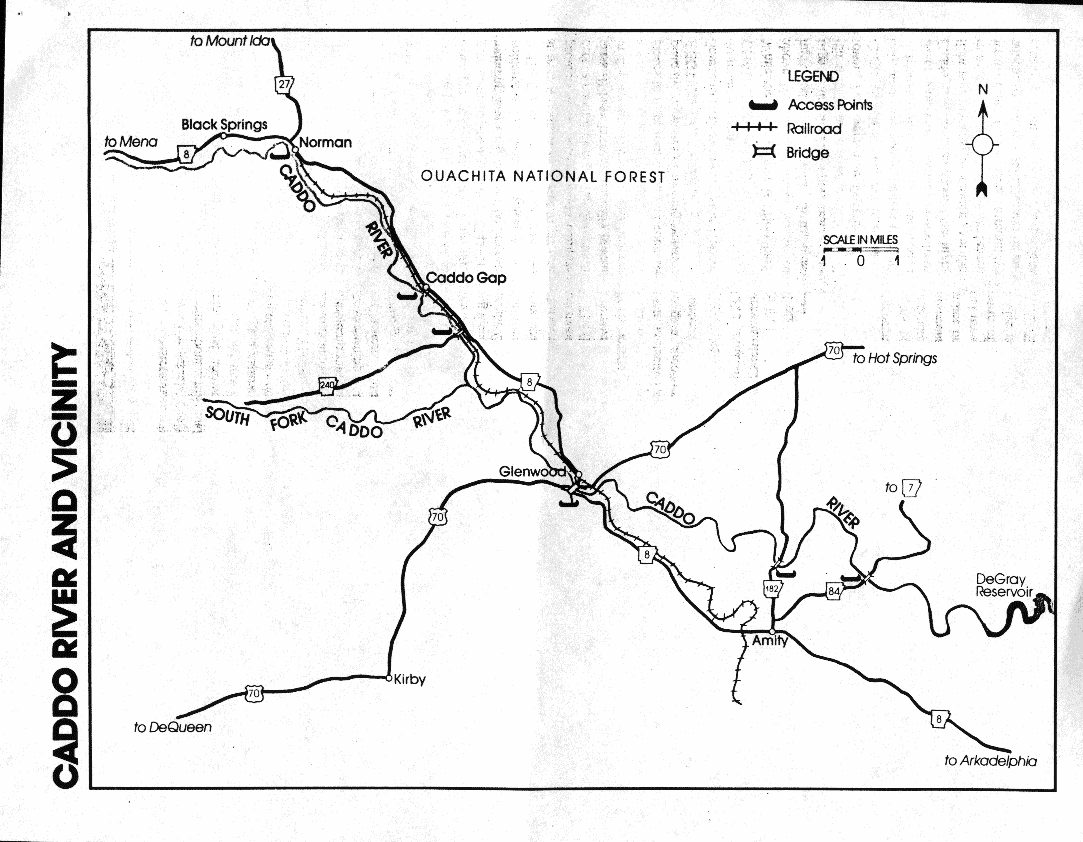
Caddo River map
Flowing out of the Ouachita Mountains in west central Arkansas is one of the state's most unappreciated streams
-the Caddo River. Those that know it,
however, describe the Caddo as among
the best "family outing" type streams
in the state.
It begins in southwestern Montgomery County, and flows near or through the communities of Black Springs,
Norman, Caddo Gap, Glenwood, and
Amity before entering the backwaters
of DeGray Lake. In fact, throughout
this 40-mile journey, the Caddo is
never very far from civilization. Railroad tracks parallel the stream for several miles, a few houses can be spotted
from the river, and cattle frequently
gaze down at passing floaters. This surrounding landscape may not be original wilderness, but it sure is peaceful.
The Caddo itself is also peaceful -
at least in most places. But to prevent
paddlers from becoming too complacent, a handful of faster rapids (class I/
class II) have been strategically placed
in the stream. The river also features
some top-notch gravel bars, ideal
places to stop, lean back, and contemplate the mysteries of moving water.
SECTION DESCRIBED
Source to DeGray Lake, a stretch about
40 miles in length.
Characteristics
While the Caddo River is "floatable"
above Norman (the water has to be
high, and it's a very fast float), most
trips on the stream's upper reaches begin at the southwest edge of this small
town. The eight-mile float down to
Caddo Gap is scenic, but is possible
only after extended periods of rainfall.
Probably the most popular Caddo
River float is the six-mile journey from
Caddo Gap to Glenwood. One highlight is a swinging footbridge over the
river at the put-in (the low-water bridge
west of the Caddo Gap community)
which, for safety's sake, should be appreciated from below. Rock gardens
are common along this stretch and can
cause consternation when the water's
low. The actual ''gap" for the Caddo
occurs about a mile and a half into the
trip (just above the Arkansas 240
bridge). At this point the river passes
through a narrow opening between the
ridges, and so do Arkansas 8 and the
railroad - all three bunched closely together. The gap is also the site of a
geological oddity: some hot springs
bubble up into the stream bed here (for
those wishing to experience these thermal waters, here are some rough directions: go upstream 200-300 yards from
the old low-water bridge; springs will
be on the west bank, and are usually at
or below the river's surface; barefoot
waders will have no trouble recogniz-
ing the spot!). Two and a half miles later, the Caddo's South Fork enters from
the west. Small rapids, long gravel
bars, and an occasional willow thicket
characterize the stream as it approaches
Glenwood.
The float from Glenwood to Amity is
a slower version of the upper sections.
Pools are longer, and the rapids lose
some of their intensity. Yet it's a fine
float, perfectly suited for those wishing
to gain encouraging experience in a
canoe.
SEASONS
Like most of Arkansas's canoeing
streams, the Caddo usually gets too low
in the summer and early fall for good
floating. The best months for a successful trip are March through June.
ACCESS POINTS
The Caddo River is an easy stream to
get to. Access points are numerous, and
the shuttle routes are almost always
along paved roads. Traditional put-in
and take-out points include: the bridge
immediately west of Norman; the lowwater bridge west of Caddo Gap; the
old low-water bridge on Arkansas 182
north of Amity; and the Arkansas 84
bridge northeast of Amity.
SCENERY
The Caddo may lack dramatic views,
but it has plenty of good scenery. The
floater often travels next to forested
hillsides and past rocky outcrops. In
several places the stream flows under a
green canopy of overhanging hardwoods.
FISHING
The Caddo is one of the most underrated and overlooked cold-water fishing streams in Arkansas. That's unfortunate, for this small river offers
excellent fishing in a peaceful setting
that's ideal for a weekend family
"getaway.''
Smallmouth and spotted bass are the
most notable sportfishes inhabiting the
Caddo. The most productive bass angling begins near Caddo Gap and ends
below Amity. During low water periods, portions from Caddo Gap to
Glenwood can be floated. Longear and
green sunfish are often caught in this
stretch as well.
This is one of the few cold-water
streams where white bass are an important species. These scrappy fighters
migrate upstream from DeGray Lake
during their spring spawning runs and
are taken by boaters and bank fishermen
alike using live minnows, jigs, spinners and minnow-replica crank-baits.
Hybrid bass and walleyes are also occasionally taken during their spring
spawning runs.
SERVICES AVAILABLE
Most of the communities along the
Caddo River include gas stations and
grocery stores. Glenwood, by far the
largest town along the route, also features several restaurants and at least
three motels, one of them within sight
of the river.
OTHER INFORMATION
Because nearly every acre along the
Caddo is privately owned, floaters need
to be particularly careful not to aggravate local landowners. Camping sites are available at the Crystal Recreation Area north of Norman off Forest
Road 177.
ARKANSAS RIVERS & CREEKS
Big Piney Creek
Buffalo River
Caddo River
Cadron Creek
Cossatot River
Crooked Creek
Eleven Point River
Illinois Bayou
Kings River
Little Missouri River
Little Red River
Mulberry River
Ouachita River
Saline River
Spring River
Strawberry River
White River


![[CleanWeb Approved Site]](cwlogo.gif)

e-mail me
 Xarkoutdoors@oocities.com


Return to "float kit index"
Return to "arkoutdoors"
The author is a member of ...

This page hosted by  Get your own Free Home Page
© 1997, 1998 arkoutdoors