Kings River

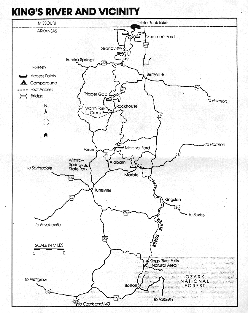
Kings River map
High in the Boston Mountains of Madison County lie the beginnings of the Kings
River. From this steep country the stream
twists its way northward to the White River
and finally flows into southern Missouri's
Table Rock Lake. In its upper reaches, the
Kings cuts a narrow gorge through sandstone, shale, and limestone. On downstream the surrounding countryside is not
quite so precipitous, but the water is the
same, clear and cool.
The Kings' most attractive features are
found along the rocky banks and bluffs
where floaters will notice wild azaleas,
ferns, umbrella magnolias and other fascinating plants. In addition, observant
visitors can view a great many signs of
wildlife - beaver cuttings and deer and
raccoon tracks, for instance - and may
even spot some of the local creatures.
SECTION DESCRIBED
Headwaters to the Arkansas-Missouri border, a distance of approximately 90 miles
CHARACTERISTICS
The headwaters area is, of course, no place
to float, but it does offer some hiking opportunities. One good place in particular is
the Kings River Falls Natural Area, a preserve of the Arkansas Natural Heritage
Commission. In addition to observing the
falls themselves (which drop about 6 feet
over a water-sculpted ledge), visitors can
inspect a great many interesting plants in
the area, and history buffs might try to envsion the grist mill which was once located at
the site. To get there, travel to the community of Boston, located on Arkansas 16. At
Boston, go north on the county road for
about 2 miles until the road forks. Keep to
the right and continue north for another 21/2
miles or so, at which point the road again
forks. Take the left fork, ford the creek, and
then park your car to the right. A trail -
about three-quarters of a mile along and
paralleling the river - will lead downstream to the falls.
While some floating takes place in the
Kingston area, Marble is a traditional starting-off place for many Kings River visitors
(note the put-in is northwest of Marble at a
county road crossing). After eleven miles
of deep pools, overhanging trees, occasional rapids, and several large bluffs,
floaters will arrive at Marshall Ford. an access point northeast of Alabam.
The second Kings River stretch is the
Marshall Ford to Rockhouse run, a 15-mile
trip through quiet and attractive country.
Access to the river at Rockhouse is a little
out-of-the ordinary: floaters must navigate
a feeder stream (Warm Fork Creek) for a
few hundred yards before entering or exiting the Kings.
A seven-mile stretch from Rockhouse to
Trigger Gap is the third in the series, and
offers a peaceful float. The take-out point is
a low-water bridge on Arkansas Highway
221 about 9 miles southwest of Berryville.
The next section - Trigger Gap to the
U.S. Highway 62 crossing_is a favorite
of Kings River veterans. The 12-mile trip
combines good scenery with good fishing.
Osage Creek, the Kings River's largest
tributary and a float stream in its own right
early in the year, enters on the right about a
quarter of a mile above the U.S. 62 bridge.
A 12-mile float from the 62 crossing to
Summers Ford (off Arkansas 143) is another memorable run, and a popular choice for
fishermen. Some time gravel bars are found
in this stretch of the river
The last Kings River trip begins at Summers Ford and concludes eight miles later
in Missouri at the Highway 86 bridge. Halfway into the trip floaters will encounter
backwaters of Table Rock Lake.
SEASONS
Upstream from U.S. 62, the April-June period is considered best for a float, although
fall rains, if sufficient, can make for good
canoeing. Below 62, floating extends into
early summer.
ACCESS POINTS
General Highway Maps for Carroll and
Madison counties will help floaters locate
the entry points listed in earlier paragraphs.
(note: Visitors are advised that access is not
recommended at the U.S. Highway 68
bridge east of Marble).
SCENERY
Overhanging hardwood forests, fine gravel
bars, and rugged bluffs give the Kings
River good marks in the scenery department. Also attesting to the stream's beauty
is the fact that in 1971 the General Assembly passed legislation to protect that portion
of the river in Madison County, noting that
it "possesses unique scenic, recreational,
and other characteristics in a natural, unpolluted and wild state.'' Thus the Kings
River was actually the state's first stream to
receive governmental recognition and protection, predating the Buffalo National
River legislation by a year.
A float on Kings River is a return to fishing
in its purest form - no motors, no loaded
bass boat, only your partner quietly paddling as you both absorb the untainted outdoor grandeur. The Kings has countless
rock bass and hefty channel cats, but when
fishing this stream, first and foremost on
the minds of most anglers are the big smallmouth bass.
If you want to catch the real Kings River
lunker smallies, take along heavy tackle.
Some people expect bass from this smallish
steam to be small, too, and that can cost
trophy fish which commonly reach four to
six pounds. A baitcasting reel, a medium-
action rod, and 10 to 12 pound line are appropriate.
Two sportfishes often overlooked by
Kings River anglers are the walleye and
white bass. Both species are common in the
portion of the river near Table Rock Lake
during the spring spawning runs in March,
April and early May. White bass will hit a
variety of shad imitation lures and minnows, while walleyes are usually taken on
live baits such as minnows, crayfish and
worms or artificial lures, particularly deep-
running crank-baits and jigs.
SERVICES AVAILABLE
Berryville and Eureka Springs are both located near the Kings River and can meet the
needs of most visitors. In addition, several
outfitters have operations in the area for
those wishing to experience the stream.
OTHER INFORMATION
Folks who enjoy floating the Kings River
will be equally delighted by its sister
stream, War Eagle Creek. War Eagle,
which flows west of the Kings and parallel
to it, is chiefly a springtime float offering
good scenery and fine fishing. Canoes may
be rented at Withrow Springs State Park
which borders the stream north of
Huntsville.
ARKANSAS RIVERS & CREEKS
Big Piney Creek
Buffalo River
Caddo River
Cadron Creek
Cossatot River
Crooked Creek
Eleven Point River
Illinois Bayou
Kings River
Little Missouri River
Little Red River
Mulberry River
Ouachita River
Saline River
Spring River
Strawberry River
White River


![[CleanWeb Approved Site]](cwlogo.gif)
This page hosted by  Get your own Free Home Page
© 1997, 1998 arkoutdoors