Cadron Creek

Cadron Creek map
Each spring dozens and dozens of canoeists load up their gear and head for
north Arkansas's famed Buffalo River.
Many coming from central and southern parts of the state drive up U.S. 65
north of Conway and never realize that
they pass right over another great canoeing stream - Cadron Creek.
The Cadron begins way up in Cleburne County, nearly within the city
limits of Heber Springs. It flows in a
westerly direction, is joined by its
North Fork near Quitman, then continues on a southwesterly course toward
its eventual destination - the Arkansas
River. Along the way the stream passes
by things most might expect - fields
and occasional farm houses - and, for
many, some startling surprises -
rapids, bluffs, and canyon-like surroundings.
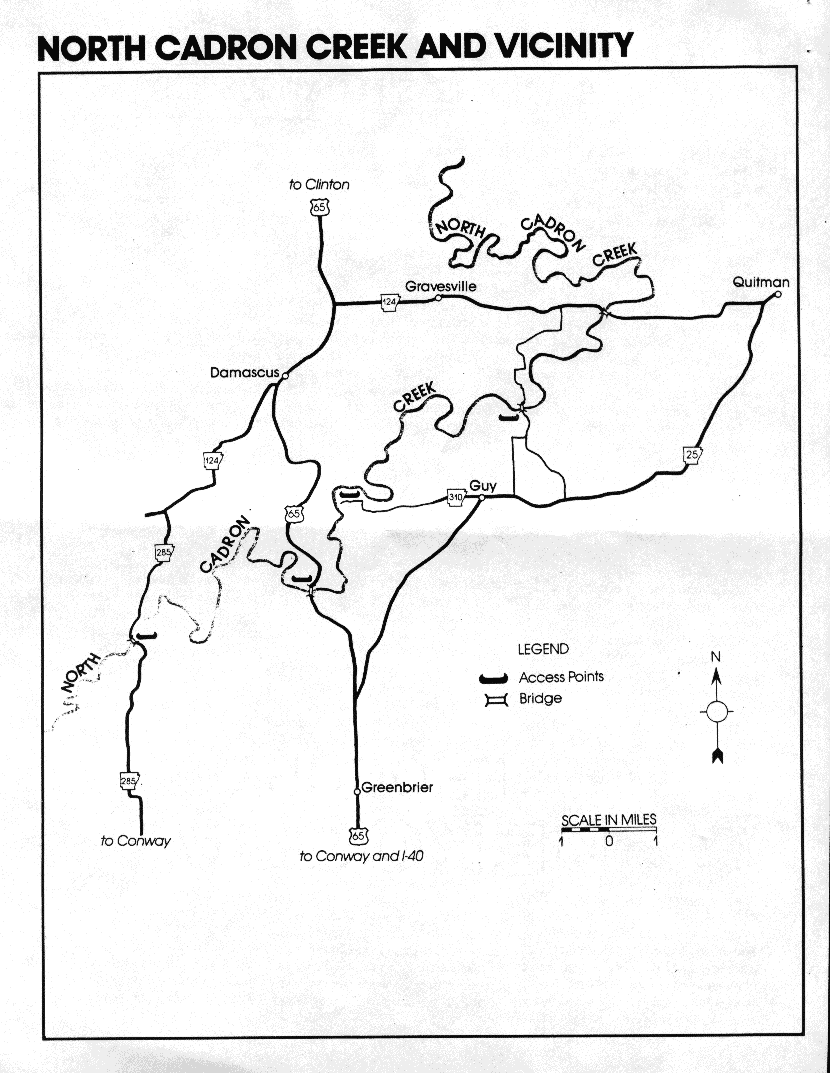
SECTION DESCRIBED
Source to Arkansas River, a distance of
about 59 miles.
CHARACTERISTICS
The Cadron doesn't receive much canoeing use above the Arkansas 124
bridge west of Quitman, although the
North Fork can be floated downstream
from Gravesville.
The first major run
begins at the Highway 124 crossing and
goes down to a county bridge - sometimes called the "Iron Bridge'' -
northeast of Guy. The float is about 4.5
miles long with class I rapids. Incidentally, history buffs might enjoy knowing that the bridge marks the site of the
Hartrick Mill which operated on the
creek from 1868 until the great flood of
1927. Rocks from the old mill dam still
can be seen in the creekbed.
The second section of the Cadron
starts at the county bridge northeast of
Guy (local storeowners can provide directions) and is roughly 10 miles in
length. The take-out point is in an area
known as Pinnacle Springs that was
once the site of a flourishing resort
community in the 1880's. A dozen bath
houses were found in the town, along
with two hotels, a college, a saloon, a
skating rink, and even a cotton gin. To
get to this historic take-out, go west
from Guy for three miles or so on Arkansas 310. The road will end at the
creek. The float is a good one, particularly during its last few miles where the
current picks up. Class II rapids -
some with willow thickets - can be
expected.
The Cadron's third section, Pin-
nacle Springs to U.S. 65, is the shortest of the four, but may be the best of the
lot. In its three and a half mile run, the
paddler will find rocky shoals (up to
class II), quiet pools, and rugged bluffs.
Willow strainers will also be present.
The last float on the Cadron is the 10 - 11 mile trip from the U.S. 65 bridge
down to the Arkansas 285 crossing 10
miles north of Wooster. It, too, offers a
good experience, complete with class I/
class II rapids, the highest bluffs on the
creek, and occasional wildlife.
SEASONS
Cadron Creek is a pretty reliable
stream. One published account claims
it can be floated "90% of the time between December and June. " For a more
accurate day-to-day reading, check the
gauge under the U.S. 65 bridge; levels
of 2.00 feet and above are desirable
(6.00 and up is not recommended).
ACCESS POINTS
Points of access include: the Arkansas
124 crossing; the county bridge northeast of Guy; Arkansas 310 going west
from Guy; the U.S. 65 bridge; and the
Arkansas 285 crossing.
SCENERY
First-time visitors to the Cadron are invariably surprised at the scenery. Most
have no idea that a whitewater stream
exists in central Arkansas, much less
that it features bluffs, pinnacles, and
caves. But all of these attractions are
found on Cadron Creek. Not only that,
the scenery changes from season to season. Many of the bluffs will be ice-encrusted during the winter months; later
on they'll be the locations for waterfalls.
FISHING
By all appearances, Cadron Creek
should be a great little smallmouth
stream. But surprisingly, smallmouth
bass are virtually absent from these
waters. Because the water is warmer
than on most Arkansas float streams,
the Cadron hosts a variety of species
more commonly found in the sluggish
streams of the lowlands.
Here anglers pursue tailwalking
largemouth bass, feisty crappie and the
good-things-come-in-small-packages
bluegill. Flathead catfish, which may
tip the scales at 50 pounds or more, are
also present in good numbers, giving
the visiting angler an outstanding op-
portunity to land a real leviathan.
SERVICES AVAILABLE
Most all supplies can be obtained in
Greenbrier or other nearby communities. Conway, about 15 miles south of
the Cadron on U.S. 65, is a major commercial center with overnight accommodations available. Campgrounds are
located at Woolly Hollow State Park a
few miles northeast of Greenbrier, and
also at the more distant Corps of Engineers' parks on Greers Ferry Lake.
OTHER INFORMATION
Cadron Creek is also "floatable"
downstream from the Arkansas 285
bridge. While it doesn't offer the white-
water recreation of the upstream
reaches, this lower section can be enjoyable.
In addition, the Cadron has a sister
stream - East Cadron Creek - that
can provide several good float trips.
One - the eight-mile section between
Arkansas 36 and 107 - goes past
Mansfield Bluff, Rainbow Falls, Buzzard's Roost, and an interesting array of
tupelo gum trees. A 10-mile float from
the 107 crossing down to a county
bridge is also possible.
Finally, Cadron Creek and its East
Fork flow almost entirely through
private property. Canoeists, therefore,
need to respect the rights of riparian
landowners.
ARKANSAS RIVERS & CREEKS
Big Piney Creek
Buffalo River
Caddo River
Cadron Creek
Cossatot River
Crooked Creek
Eleven Point River
Illinois Bayou
Kings River
Little Missouri River
Little Red River
Mulberry River
Ouachita River
Saline River
Spring River
Strawberry River
White River


![[CleanWeb Approved Site]](cwlogo.gif)
This page hosted by  Get your own Free Home Page
© 1997, 1998 arkoutdoors