
Satellite image of Greenland. You clearly see the ice cap covering almost
entire Greenland. Only in summer the coastal areas are free of snow.
Far left you can see Baffin Island.
(from: NASA)
FACTS
|
Satellite image of Greenland. You clearly see the ice cap covering almost
entire Greenland. Only in summer the coastal areas are free of snow. |
Because the snow-surface reflects most of the sunlight, the temperature is lowest near the snow and increases in upper air levels to 2 km. This is an exceptional situation because usually temperature decreases in higher air levels. The dome structure of the icecap causes cold air to flow constantly to lower areas at the edges. So, crossing the icecap you will always experience head wind until the top of the icecap and then backwind.
Above the seas around Greenland the air is less cold and thus creates a substantial difference in temperature and air-pressure between the coast and the inland. This can cause terrible storms: the feared Piteraqs.
| The Formation of the Greenland ice cap | |
|---|---|
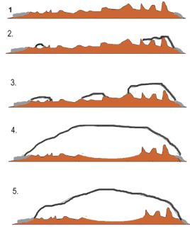 |
1. 50-10 million years ago. We see an ice-free highland, bordered by coast- mountains. The climate is warm |
| 2. Three mil. years ago. The climate gets cooler. The first glaciers appear in the coast-mountains. | |
| 3. Two mil. years ago. The snowfields in the centre highland do not melt anymore in summer. A land glacier comes up. | |
| 4. This land glacier melts together with the glaciers in the coast mountains to make the icecap which also covers the coastal areas. By the increasing weight of the icemasses, the land beneath is pressed down. | |
| 5. After the last ice-age the icecap melts off a little bit, and the coast becomes icefree. | |
At present the maximum thickness of the icecap is 3200 to 3400 meters. It
contains around 2.5 million cubic km of ice. If the icecap should melt, the
sea surface worldwide would rise with 6 to 7 meters! The glaciertongues come
down from the inland-icecap and reach the sea. On the westcoast is the worldfamous
Ilulissat (or; Jakobshavn) icefjord. .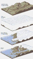 Here
the glacier moves into the sea with an average speed of 20 to 30 meters a day
(= 7 to 11 km. a year) Every day millions of tons of ice calves from the glacier
in the form of icebergs. Seeing these icebergs was one of the most fascinating
experiences I've ever met. Click on diagram on your
right for more details about the formation of this impressive glacier
Here
the glacier moves into the sea with an average speed of 20 to 30 meters a day
(= 7 to 11 km. a year) Every day millions of tons of ice calves from the glacier
in the form of icebergs. Seeing these icebergs was one of the most fascinating
experiences I've ever met. Click on diagram on your
right for more details about the formation of this impressive glacier
Is the icecap growing?
Yes, around 20 to 30 cm. a year. This is a sign for the global warming-up theory and the greenhouse-effect. When temperatures rise, more oceanwater evaporates and causes more precipitation. So in the first phase the amount of precipitation is higher than what the inlandice loses with melting and calving icebergs. But in the end the meltingproces will dominate. (The normal situation is a balance; losses and gains compensate each other). The melting of the ice and rising of the sealevel can have disastrous effects for the earth, especially for the densely populated areas!
Press
here for more, detailed information about the icecore as a climate archive
 |
 |
|
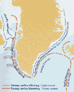
| If you click on the image above, you will find more information about the icebergs tracks | click on the image for details about the seasonal
ice growth around the Greenland seas Click HERE for current ice concentration in the Arctic: |
Hear the sound of cracking and thundering ice in Real Audio
 |
ANATOMY OF AN ICEBERG For detailed information about the destructive forces of icebergs
press button How can icebergs float?Here is the answer
|
 |
| Finally we reached the inlandicecap. From afar we heard the banging of ice, because of the constant movement and temperaturedifferences of the glacier. On this pictures we are about 5 km. from the inland ice. It is a 20 km (rather easy) walk from the airport Søndre Strømfjord (Kangerlussuaq). |
 |
| We celebrated the arrival with whiskey and inlandicecubes, which contains bubbles due to its age (some 10.000 years old). With a little luck you can see the walls breaking into giant pieces with tremendous noise. |

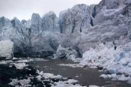
A view over the Ilulissat-icefjord. Completely filled with icebergs, broken off from the icecap. Because of an undepth at the end of the fjord, the icebergs can not go over this threshold and must wait untill it is pressed over it. It is very difficult to estimate sizes, there is nothing to compare with. But the highest tops reaches at least 120 m. (so, 800 meters are below the surface!)


| Iceberg in the midnight sun (click to enlarge 12k) |  |
|
| This is a "fresh calved" iceberg, considering the deep crevasses in the ice; after a while the iceberg will tumble over, because of the fact that the berg gets top heavy by rubbing water and waves. Exactly this unexpected tumbling-over makes icebergs so dangerous to ships |
| Looking downwards into an iceberg (click to enlarge 18k) | 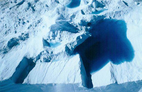 |
|
| After sometime real lakes can be seen inside an iceberg. This image makes clear how crystal clear the water is and why icebergs look so blue. It's said the bluer the ice the "younger" it is. Although that is not always true |
![]()
![]()
)