"Virtual Hike" page 2: Campground near Headwaters
Hill
My buddies and I drove up to O'Haver Lake on Friday, September 25,
1998 - it's about a three hour drive from Denver. We used the
campground as a base - the Marshall Pass summit is another 10 or so
miles up the road. Our plan was to head out early the next morning,
and to hopefully avoid any afternoon thunderstorms.
September 26, 1998
My Dad met us early the next morning. After a quick breakfast, we
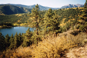
packed our stuff, and drove up towards the pass. The photo above is
from Marshall Pass Road, looking down on O'Haver Lake. I believe
that's Antora Peak in the right background (see
map). We happened to pick what probably turned out to be the
prime weekend for seeing the aspen leaves turning yellow.

October 2, 1999
Just east of the Marshall Pass summit, there's an outhouse and a
rather large parking area. This is where the northbound Continental
Divide/Colorado Trail departs the road. Marshall's actual summit is a
few hundred yards west of there. Some additional parking is there,
and this area serves as the trailhead for the southbound
C.D./Colorado Trails. The photo above shows the sign located there on
the north side of the road; the bald summit barely visible in the
background is Mount Ouray.

October 2, 1999
Looking to the south from the Marshall Pass summit, one can see
Headwaters Hill - about 3 miles in the distance (as the crow flies) -
as well as several other peaks in the area.
(The two photos immediately above were actually taken a year after
my original hike. I went up there again in 1999 with George
Sibley and Ed Quillen - two people who knew about the
significance of Headwaters Hill before I did, and who are now working
with me to get the name officially recognized.)