
| In order for you to understand and accept our national cuisine, we believe it is important that you know the basic geographical features of Croatia and it's agricultural potentials. So let's begin |
| The Republic of Croatia is situated in the south of central Europe. It has the shape of a bow, which spreads from the Drava in the northeast to Boka Kotorska in the south. Croatia occupies the area of 56 538 km2 with the population of 4 760 344 inhabitants ('91). Its capital is Zagreb and it is a part of its continental area. From the beginning Croatia has been a Panonian and Adriatic country, and is made of five large geographical units: |
| 1.) Eastern Croatia (Slavonija and Baranja) -agriculturally it is the most productive part of the country and at the same time its central granary. Due to the sufficient (amount of) precipitation and a moderate climate, Eastern Croatia has good crops of cereals, industrial plants, fruits and vegetables. |
| 2.) Central Croatia - the agricultural and population centre, with the leading city of Zagreb |
| 3.) Northern coast (Primorje) - Istria and Quarnero: region with most highly developed tourist industry. Fishing trade has a very important role |
| 4.) Dalmatia - most densely populated part of coast. Due to the Mediterranean climate, the cultivation of dives, vine, vegetables, figs is very successful. Here, as well, the fishing trade is highly developed. |
| 5.) Mountainous region (Gorski Kotar and Lika) - because of the harsh climate and a lot of snow it is the least developed and the least populated part of Croatia. This part relies on the pasture and rearing of cows and sheep. |
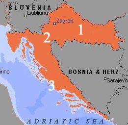 |
| Active map of Croatia - click on a number for display of region |