|
Ubication
Villa
de Cura is located in a valley formerly called valle de Cura. It was
possible the establishment of a populated center because of the
proximity to farm lands which were occupied by the spaniards and their
descendants, especially, toward the Tucutunemo clearing or valley; and
toward the road to Guárico. The presence of Cura, Las Minas, and
Tucutunemo rivers allowerd the human establishment in the area.
Foundation The
city was founded by the General lieutenant Don Juan de Bolívar y Martínez
de Villegas (or Juan de Bolívar y Villegas) in a process, to his
expenses, initiated on March 6, 1.717 when he requested permission to the
governor of Provincia de Venezuela, Don Marcos Betancourt Castro, to found
a village of spaniards in lands of his property in the called Valle de
Cura. The process conclude on May 25, 1.722 when the king Felipe V
approved and ratified the foundation of the new Venezuelan town calle San
Luis in homage to his son, the heir prince of the spanish crown who later
ascended to the spanish throne as Luis V. SurfaceThe surface of Villa de Cura is 448 square km, from a total of 785 square km that conform the Zamora municipality or country.
Altitude Villa de Cura is located at 522 meters over the leved of the sea. Astronomical Position
Altitude
Villa
de Cura is located at 522 meters over the leved of the sea. Climate
Its climate is tropical of savanna and the average temperatura is beiween 24, 4 ºc and 25,2 ºc. Limit
North: with the Ribas and Sucre municipalities from Los Tanques hill goin to the Griteño high, del Tigre cave and from here to the national highway Cagua – Villa de Cura, going to Taiguaiguai lagoon and from here to Las Minas river. West: with the parish San Francisco de Asís and Guárico, following below baters from Las Minas river until the village La Ceniza; then going to potrerito wing line and El Macho until Las Cabras high and from here to Mata Redonda and then to the Las Minas mouth in Taiguaiguai lagoon. East: with San Sebastian municipality from Los Tanques hill to the cataure guich and Zamuro hill, from here to the crag with south direction to the Guárico river. South: leaving Los Cajones going to the Cachicamo hill and Gamelotal pick and then to the south going for Cogollal and Guambra untill arriving to the Guárico river following it below waters until a point in the Guárico to the south of El Peñon high. 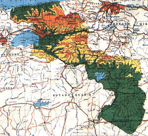 |
[Home]
[Geographical
Location] [Historical
and Tourist Places] [Villa
de Cura Handmade Traditions] [Contacts]


