Home | Korea | The Coromandel | Northland | North Island | South Island | The Coast Road | Otago
Queenstown | Milford Sound | Mavora Lakes | Glenorchy | Time out | Going North again | Wellington| Return of the King |


Central Otago

Mossy arch

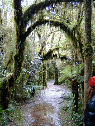
High moisture levels and clean air allow ferns, mosses and lichens to thrive.

Haast Pass Highway

Until the opening of this mountain road in 1965, venturing farther south than Fox Glacier was, for the average tourist, united with considerable difficulty and danger. It is easy to understand why even today, as the narrow road climbs steeply, clinging to the heavily forested mountain sides and allowing you a to look down into a deep, shady gorge and glimpse your own death far too frequently for comfort.

The road actually follows an old Maori greenstone trail known as Tiori-patea, which means "The road ahead is clear". Later settlers did not feel so optimistic about the place, as names like Solitary Creek No 2, Valley of Darkness and Mount Awful testify.

Just after the Haast River Bridge you enter Mount Aspiring National Park, the heart of the Southern Alps. Clouds drift along the mountainsides, snagging on the trees, and waterfalls cascade down on both sides every few hundred metres. (You can see a sample of the vegetation on the right).

The road climbs relentlessly until it reaches the pass itself at 563 metres above sea level. It might not sound like much, but from a road building perspective it is pretty daunting. Then you tip over and start going downhill, alongside the Makarora River.


Roaring Billy

The west coast is one of the wettest regions of the world, and the farther south you go, the worse it gets. But even at Haast, annual rainfall can be over 5 metres - and this can triple at altitudes over 1500 metres. As a result, flash floods, landslides and washouts are common.

It had rained when we went to see Roaring Billy, one of three particularly impressive waterfalls along the Haast Pass Highway, but in comparatively modest amounts. Still, the waterfall could be heard a good way off. We crossed the stony expanse in the foreground - which can turn into a riverbed with scarcely half an hours' notice after heavy rains - and picked a handful of greenstone pebbles on the way.

Roaring Billy

Wanaka

No, I didn't take this one. Someone else took it and then went all Technicolor on it.

Wanaka

The road to Wanaka runs between two lakes, Lake Hawea and Lake Wanaka, and both are edged with snow-capped mountains. (If you want to know what it looks like, take a look at the backdrop to Gandalf's eagle-flight from Isengard).

My guidebook refers to Wanaka as 'almost unfeasibly pleasant', which gives you an idea of why this is one of the most popular regions to buy a holiday home in the entire country. Wanaka could be called a Queenstown in miniature, meaning that it is full of skibunnies and that their cravings for Paul Frank underwear and Quiksilver skijackets can be satisfied locally, and that they can talk over their day on the slopes and giggle over the male powderhound riders over spirulina juice (if it's in the morning) or purple cocktails (if it is the evening).

Nevertheless, Wanaka is quieter and cosier than many ski resorts, and a definitely unfeasibly pleasant time can be had sitting at a waterfront cafe looking out over the lake.


Lazy buggers

Lazy buggers. I'd have their job any day.

Kawarau River

The road from Wanaka to Queenstown takes you through several kinds of very pleasant farming country, pastures and orchards, but the region is probably most famous for its vineyards. The Peregrine and Gibbston Valley wineries are among the most well-known, and they produce the most southerly wines in the world.

As you approach Queenstown, you pass the site where the bungyjump was invented, a bridge over the river Kawarau (sorry). Neither of us were tempted by the 43-metre drop - which seems small compared to some of the ones available nowadays, such as the 134-metre Nevis High Wire - and it seemed that we were not the only ones who chose to pass it by. Consequently, the guys manning the rescue-and-retrieval boats down on the river had themselves an easy time, as you can see in the photo above.

Below, a photo of the road bridge across the Kawarau, taken from the bungy bridge. Just beyond the road bridge is the Pillars of the Kings, the Argonaths - it was not really possible to get a photo from the 'approach' side (we tried, we drove up an absolutely heart-stopping road to a winery on the other side of the river, brandishing cameras, but it was no good) unless you actually were on the river. And if you're on the river, you have other things to think about - adrenaline tends to send your fannishness-levels plummeting. (More about that later).

You can see the peculiarly blue colour of the water - if you have noticed it in the footage of the Anduin, you'd be forgiven for thinking it's some kind of grading trick, but it's a glacier melt water kind of trick. You see it all over the South Island.

Bridge over the river Kawarau

Are you ready? Adventureland, Adrenaline City, Thrillsville, is just around the corner.

Hold on to your hats - let's go to Queenstown!