|
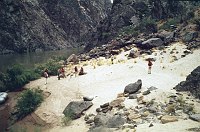
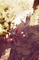
Filename: 091-1L
Description: LEFT - 91.1 MILE. CC=15. MINIMAL USAGE. 1975. NPS, BORDEN.
Object name: L91.1
Credit: 2-10
|
Click here to download
|
|
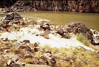
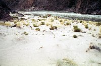
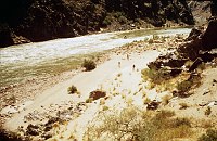
Filename: 091-2R
Description: RIGHT - 91 MILE CREEK. CC=25. MINIMAL USAGE. 1975. NPS,
BORDEN.
Object name: R91.2
Credit: 2-12
|

Click here to download
|
|
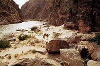
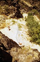
Filename: 091-4L
Description: LEFT - 91.4 MILE. REJECTED. TOO SMALL. 1975. NPS, BORDEN.
Object name: L91.4
Credit: 2-14
|
Click here to download
|
|
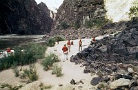
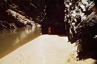
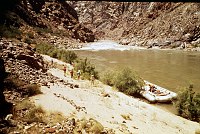
Filename: 091-5R
Description: RIGHT - TRINITY CREEK. CC=20. MINIMAL USAGE. 1975. NPS,
BORDEN.
Object name: R91.5
Credit: 2-16
|
Click here to download
|
|
Filename: 092-2L
Description: LEFT 92.2 MILE. CC=15. MINIMAL USAGE. 1975. NPS, BORDEN.
Object name: L92.2
Credit: 3-18
|
Click here to download
|
|
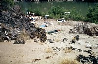
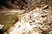
Filename: 093-2L
Description: LEFT - UPPER GRANITE RAPIDS. CC=30. CAMPING WITH TAMARISK.
CONTROLLING VEGETATION. 1975. NPS, BORDEN.
Object name: L93.2
Credit: 2-20
|
Click here to download
|
|
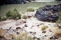
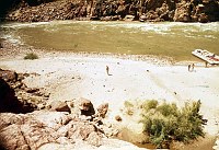
Filename: 093-3L
Description: LEFT - LOWER GRANITE RAPIDS.CC=40. ACCESSIBLE TO HIKERS.
1975. NPS, BORDEN.
Object name: L93.3
Credit: 2-22
|
Click here to download
|
|
Filename: 095-8LL
Description: LEFT - OLD DUNE BEACH (LOWER) CC=8. STABILIZED BY VEGETATION.
1975. NPS, BORDEN.
Object name: L95.8L
Credit: 2-25
|
Click here to download
|
|
Filename: 095-8LU
Description: LEFT - OLD DUNE BEACH (UPPER) CC=8. STABILIZED BY VEGETATION.
1975. NPS, BORDEN.
Object name: L95.8U
Credit: 2-24
|
Click here to download
|
|
Filename: 095-9LL
Description: LEFT - 96 MILE (LOWER) CC=30. 1975. NPS, BORDEN.
Object name: L95.9L
Credit: 2-28
|
Click here to download
|
|
Filename: 095-9LU
Description: LEFT - 96 MILE (UPPER) CC=30. 1975. NPS, BORDEN.
Object name: L95.9U
Credit: 2-27
|
Click here to download
|
|
Filename: 096-5LL
Description: LEFT - BOUCHER RAPIDS (LOWER) CC=10. MARGINAL. 1975. NPS,
BORDEN.
Object name: L95.6L
Credit: 2-31
|

Click here to download
|
|
Filename: 096-5LU
Description: LEFT - BOUCHER RAPIDS (UPPER) CC=10. MARGINAL. 1975. NPS,
BORDEN.
Object name: L96.5U
Credit: 2-30
|
Click here to download
|
|
Filename: 099-1L
Description: LEFT - TUNA RAPIDS. CC=8. 1975. NPS, BORDEN.
Object name: L99.1
Credit: 2-33
|
Click here to download
|
|
Filename: 099-1R
Description: RIGHT - TUNA CREEK. CC=12. MARGINAL. 1975. NPS, BORDEN.
Object name: R99.1
Credit: 2-35
|
Click here to download
|
|
Filename: 099-5L
Description: LEFT - 100 MILE. CC=40. LCR DEPOSITS. 1975. NPS, BORDEN
Object name: L99.5
Credit: 2-37
|
Click here to download
|