Antarctica Ahoy!
Around Scott Base
Expedition Begins
Exploration Area
Exploration Routes
Plateau Loop map
Polar Plateau
Icy Panorama
East Quartzite Range
West Quartzite Range
Upper Glacier
Glacier Route
Middle Glacier
Lower Glacier
Final Stretch
Destination
Conclusion
Diary: Introduction
Diary: Preparation
Diary: Polar Plateau
Diary: Quartzite Xmas
Diary: Into the Glacier
Diary: Home Run
Appendix: Polar Life
Appendix: Logistics
Appendix: Mapping
Thanks
Tararua Antarctic Expedition, 1962-63
Exploration Area
![]()
The Pearl Harbour Glacier – part of the exploration area –
viewed from above the Tucker Glacier confluence.
Two marks at the top of the photo
identify part of the Millen Range,
which is labelled on the map below.
Three marks below the top of the photo
show Mts. Pearson, Tararua and Holdsworth, left to right,
which are marked – but not labelled – on the map below.
![]()
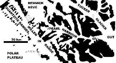
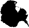
Major features of the area explored,
covering 7800 km² (3000 miles²) in Victoria Land.
White is ice, black is rock, mostly snow-covered.
Start: Point marked “IN”, on the polar plateau, 4 December 1962.
End: Point marked “OUT”, on the Tucker Glacier, 26 January 1963.
![]()